


Evening Video Update: Dixie Fire East Zone Evening Fire Behavior Video Update for August 1, 2021
Evening Video Update: Dixie Fire Incident Update Video for Sunday, August 1, 2021
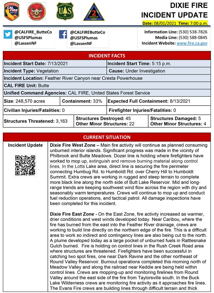
Evening Update Per CAL FIRE: Dixie Fire in Butte County and Plumas County is 248,570 acres and 33% contained for Sunday evening.
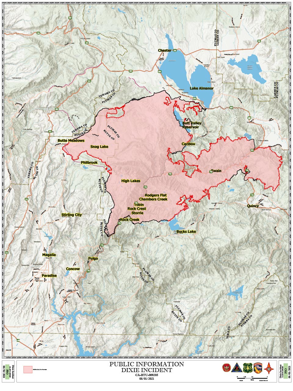
Dixie Fire Public Information Map for Sunday, August 1, 2021
Update 12:45 P.M. Plumas County Sheriff's Office Reports Significant Reductions to the Mandatory Evacuation Orders and Warnings for the Dixie Fire in Plumas County
Update: Dixie Fire West Zone Operations Briefing Video For Sunday, August 1, 2021
Update: Dixie Fire East Zone Operations Morning Briefing Video for Sunday, August 1, 2021
Update: Smoke/Air Quality Outlook for the Dixie Fire in the Eastern Sierra for Sunday, August 1
Update: Dixie Fire in Butte and Plumas Counties Briefing Map for Sunday, August 1, 2021 - Shows Divisions, Uncontrolled Fire Edge, Completed Dozer LinesAugust 1, 2021 - Dixie Fire in Butte County and Plumas County is 244,888 acres and 32% contained for Sunday morning.
Update 7:15 A.M. CAL FIRE
'Click' here to view full PDF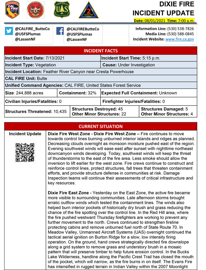
Basic Information
| Current as of | 8/1/2021, 6:35:50 AM |
| Incident Type | Wildfire |
| Cause | Under Investigation |
| Date of Origin | Tuesday July 13th, 2021 approx. 05:15 PM |
| Location | Feather River Canyon near Cresta Powerhouse |
| Incident Commander | CALFIRE Incident Management Team 1/California Interagency Incident Management Team 2 |
| Incident Description | Wildfire |
| Coordinates | 39.819 latitude, -121.419 longitude |
Current Situation
| Total Personnel | 5,563 |
| Size | 244,888 Acres |
| Percent of Perimeter Contained | 32% |
| Estimated Containment Date | Friday August 13th, 2021 approx. 12:00 AM |
| Fuels Involved |
Timber (Litter and Understory) Timber (Grass and Understory) Brush (2 feet) Fuel moistures are historically low, ERCs and BI are in the 97-99% |
| Significant Events |
Minimal Flanking Backing Creeping Fire activity overnight was minimal with backing, creeping and flanking on the unburned islands. |
Outlook
| Planned Actions |
Construct direct and indirect line to secure fire perimeter. Construct contingency lines in both zones. Provide structure defense in communities at risk: Paxton, Greenville, Jonesville, Crescent Mills, Taylorsville, Canyondam, Butte Meadows, Bucks Lake, Meadows Valley, Rush Creek and Greater Alamnor area. East Zone: Firing operations will continue in Division W. Continue tactical patrol in the communities impacted by fire. |
| Projected Incident Activity |
Fire behavior expected to increase due to drying conditions. Fire continues to move towards controls lines burning unburned interior islands and ridges. Steep terrain, heavy fuel loading, and wind in alignment with canyons is making control difficult near div M and N break. On the East Zone expected area to grow is Division X within the Bucks Wilderness area. Firing operations in Division W will gradually increase total acreage over the next three operational shifts. |
| Remarks |
California Interagency Incident management team 2 (CIIMT 2)has command of the East Zone. State DPA: 6551 Federal DPA: 237837 |
Current Weather
| Weather Concerns |
EAST ZONE: Observed: Smoke had continued to clear across even some of the deeper drainage basins across the Dixie East Zone and Evans Fire this afternoon. With the clearing of smoke and clouds temperatures have overachieved and climbed into the upper 80s and 90s. Afternoon humidity values had started to fall into the mid 20 percent range with a few spots seeing humidity in the teens. Afternoon cumulus had bubbled with even some towering cumulus noted south of ICP by the IMET. A few showers and isolated storms had developed along the State HWY 36 and were generally moving toward the northeast. Forecast: Hot conditions with general west winds gusting to around 15 mph. Afternoon humidity may fall down into the teens for a few more sites, but most locations should see RH bottom out near 20 percent. There remains a 20-25% risk for showers and isolated storms across the Dixie East Zone and Evans Fire. Gusty outflow winds along with cloud to ground lightning will be the primary hazards. Activity should diminish after around 2200 LT. Overnight low temperatures are not expected to be quite as low in the valleys and drainages, but it will likely remain mild with temperatures in the upper 50s to near 60 degrees in spots. Overnight humidity values will range as great as 40 percent...even at higher elevations in spots to above 60 percent in the drainage bottoms. WEST ZONE: Decreasing clouds overnight as monsoon moisture pushes east of the region. Evening southwest winds will ease after sunset with nighttime northeast downcanyon winds developing. Return of southwest wind flow on Sunday will keep thunderstorm threat to our east and bring a pretty seasonable weather pattern over the fire. Daytime highs mid 80s higher elevations to mid 90s lower valleys. Less smoke should allow the inversion to lift earlier for the West Zone. Mid and long range trends keep general southwest wind flow across the region with dry and seasonably warm temperatures in place. Observed Weather Conditions: Partly sunny with areas of smoke. Wind Speed/Max. Gust Southwest 8-12 mph gusts 16-22 mph Temp Mid 80s higher elevations with mid and upper 90s lowest drainages. Direction Southwest RH 17-24% Forecasted Weather for Next Operational Period Wind Speed/Max. Gust 14-18 mph Temp Upper 50s lowest drainages to lower 70s ridges Direction Northeast RH 35% ridge and 65% valleys |
