


Click here for: California Dixie Fire Friday, August 13, 2021 Updates
Update: Dixie Fire East Zone Evening Operations Update Video for Thursday, August 12, 2021
Update Per Caltrans District 2: ALERT: State Route 44 is CLOSED in both directions from Jct 36 Lassen County to Old Station (SR89N) Shasta County due to the Dixie Fire.
Update: Dixie Fire West Zone Virtual Community Meeting Evening Update Video for Thursday, August 12, 2021
Evening Update Per CAL FIRE: California Dixie Fire is at 515,756 Acres, with 31% Containment, and 6,160 personnel assigned for Thursday evening.
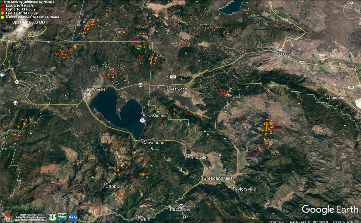
MODIS map of the Dixie Fire in Butte and Plumas Counties on Thursday at 5:00 A.M PST
Note: 1,200 Pixels Wide - Note: Older Yellow not shown
MODIS Active Fire Mapping Program Frequently Asked Questions
Update: Dixie Fire West Zone Operations Morning Briefing Video for Thursday, August 12, 2021
Update: Smoke/Air Quality Outlook for the Dixie Fire in the Eastern Sierra for Thursday, August 12
Update: Dixie Fire Morning Briefing Video for Thursday, August 12, 2021
Update: Dixie Fire East Zone Operations Morning Briefing Video for Thursday, August 12, 2021
August 12, 2021 - Dixie Fire is 510,227 acres and 30% contained for Thursday morning.
Update 7:50 A.M. CAL FIRE
'Click' here to view full PDF
Basic Information
| Current as of | 8/12/2021, 6:20:03 AM |
| Incident Type | Wildfire |
| Cause | Under Investigation |
| Date of Origin | Tuesday July 13th, 2021 approx. 05:15 PM |
| Location | Feather River Canyon near Cresta Powerhouse and Lake Almanor. |
| Incident Commander | CALFIRE Incident Management Team 3 CA Interagency Incident Management Team 4 NPS/BLM |
| Incident Description | Wildfire |
| Coordinates | 39.819 latitude, -121.419 longitude |
Current Situation
| Total Personnel | 6,106 |
| Size | 510,227 Acres |
| Percent of Perimeter Contained | 30% |
| Estimated Containment Date | Monday August 30th, 2021 approx. 12:00 AM |
| Fuels Involved |
Timber (Litter and Understory) Timber (Grass and Understory) Brush (2 feet) Fuel moistures are historically low, ERCs and BI are in the 97-99%. Northern California remains under a Fuels and Fire Behavior Advisory. |
| Significant Events |
Observed Fire Behavior or Significant Events for the Time Period Reported (describe fire behavior using accepted terminology. For non-fire incidents, describe significant events related to the materials or other causal agents): Active Group Torching Uphill Runs Short-range Spotting Narrative: Fire burned actively all day under heavy smoke inversion, with short range spotting and rollout contributing to fire spread. Continued drought conditions and extremely dry fuels allow for ember cast and spotting to increase spread rates. Overall light winds and smoke cover prevented large fire runs, but low afternoon humidity's and high temperatures still allowed the fire to remain active all day. Moderate Risk burn environment. Expect fire behavior to increase with clear skies. Potential to reach triple digit temperatures throughout the week. Haines of 6 will introduce unstable air over the incident. Potential for plume dominated fire behavior due to instability. All fuels remain available. A smoke inversion may settle across the entire fire for both operation periods. Fuel moistures remain critically low for both live and dead. The Energy Release Component is above the 97th percentile and climbing. All thresholds for the Plumas Central have been exceeded. |
Outlook
| Planned Actions |
Construct direct and indirect line to secure fire perimeter. Provide for service calls within communities at risk impacted by fire: Chester, Hwy 36 corridor, Hwy 89 Corridor, Paxton, Greenville, Jonesville, Crescent Mills, Taylorsville, Prattville, Canyondam, Butte Meadows, Bucks Lake, Meadows Valley, Rush Creek, Warner Valley, Pecks Valley, Williams Valley, Hunt Canyon, and Greater Almanor area. Protect threatened areas of Janesville, Indicator Peak and Loan Peak. Heavy mop and patrol of communities impacted by the fire front. Continued mop up of and patrol of 1,000-hr fuels will require a significant amount of resources due to the volume of fuels and the steep and rugged terrain. Firing operations will continue in the West Zone - Division Juliet as weather and staffing allows. Preparation for firing operations around Dyer Mountain. |
| Projected Incident Activity |
12 hours: Moderate overnight conditions. Expect the fire activity to continue to decrease through the morning hours. Overnight recovery will be up to 65%. Potential for crews progress on building containment lines and firing operations. 24 hours: Expect a Moderate risk burn environment due to higher temps, low RH and extremely receptive fuels. The atmosphere will be unstable with a Haines of 6. A smoke inversion may settle across the entire fire for both operation periods. Fire behavior will consist of wind driven surface fire, isolated torching and spotting. Moderate overnight recoveries may provide opportunity for line construction and firing operations. Local thresholds will be exceeded. Expect comparable fire behavior as the previous operational period. The fire will most like spread to the North and Northeast due to sustained SW winds. 48 hours: High risk burn environment due to potential thunderstorms in the region. Temperatures will be in the 100's today and will heat up over the next few operational periods. 30% cloud cover forecasted during the burning period. Fire potential has the potential to transition to very active. 72 hours: Expect similar burning conditions. Temperatures will remain in the high 90's. Models indicate potential moisture in the atmosphere with limited confidence. |
| Remarks |
California Interagency Incident Management Team 4 (CIIMT 4) is in command of the East Zone. CALFIRE IMT 3 is in command of the West Zone. Acreage by DPA: State - 71,919 NPS - 9,320 FS - 408,965 |
Current Weather
| Weather Concerns |
EAST ZONE: Smoke heavily moderated the weather conditions today. Temperatures this afternoon climbed into the mid to upper 90s with a few localized triple digit readings. Minimum relative humidity values dipped into the teens and low teens. Variable drainage winds shifted up canyon in the afternoon with gusts around 9-15 mph. Tonight: mostly clear but anticipate smokey conditions to return with subsequent impacts to visibility. Overnight humidity recoveries will be poor to moderate. Southwest winds will give way to weak drainage wins overnight. WEST ZONE: High pressure continues over the incident and will be the dominate weather feature through the end of the week. This will result in continued warm and dry conditions with winds light and primarily terrain driven, averaging less than 10 mph. Smoke will remain a mitigating factor in the overall weather forecast. Enough moisture and instability will be in place Thursday, and to a lesser extent Friday, for isolated afternoon thunderstorms. Gusty and erratic winds will be possible with any storm. Thick smoke blanketed the majority of the incident today especially where the fire activity was at its highest. The smoke shading kept highs in the 80's but where some sunshine was seen temperatures warmed into the 90s Humidity dropped 10- to 15 across all of the West Zone. Winds were light across the incident with most areas averaging less than 8 mph and totally terrain driven. Smoke is anticipated to fill back in early during the evening hours with winds becoming down slope down canyon. Temperatures are anticipated to drop in the 70s by midnight and humidity recovery is expected to be into the mid to upper 20th percentile. |
Click here for: California Dixie Fire Wednesday, August 11, 2021 Updates
