


Update: Caldor Fire Virtual Briefing & Community Meeting Evening Update Video for Wednesday, August 25, 2021
Update: California Caldor Fire Operational Video Update for Wednesday Morning, August 25, 2021
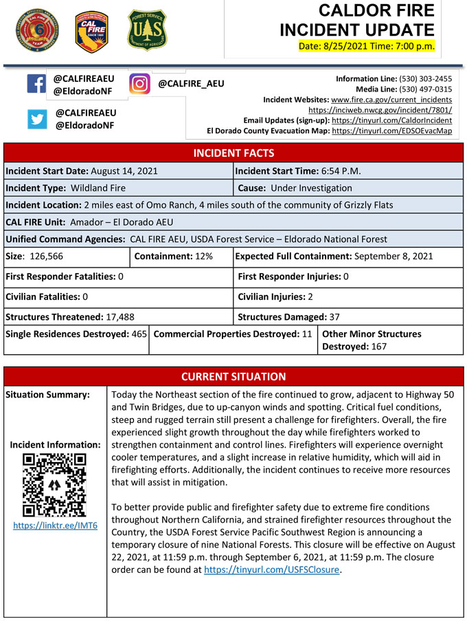
Evening Update Per CAL FIRE: California Caldor Fire is at 126,566 Acres, with 12% Containment, and 2,897 personnel assigned for Wednesday evening.
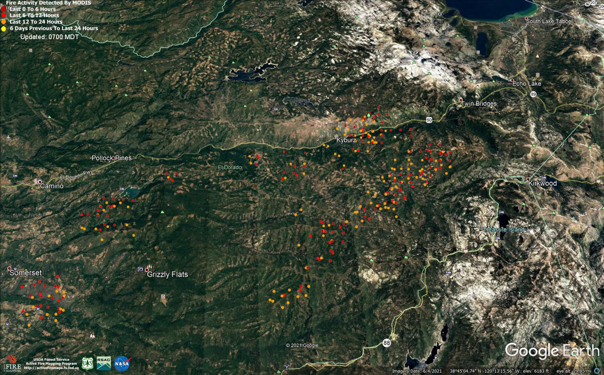
MODIS map of the Caldor Fire on Wednesday at 6:00 A.M PST
Note: 1,200 Pixels Wide - Note: Older Yellow not shown
MODIS Active Fire Mapping Program Frequently Asked Questions
Update: Caldor Fire Virtual Community Meeting Set for 5:00 P.M. Tonight, August 25, 2021
Update: Smoke/Air Quality Outlook for the California Caldor Fire for Wednesday, August 25, 2021
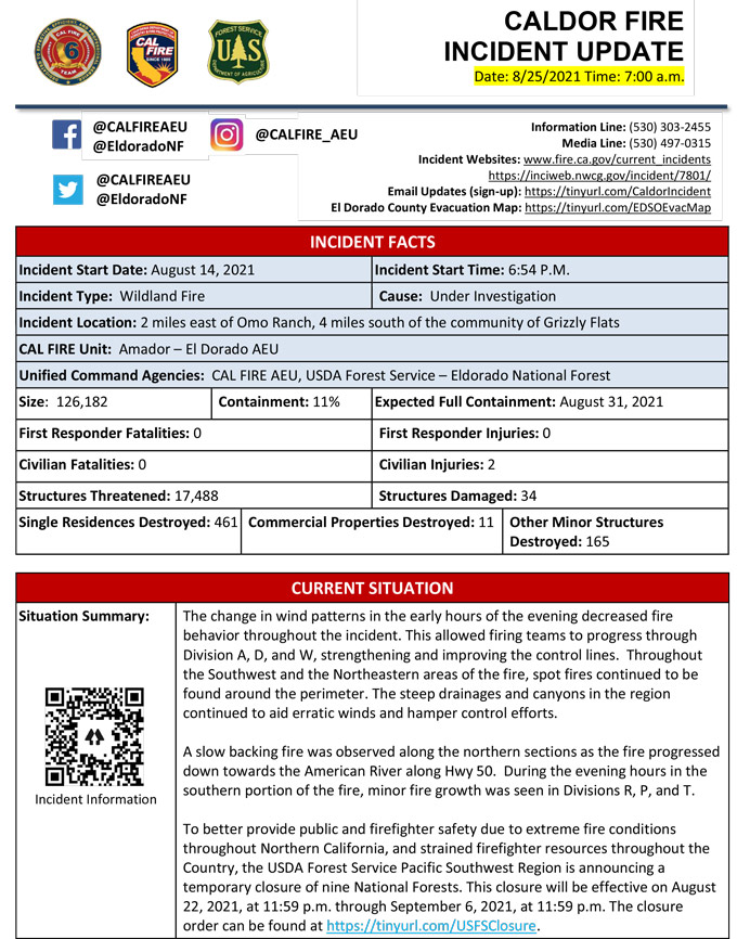
Update: California Caldor Fire Infrared Map for Wednesday, August 25, 2021 - Interpreted Acreage: 126,182
August 25, 2021 - Caldor Fire Update for Wednesday Morning, 126,182 Acres with 11% Containment.
Update CAL FIRE
Basic Information
| Current as of | 8/25/2021, 7:09:23 AM |
| Incident Type | Wildfire |
| Cause | Under Investigation |
| Date of Origin | Saturday August 14th, 2021 approx. 07:00 PM |
| Location | 4 miles South of Grizzly Flats, 2 miles East of Omo Ranch |
| Incident Commander | CAL FIRE AEU, USDA Forest Service – Eldorado National Forest |
| Incident Description | Online Community Meeting 5:00 - 5:30 Pm Https://www.facebook.com/calfireaeu/. Summary: The Fire Was Active In The Early Portion Of The Day Due To The Inversion Layer Lifting Rapidly. The Northeast Side Of The Fire Saw The Most Movement Towards Hwy 50 And Twin Bridges Aided By Up Canyon Winds And Spotting Distances Up To A Half Mile Away. In Areas That Were In Alignment With Winds, Passive Crown Fire Runs Were Seen. Throughout The Incident Spot Fires Continued To Be Found With The Large Spot Fire North Of Hwy 50 Growing Moderately Due To Rollout. With The Moderate Break In Weather, Crews Continued To Improve And Strengthen Containment Lines. To Better Provide Public And Firefighter Safety Due To Extreme Fire Conditions Throughout Northern California, And Strained Firefighter Resources Throughout The Country, The Usda Forest Service Pacific Southwest Region Is Announcing A Temporary Closure Of Nine National Forests. This Closure Will Be Effective On August 22, 2021, At 11:59 P.m. Through September 6, 2021, At 11:59 P.m. The Closure Order Can Be Found At Https://tinyurl.com/usfsclosure. Please Register For Codered Through The Local County Sheriff’s Office El Dorado County Code Red: Https://ready.edso.org/ Amador County Codered: Https://www.amadorsheriff.org/administration-division/codered |
| Coordinates | 38.584 latitude, -120.534 longitude |
Current Situation
| Total Personnel | 2,667 |
| Size | 126,182 Acres |
| Percent of Perimeter Contained | 11% |
| Estimated Containment Date | Tuesday August 31st, 2021 approx. 12:00 AM |
| Fuels Involved |
Heavy timber. Steep terrain. |
| Significant Events |
EL DORADO COUNTY MANDATORY EVACUATIONS ORDERS: - Grizzly Flat: The areas on Grizzly Flats Road east of Kendra Way into Grizzly Flats Proper. The areas of Diamond Railroad Grade, Old School House, Sweeney Road, Caldor Road, and steely Ridge. • Grizzly Flats Road east of four corners in Somerset into Grizzly Flats Proper. - The areas of Myers Lane, Varmet Ridge Road, Rodwell Canyon Road, Snowbird Lane, and Mehwald Lane. • East of Sly Park Road between Highway 50 and Mormon Emigrant Trail to Ice House Road. This includes the communities of Pacific House and Fresh Pond. • North of Highway 50 ,east of Forebay Road to Ice House Road. • Intersection of Perry Creek and Hawk Haven , the East side of Fairplay Road from Perry Creek South to Cedarville Road. This includes Slug Gulch, Omo Ranch, and all roads off of Slug Gulch and Omo Ranch. • All roads off of Omo Ranch from Cedarville Road to Hwy 88. • The area between Highway 88 and Mormon Emigrant Trail • South of Highway 50 from Snows Road to Ice House Road. • Between Highway 50 and Slab Creek from Snows Road to Ice House Road. - South of Highway 50 from Ice House Road to Silver Fork Road. This includes the community of Kyburz. • North of Highway 50 from Ice House Road to Silver Fork Road to include Ice House Reservoir, Union Valley Reservoir, and Loon Lake. EVACUATION WARNINGS: -North of Slab Creek to Wentworth Springs Road between Sand Mountain and Loon Lake. • Mosquito Road from the bridge North to include the Community of Swansboro. • North of Highway 50 to Slab Creek between Smith Flat and Snows Road. • South of Highway 50 to Pleasant Valley between Smith Flat and Snows Road, and North of Pleasant Valley between Holm and Newtown. • South of Pleasant Valley between Bucks Bar Road and Newtown Road, East of Bucks Bar Road to Mt Aukum Road. • Southwest of Bucks Bar Road to Ladies Valley Road including the community of Outingdale, Ant Hill Road, Perry Creek Road and Sand Ridge between Ladies Valley Road and Bucks Bar Road. • East of Mt Aukum Road (E16) from Bucks Bar Road to Omo Ranch Road. North of Omo Ranch Road to the intersection of Omo Ranch Road and Fairplay Road. • South of Omo Ranch to the El Dorado County Line between Mt Aukum Road (E16) and Fairplay Road to include Coyoteville Road, Cedar Creek and all tributary roads. • North of Slab Creek to Wentworth Springs Road between Sand Mountain and Loon Lake. • Mosquito Road from the bridge North to include the Community of Swansboro. • North of Highway 50 to Slab Creek between Smith Flat and Snows Road. • Silver Fork Road in Kyburz east to Twin Bridges. • North and south in a line extending from Twin Bridges to the Placer County line and south to the Amador County line. AMADOR COUNTY - EVACUATION WARNINGS - Shenandoah Road at the Amador County line west through the River Pines community, continuing west on Shenandoah Road to Ostrom Road. South on Ostrom Road to Jibboom Street, West on Jibboom Street to Fiddletown Road. East on Fiddletown Road to Hale Road. South on Hale Road to Shake Ridge Road. East on Shake Ridge Road to Charleston Road. South on Charleston Road to the intersection of Charleston Road and Rams Horn Grade. Due east to Highway 88 at Tiger Creek Road. Tiger Creek Road east to Salt Springs Reservoir Road. East on Salt Springs Reservoir Road to the east end of the Salt Springs Reservoir. Due north from the east end of Salt Springs Reservoir to Highway 88. - South of the El Dorado-Amador County line with a western border of Highway 88 due south to the east end of Salt Springs Reservoir. Southern border of the Calaveras County line. Eastern border of the Alpine County line. SHELTER INFORMATION: - Shelter Green Valley Community Church 3500 Missouri Flat Road Placerville, CA - Shelter- FULL Cameron Park CSD 2502 Country Club Drive Cameron Park, CA - Temporary Evacuation Point Amador County Fairgrounds 18621 Sherwood Street Plymouth, CA - Shelter Evelynn Bishop Hall 701 Hwy 124 Ione, CA 855-755-7711 - Shelter Rolling Hills Church 800 White Rock Road El Dorado Hills, CA ANIMAL EVACUATION INFORMATION: - El Dorado County Animal Services (small animals) 6435 Capitol Ave. Diamond Springs, CA For animal evacuation questions or assistance call (530) 621-5795 - Saureel Vineyards (large animals) 1140 Cold Springs Road Placerville, CA (530) 621-5795 - Amador County Fairgrounds (large animal)- 18621 Sherwood Street Plymouth, CA |
Outlook
| Projected Incident Activity |
Current Weather
| Weather Concerns |
Observed: - Inversion conditions held until after 1100 and smoke was slower to clear the fire area. In the afternoon, temperatures reached the 72-82 degree range with relative humidity minimums lowering into the 27-34 percent range. Southwest to west upslope winds developed at speeds of 4-9 mph with gusts to 15 mph. Over the ridgetops south to southwest winds gusting to around 20 mph were common. Forecast for tonight: - Mostly clear with areas of smoke. Lows 52-62. Humidity recovery 48-58 percent. Winds becoming downslope (easterly) 2-6 mph then becoming southerly and increasing to 10-15 mph after 0500. Outlook for Thursday through Saturday: - High-pressure developing over the region will lower wind speeds and shift the transport winds to the north and northeast. Inversions will be set up earlier and persist longer each day. Temperatures will trend upward and relative humidity lowers each day. |
Click here for: California Caldor Fire Tuesday, August 24, 2021 Updates
