


Update: Monument Fire Operational Video Updates for Tuesday Morning, August 31, 2021
Evening Update: Monument Fire Update for Tuesday evening, the fire has increased to 172,292 Acres with 29% Containment and 2,365 total personnel.

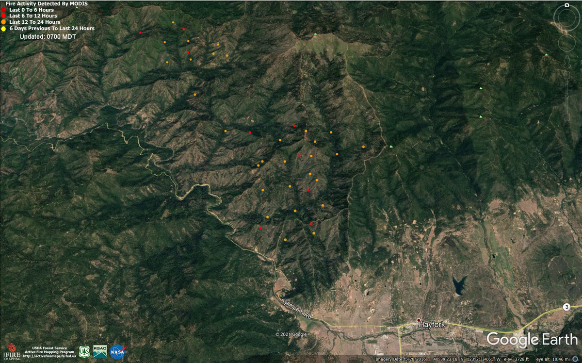
MODIS map of the Monument Fire on Tuesday at 6:00 A.M PST
Note: 1,200 Pixels Wide - Note: Older Yellow not shown
MODIS Active Fire Mapping Program Frequently Asked Questions
Update: Monument Fire Evacuation Information & Updates for Tuesday, August 31, 2021
August 31, 2021 - Monument Fire Update for Tuesday Morning, 170,945 acres with 29% containment.
Update: 11:20 AM. Monument North Zone Fire and Knob Fire Morning Update
August 31, 2021
RESOURCES: 2415 personnel, 36 hand crews, 174 engines, 20 helicopters, 58 dozers, 57 water tenders, 22 masticators
CURRENT SITUATION: The fire is estimated at 170,945 acres and 29% contained. California Interagency Incident Management Team 5 assumed responsibility this morning, August 31, 2021 of the Monument and Knob Fires. The Knob Fire is burning in Humboldt County near Willow Creek in the Six Rivers National Forest.
Monument Fire: Yesterday afternoon and evening, westerly winds in alignment with the Trinity River corridor allowed smoke to clear resulting in increased fire activity in the northern and southwestern portions of the fire area. Frequent spot fires during late afternoon and early evening slowed firing operations north of Hayfork. Around 11:00 P.M. weather conditions improved allowing fire firefighters to continue with tactical firing operations.
Today, fire resources will focus in two areas; the southwest portion of the fire area near Sims Gap and in the north and northeast area in the North Fork Trinity River area. In the southwest portion of the fire, crews will continue to use small check lines along Pattison Ridge to slow the advancing fire. Firefighters will continue to use tactical firing operations along Pattison Ridge to keep the fire in check. Firefighters are also improving a secondary fire line on Hyampom Road.
In the north and northeast portions of the fire, firefighters will continue to watch for any spot fires that occur in the North Fork Trinity River and take actions to mitigate any spread to the east bank of the river. Firefighters will also continue to mop up and patrol the area from Corral Bottom to Burnt Ranch, keeping the fire east of New River.
Knob Fire: The Knob fire which started on Saturday, August 30th, is 764 acres and 0 percent contained. Today, the priority is defense of structures in Willow Creek, preventing the fire from spreading into the Salyer and South Fork River and keeping it east of Friday Ridge.
CA HIGHWAY 299: The highway has reopened with restrictions on the times public travel is allowed through the fire area. Five times a day, starting at 7:00 a.m. and ending at 7:00 p.m., pilot cars will lead vehicle caravans in the section between Burnt Ranch and Helena. These groups will leave from both sides every three hours. Residents may also travel this section of highway between 7:00 p.m. and 7:00 a.m. by showing proof of their address.
WEATHER: Tuesday’s weather will be cooler with increased westerly winds. Low humidity and dry air will increase fire activity, especially in those areas that do not have shading from smoke.
EVACUATION ORDERS:
Monument Fire: Yesterday, Sunday August 30th, many areas within the Monument Fire area had changes to the evacuation orders and warnings. Please refer to the Trinity County Office Sheriff Facebook page for detailed information on closures at Trinity County Sheriff's Office | Facebook
Knob Fire: Areas west of Hwy 299 to the end of China Creek, south of Butterfly Creek Road to Christian School Road, excluding residents of Christian School Road. Areas west of Forest Route 6N33 to the end of Fourmile Creek, south of Christian School Road to Friday Ridge Road.
EVACUATION WARNINGS:
Monument Fire: Yesterday, Sunday August 30th, many areas within the Monument Fire area had changes to the evacuation orders and warnings. Please refer to the Trinity County Office Sheriff Facebook page for detailed information on closures at Trinity County Sheriff's Office | Facebook
Knob Fire: Areas east of Hwy 299 to the Trinity River, south of Panther Creek Road to Butterfly Creek Road. Areas east of Hwy 299 to the Trinity River, south of Butterfly Creek Road to Christian School Road, including residents on Christian School Road. Areas east of Forest Route 6N33 to the trinity River, south of Gypo Lane to Friday Ridge Road.
EVACUATION CENTERS:
Monument Fire: Willow Creek Bible Church, 39 Brannan Mountain Road, Willow Creek, CA and Fireman’s Hall Pavilion, 9 Park Street, Fortuna, CA.
Knob Fire: McKinleyville Seventh Day Adventist, 1200 Central Avenue, McKinleyville, CA.
FOREST CLOSURE: Due to extreme fire conditions and lack of additional fire resources, the USDA Forest Service has temporarily closed all National Forests in California, including the Shasta-Trinity and Six Rivers National Forests. Questions can be directed to https://www.fs.usda.gov/main/r5/about-region/offices or by calling 707-562-9113 or email SM.FS.R5inquiries@usda.gov.
ANIMAL EVACUATIONS: Domestic Animals: Trinity County Animal Shelter, located at 563 Mountain View St., Weaverville, CA (530- 623-1370) Domestic + Large Animals: Hoopa Rodeo Grounds on Pine Creek Rd, Hoopa, CA.
CLEAN AIR CENTERS: Trinity County has established a Clean Air Center at the Trinity County Library, 351 Main Street, Weaverville. Hours are Monday, Wednesday and Friday from 1-6 p.m. and Tuesday and Thursday from 10 A.M. to 6 P.M.
PROPERTY DAMAGE ASSESSMENTS: Damage assessment teams have confirmed 50 structures have been destroyed. For questions or information regarding the status of your property, call Trinity County Office of Emergency Services (OES) at 530-623-8223.
Basic Information
| Current as of | 8/31/2021, 6:12:52 AM |
| Incident Type | Wildfire |
| Cause | Lightning |
| Date of Origin | Friday July 30th, 2021 approx. 06:00 PM |
| Location | Del Loma, CA near Monument Peak |
| Incident Commander | Norm McDonald, Alaska IMT and Mike Parkes, CAL FIRE IMT |
| Incident Description | Wildfire |
| Coordinates | 40.752 latitude, -123.337 longitude |
Current Situation
| Total Personnel | 2,415 |
| Size | 170,945 Acres |
| Percent of Perimeter Contained | 29% |
| Estimated Containment Date | Wednesday December 01st, 2021 approx. 08:00 AM |
| Fuels Involved |
The fire remains squarely within the 2008 Buckhorn, Eagle, Miners and Cedar Fire footprints. Type converted brush and a heavy dead and down component dominate most areas. Fuels to the north of Hayfork are characterized as widely spaced mixed conifer and grass. All live fuels are cured to levels normally seen in late September. |
| Significant Events |
Fire is fuels driven resulting from extended and extreme/enhanced drought with influence of steep slopes and winds. The north portion of the fire from Big Creek to the North Fork Trinity River had very active fire behavior and moderate growth. Additional growth and very active fire behavior occurred in the southeast portion of the fire north of the community of Hayfork. Activity was associated with hot and very dry conditions with steady west winds and good ventilation to allow fire behavior to increase. Flanking and backing fire consumed all surface fuels with moderate flame lengths and rates of spread. Moderate overnight relative humidity recovery has been consistent for the last two nights. |
Outlook
| Planned Actions |
The Shasta-Trinity National Forest has provided the following priorities: 1. Minimize eastern progression of fire towards Junction City and Weaverville, 2. Reduce impacts of southwestern progression to Hayfork and Hyampom while maintaining access to Hyampom, 3. Minimize impact for values at risk to the northwest side of the fire including Burnt Ranch, Hawkins Bar, Trinity Village, Bell Flat, Daily, and Denny. Provide structure defense for the communities of Burnt Ranch, Friedrich Road, Hawkins Bar, Trinity Village, Cedar Flat, Underwood Mountain, 9- Mile Bridge, and Bar 717. In the southwest segment of the fire, patrol and mop-up along Corral Bottom Road/47 Road and Prodigy site. Continue direct handline down Haypress Road. Continue developing and improving primary indirect line along Pattison Road to Pattison Ridge, Pattison Peak Road, down through Halfway Ridge and east to Jud Creek tying in at 9- Mile Bridge to connect with the South Zone. Some heat remains in the confluence of the New and Trinity Rivers. If fire were to become established to the west of the New River, access and resistance to control will be problematic. Spotting has occurred in this area. Patrol and activity within the Highway 299 and Trinity River corridor will be reduced, but resources available to respond if need arises from adjacent divisions. Provide structure defense for the communities from Helena east through Junction City and north along Canyon Creek and the East Fork of the North Fork River. Reinforce indirect line north of the New River from Happy Camp Mountain to the confluence of the Trinity River. Take action on any spots across and west of the New River. Prepare structures along the New River from Five Waters northward towards Denny. Evaluate options for managing fire to keep from progressing east of the East Fork of the North Fork and impacting values of risk to the east. This may include options for direct line to burning out along the East Fork and Hobo Gulch Road. Dozer line along Backbone Ridge within the Trinity Alps Wilderness should be completed on Monday. Continue to prep structures in Canyon Creek and alternate line to be used should fire progress east of the East Fork and Hobo Gulch Road. California Interagency IMT 5 returned and was inbriefed on Sunday. Monday will be a shadow day to develop greater situational awareness. Transfer of Command is scheduled for Tuesday at 0700. Plans are in place for command of the Knob Fire to be taken over by the California Interagency IMT 5. Continue building indirect line in the north portion of Division RR and monitor conditions for opportunities to implement firing operations to the east of Sims Gap. Continue construction of contingency line to protect the community of Hayfork. Continue mop up and patrol along the south portion of the fire in Divisions NN and RR, north of Hayfork. Continue Evaluate equipment needs and allocate resources to Fire Suppression Repair as they become available. |
| Projected Incident Activity |
12 hours: Active fire growth is expected in areas where the smoke clears and currently has established fire and heat. High resistance to control is being realized during direct attack and burn-out holding operations. Dry conditions will contribute to the potential for spotting and active surface fire. Moderate to high fire intensity is expected in the north flank of the fire near French Creek watershed as light up-drainage winds align with steep slopes to increase fire that had been actively burning in surface fuels. 24 hours: Potential for active fire behavior with high resistance to control is likely in uncontained areas as smoke clears. Predicted winds will continue to clear out smoke from the River Complex and increase ventilation throughout the fire. The possibility of clearing and ventilation is increased from previous burn periods as a south-southwest flow will likely push smoke out of drainages on the southern and western flank. Expect moderate to high fire behavior to develop in areas with established fire in areas that clear out by early afternoon. Torching and spotting is expected on the northern flank, mainly the French Creek watershed and west of Backbone Ridge. |
Current Weather
| Weather Concerns |
Observed Weather: Increased westerly flow ahead of an approaching upper level trough brought better ventilation of smoke this afternoon after a stronger morning inversion started to lift. Low temperatures ranged in the 50s to low 60s in thermal belts with humidity recovery of 25-40% on ridges and 60-80% in drainages. Stronger west winds elevated the strength of up-canyon winds, with peak gusts near 25 mph within aligned drainages and across exposed ridges during the late afternoon and into the evening. High temperatures ranged from the mid 90s in valleys to near 80 across ridges with minimum humidity in the 11-20% range. Tuesday Outlook: Trending cooler Tuesday with increased westerly flow as an upper level disturbance moves across the Pacific northwest. Low daytime humidity will be stronger than typical up-canyon winds in the afternoon and evening. |
Click here for: California Monument Fire Monday, August 30, 2021 Updates
