


While damage assessment continues on all the fires, it is estimated that at least 3,500 homes and commercial structures have been destroyed by the fast-moving wildfires. Emergency Declarations have been proclaimed by Governor Brown for Napa, Sonoma, and Yuba Butte, Lake, Mendocino, Nevada, Orange and Solano counties.
Red Flag Warnings have been issued for much of Northern California due to gusty winds and low humidity starting today. While these winds may hamper the efforts of firefighters, they will also increase the risk for new wildfires.
Residents are urged to remain prepared for wildfires and have an evacuation plan in place. Learn more by visiting www.ReadyForWildfire.org.
Fires of Interest:
**CAL FIRE Incidents**
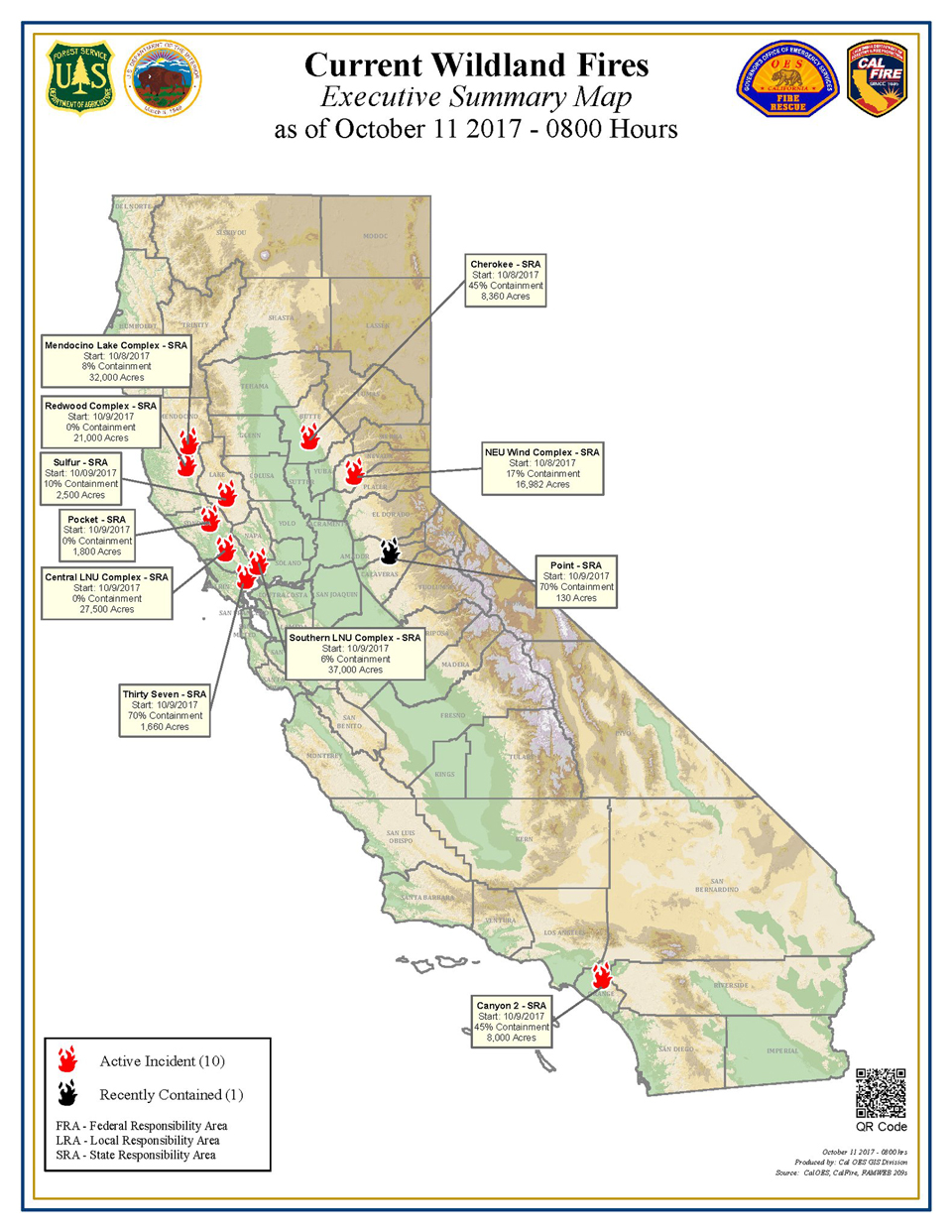
SOUTHERN LNU COMPLEX (6 fires)
- CAL FIRE Incident Management Team assigned
South of Lake Berryessa and northeast of Napa
- 42,349 acres, 3% contained
- Significant structures destroyed
Partrick Fire, Napa County(more info…)
west of Napa
- 9,523 acres, 2% contained
Nuns Fire, Sonoma County(more info…)
Hwy 12 north of Glen Ellen
- 7,626 acres, 2% contained
Norrbom Fire, Sonoma County
east of Boyes Hot Springs
- 1,831 acres,
Pressley Fire, Sonoma County
East of Rohnert Park
- 473 acres
Adobe Fire, Sonoma County
Near Kenwood
- 8,202 acres
MENDOCINO-LAKE COMPLEX (2 fires)
- CAL FIRE Incident Management Team assigned
North of Hwy 20 in Potter Valley and Redwood Valley
- 29,500 acres, 5% contained
- Significant structures destroyed
Sulphur Fire, Lake County (more info…)
Clearlake Oaks
- 2,500 acres, 40% contained
WIND COMPLEX (4 fires)
- CAL FIRE Incident Management Team assigned
Loma Rica area
- 12,349 acres, 20% contained
- Significant structure destroyed
Lobo Fire, Nevada County (more info…)
Rough and Ready area
- 857 acres, 30% contained
- Multiple structures destroyed
McCourtney Fire, Nevada County (more info…)
southwest of Grass Valley
- 76 acres, 65% contained
LaPorte Fire, Butte County (more info…)
Bangor area
- 3,700 acres, 15% contained
OTHER FIRES
Point Fire, Calaveras County (more info…)
Hwy 26 & Higdon Rd., West Point
- 130 acres, 70% contained
Cherokee Fire, Butte County (more info…)
North of Oroville
- 8,360 acres, 45% contained
Honey Fire, Butte County
Southwest of Paradise
- 90 acres, 40% contained
37 Fire, Sonoma County
Hwy 37 & Lakeville Highway near Skaggs Island
- 1,660 acres, 70% contained
Ridge Fire, Lake County
west of Indian Valley Reservoir
- 87 acres, 75% contained
Jones Fire, Shasta County FINAL
- 40 acres, 100% contained
**Unified Command Incidents**
CENTRAL LNU COMPLEX (2 fires)
- In unified command with Santa Rosa Fire Department
- CAL FIRE Incident Management Team assigned
Tubbs Fire, Sonoma and Napa Counties(more info…)
Between Calistoga and Santa Rosa
- 28,000 acres
- Significant number of structures destroyed
Pocket Fire, Sonoma County
Pocket Ranch Rd and Ridge Ranch Rd, Geyserville
- 1,800 acres
OTHER
Canyon 2 Fire, Orange County (more info…)
Hwy 91 & Gypsum Canyon Rd, Anaheim City
- 8,000 acres, 45% contained
- Unified command with CAL FIRE, Orange County, Anaheim and City of Orange
**Federal Incidents**
Ice Fire, El Dorado County(more info…)NEW
13 miles east of Camino
US Forest Service – El Dorado National Forest
- 25 acres, 30% contained
- CAL FIRE is assisting
Pozo Fire, San Luis Obispo County(more info…)FINAL
3 miles west of Pozo
US Forest Service – Los Padres National Forest
- 35 acres, 100% contained
Source: CAL FIRE

