


Thursday Air Operations Map
CLICK HERE FOR A LARGE MAP (3,000 Pixels Wide and 3.0MB)

Click here for the Sierra Sun Times Scanner
Reminder: Scanner Information is NOT Official
Click here for Wednesday's Information on the Ferguson Fire
Update: 12:55 P.M. Sierra National Forest Officials Issue Ferguson Fire Order of Closure of Area Roads, Trails, and Recreation Areas
Update: 8:15 A.M. Ferguson Fire Near Yosemite National Park in Mariposa County Thursday Morning, August 16, 2018 Update: 96,810 Acres with Containment at 87%
Update: 8:05 A.M. Forest Service Wildland Fire Smoke/Air Quality Outlook of the Yosemite Area for Thursday, August 16 - Includes Mariposa, Oakhurst and Yosemite
Update: 7:15 A.M. On Thursday, August 16th Mariposa County Air Pollution Control District Reports Ferguson Fire is Affecting Air Quality in the Area
Update: 6:00 A.M. Thursday Morning, August 16 Infrared Map of the Ferguson Fire in Mariposa County Near Yosemite National Park
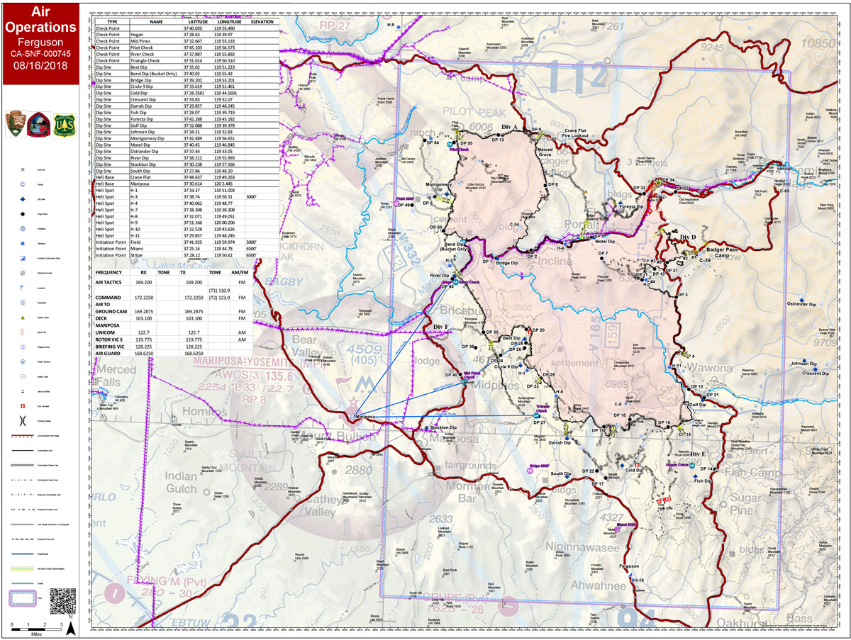
Update: 5:30 A.M. Ferguson Fire Near Yosemite National Park in Mariposa County Thursday, August 16 Operations Map
August 16, 2018 - The Ferguson Fire is burning on the Sierra National Forest near Yosemite National Park in Mariposa County.
Wednesday Evening Information
96,810 Acres with 87% Containment
Planned Actions:
Crews continue suppression efforts on Elephant Rock to Turtleback Back Dome on the northeast flank, of the fire in Divisions D.
The fire east of El Portal and north of Highway 140 is in patrol status.
Crews continue to monitor the fire along FS Road 2S20 and on the 13 Ridge, Resources are addressing hazard trees along roads and containment lines, while monitoring and securing the area.

