


California and National Drought Summary for December 25, 2018
Northeast
December 27, 2018 - Light to moderate precipitation fell on the dry regions in the upper Northeast, but no appreciable change in the abnormal dryness was noted. There are a few additional areas with marginal precipitation deficits on some time scales that will be monitored for potential introduction in future weeks.
Southeast
Moderate precipitation kept most of the region free of dryness and drought, with the exception of southeastern Florida. Three to locally over six inches of precipitation doused the northwestern tier of the D0-D1 areas, eliminating the former D0 areas from approximately Volusia southwestward to parts of Hardee and Polk Counties, but the rain cutoff sharply on its southeastern side, leaving the remaining D0 and most of last week’s D1 intact.
South
Light to moderate precipitation dampened the eastern half of Tennessee, but only light precipitation at best was measured in the western half of the state and portions of the Lower Mississippi Valley, and little or none fell farther west.
The continued dryness in parts of Deep South Texas, the Texas Panhandle, and Oklahoma prompted the expansion of D0 conditions westward through Zapata County in Deep South Texas, and northeastward to cover the central and eastern Texas Panhandle, the Oklahoma Panhandle, and approximately the northwestern half of the remainder of Oklahoma. Most of these areas reported near or less than half of normal precipitation since late October, and deficits of 2 to 4 inches accumulated in north-central and northeastern Oklahoma during this period.
Dryness and drought have been most prolonged in northeastern Oklahoma and adjacent Arkansas, where the depiction was not changed. Many sites reported 6 to locally 12 inches less precipitation than normal since early summer.
Midwest
Dryness and drought is limited to a small area of D0 in northwestern Minnesota, which was unchanged this week, and farther south in an area extending across west-central and southwestern Missouri. D1is confined to a small section of southwestern Missouri covering parts of six counties. Deficits there generally range from 6 to 12 inches in the last six months, and between 2 and 5 inches since late October. Farther north, D0 expanded to cover most of west-central Missouri. The last 60 days have seen 2 to 3 inches less precipitation than normal in the new D0 region.
High Plains
Light precipitation at best (to 0.5 inch in spots) kept dryness and drought unchanged in the northern Plains. Farther south, the dryness farther to the south and east began to encroach on Kansas, but D0 expansion was only expanded into a small section in the southwestern part of the state this week. Moisture deficits have been increasing elsewhere across the southern tier of the state, and the region will be closely monitored for the possible expansion of D0 next week.
Farther west, only spotty light precipitation was observed across Wyoming and Colorado, keeping the large areas of dryness and drought there intact. Much of the D3 and D4 areas in Colorado have accumulated precipitation deficits of 9 to over 15 inches in the last 6 months, and substantial shortfalls date back more than a year in most of those regions.
West
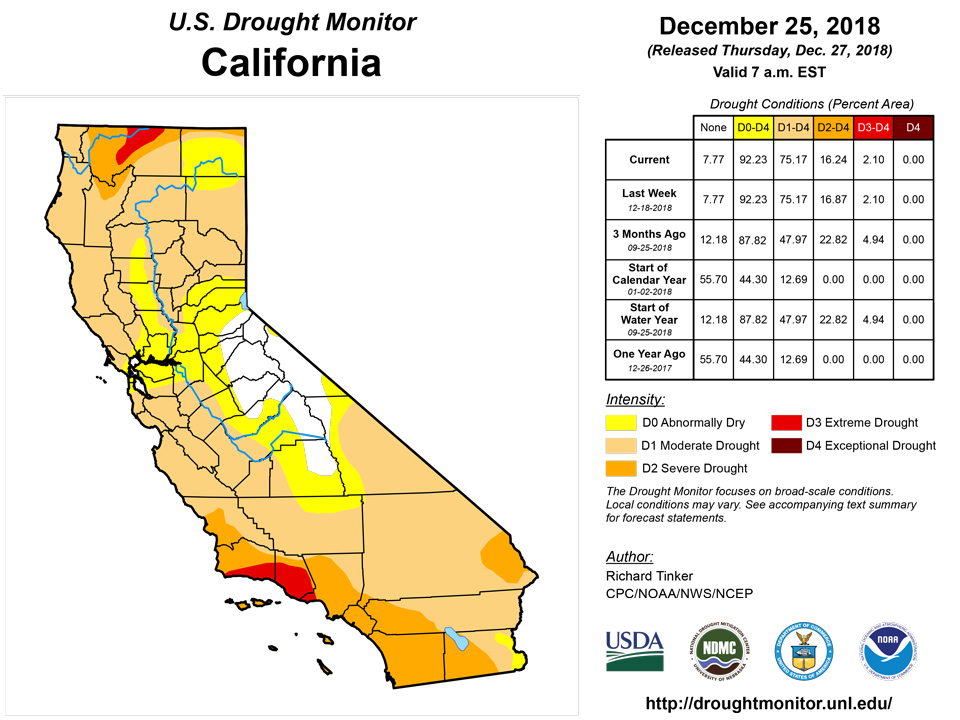
Most areas in the region recorded little precipitation and no change in abnormally dry and drought areas, including the area of protracted drought affecting much of the eastern sections of Arizona and Utah. At least light precipitation fell on most areas north and west of the central Great Basin, with moderate to heavy amounts exceeding 1.5 recorded in much of the Idaho Panhandle, a few spots farther southeast from eastern sections of Washington and Oregon into central Idaho, the higher elevations and northwestern coast of California, and areas of Washington and Oregon from the windward Cascades westward. From northern California to the Canadian border, the heaviest precipitation (3.5 to locally over 8 inches) pelted the immediate coast and the Cascades. But despite the heavy precipitation, reductions in the Drought Monitor depiction were conservative, with D0 eroded from parts of western Washington and northeastern Oregon, plus a few patches of 1-category improvements across the western half Oregon. Despite the heavy precipitation this week, many areas from southwestern Washington thru northwestern California remain 1 to locally 2 or more feet below normal for the calendar year, and only 50 to 75 percent of normal has been measured across large parts of Oregon and some adjacent areas.
Alaska, Hawaii, and Puerto Rico
Drought in the southeastern Alaska Panhandle remained unchanged, as did D0 areas farther north in the Panhandle, along roughly the southwestern half of the Hawaiian Islands, and much of Puerto Rico.
Looking Ahead
During the next 5 days (December 26 – 31, 2018), heavy snow with localized blizzard conditions are expected in the short-term from eastern Colorado and adjacent New Mexico northeastward through the Plains and across the upper Mississippi Valley and northwestern Great Lakes Region. Moderate rain is expected farther south and east. Of the Nation’s dry areas, the snowstorm will likely only impact the D0 in northwestern Minnesota and (to a lesser extent) the eastern Dakotas. Farther south, light to moderate precipitation (0.5 to 1.5 inches for the 5 days) should dampen much of the dry areas across New Mexico, The Oklahoma Panhandle, and portions of the Texas Panhandle and the eastern two-thirds of Oklahoma. Moderate to heavy precipitation (1.5 to 3.0 inches) is forecast across the northern tier of Washington along the immediate western coastline and the windward Cascades, with lesser amounts (0.5 to 1.5 inches) expected farther south into the orographically-favored areas of Oregon. Light precipitation at most is forecast for other existing areas of dryness ad drought, including the upper Northeast and southern Florida
For the CPC 6-10 day extended range outlook (January 1-5, 2019) shows enhanced chances for above-normal precipitation along the northern tier of the Plains and upper Mississippi Valley, much of New Mexico, western and southern Texas, the Southeast, and the Alaskan Panhandle. Subnormal precipitation is favored in most areas from the Rockies westward, and across the central Plains and middle Mississippi Valley.
Author(s):
Richard Tinker, NOAA/NWS/NCEP/CPC
Dryness Categories
D0 Abnormally Dry—used for areas showing dryness but not yet in drought, or for areas recovering from drought.
Drought Intensity Categories
D1 Moderate Drought
D2 Severe Drought
D3 Extreme Drought
D4 Exceptional Drought
Drought or Dryness Types
S Short-Term, typically less than 6 months (e.g. agricultural, grasslands)
L Long-Term, typically greater than 6 months (e.g. hydrologic, ecologic)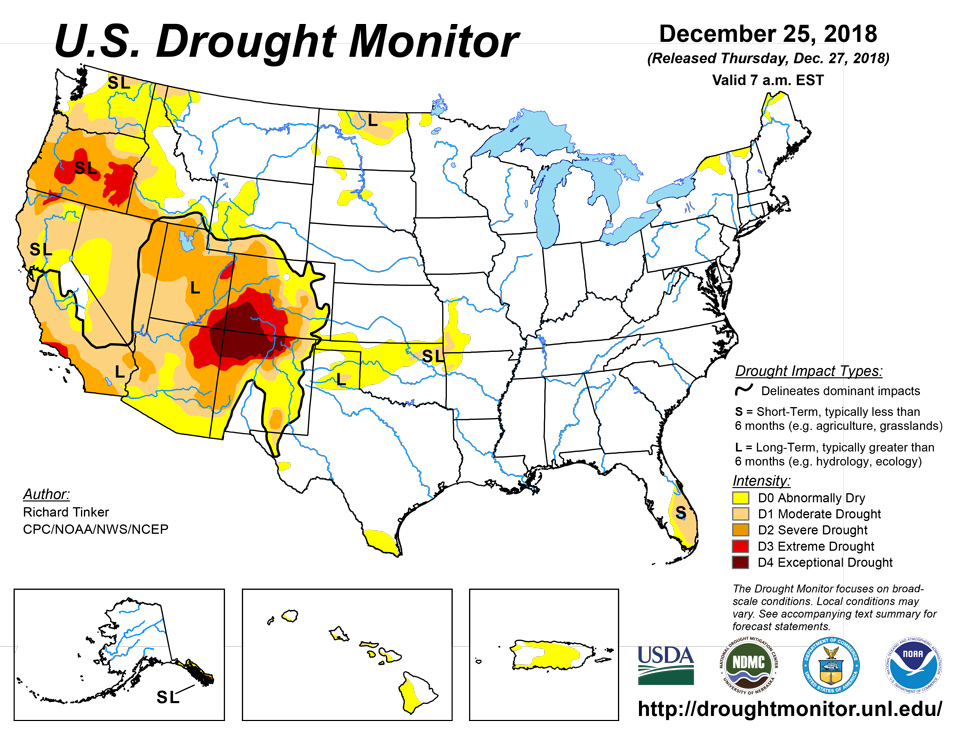
Source: National Drought Mitigation Center

