


California and National Drought Summary for April 9, 2019
Summary
April 11, 2019 - After a dry March, a series of storms brought much needed precipitation to the Pacific Northwest, staving off further degradations in Washington and resulting in local flooding and broad drought improvements in Oregon. Elsewhere, the West remained largely status quo with the only degradation in drought conditions occurring in the Big Horn Mountains where snowpack has been well below normal all winter. The South and Southeast saw a mixture of improvements and degradations. Locally heavy rainfall brought improvements to parts of Texas, Louisiana, and the Carolinas while areas such as southeastern Alabama saw an expansion of moderate drought. Much of the remainder of the country remains largely free of drought and abnormal dryness.
Northeast
The Northeast saw the development of two abnormally dry regions, in western New York and northeast West Virginia. Western New York has experienced precipitation deficits over the last three months, resulting in low streamflow values. While the deficits in West Virginia have occurred over a shorter time scale, they are more pronounced with stations reporting precipitation totals over the last 30 days that fell within the top three driest in a nearly 200-year period of record.
Southeast
The Southeast experienced warmer than normal temperatures. While much of the region saw above normal precipitation, it generally was not enough to overcome deficits of 5 to 7 inches in southern Alabama and the Florida Panhandle that have been in place since the beginning of the year. Small reductions in abnormal dryness and/or moderate drought occurred in southeast North Carolina, northeast South Carolina, and in south Florida. Moderate drought conditions expanded in parts of southeast Alabama, southwest Georgia, and the Florida Panhandle where deficits have continued to grow and streamflow and soil moisture remain low.
South
Locally heavy rainfall, 4 to 8 inches, fell over parts of central and east Texas, southern Arkansas, Louisiana, and northern Mississippi. Abnormally dry conditions and moderate drought were improved in central and southern Louisiana, with dryness/drought persisting in areas where long-term precipitation and soil moisture deficits still exist. Likewise, Mississippi saw a reduction in abnormal dryness in the south-central portion of the state. Texas saw a mixture of improvements and degradations. Conditions generally improved in central and south Texas where severe drought was eliminated and moderate drought and abnormal dryness were reduced in response to the recent rainfall and improved soil moisture. Degradations generally occurred in the north Texas, which missed out on the surplus rainfall and where precipitation and soil moisture deficits continue to build.
Midwest
Cooler than normal temperatures prevailed across the Midwest last week with near normal precipitation falling across much of the region. The region remained free of drought or abnormal dryness.
High Plains
Precipitation across the High Plains was generally near normal over the last week, with the exception of northeast Nebraska and southeast South Dakota. Temperatures were warmer than normal in all but eastern North Dakota. Temperatures ranged from 3 degrees below normal in Grand Forks to 14 degrees above normal in the Nebraska Panhandle. No changes were made to the map this week and the area remains free of drought and abnormal dryness.
West
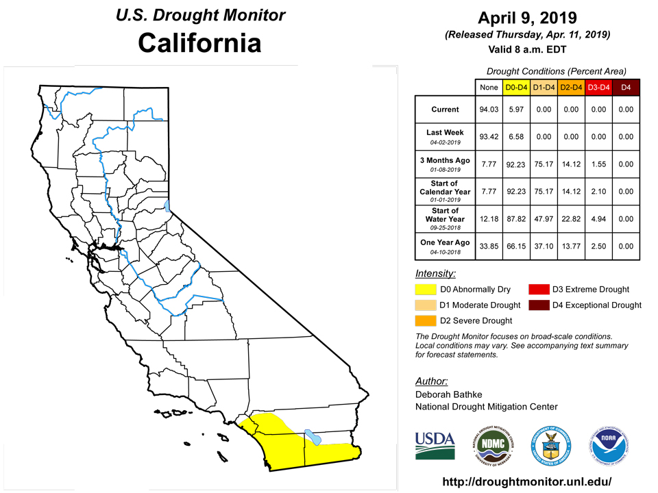
With the exception of Wyoming, conditions in the West improved or maintained status quo. A series of storms brought heavy rain and mountain snow to the Pacific Northwest resulting in the elimination of abnormal dryness in northern California and a one-category improvement over much of Oregon. While Washington also received beneficial rains, the amounts were not sufficient to put a dent in the long-term deficits and drought emergencies still exist in several river basins. Elsewhere, reductions in abnormal dryness also occurred in western Idaho, and in northern and east-central Nevada. Moderate drought conditions developed in the Big Horn Mountains of Wyoming where snowpack has been low all winter.
Alaska, Hawaii, and Puerto Rico
Moderate and severe drought continued in southeastern Alaska. This week, the impact designation was changed from “L” to “SL”, to indicate that the area is experiencing short-term impacts and seasonal shortages in precipitation in addition to those caused by long-term dryness. Reduced hydropower caused by low reservoir levels has necessitated the use of diesel generators, negatively affecting air quality in the region. In Hawaii, weekend rain on the windward side of the Big Island was of little benefit to the existing drought areas. Moderate drought conditions spread eastward into the Honokaa and Ookala areas and over the upper slopes of Mauna Kea. Ranchers in the area reported hauling water for cattle due to poor pasture conditions. Moderate drought also expanded near South Point. The leeward areas of Oahu continued to dry out, resulting in the expansion of moderate drought. Dry conditions have been a contributing factor to recent brush fires outside of Honolulu. Rainfall brought some relief to the abnormally dry areas in northwestern Puerto Rico, with the exception of Rincon, Aguada, and Anasco. Abnormal dryness also developed on the southwestern and south-central part of the island which are experiencing elevated fire conditions.
Pacific Islands
Summary by Richard Heim. El Nino and post-El Nino-like dry conditions continued across parts of the USAPI during this USDM week (4/3/19-4/9/19). Inter-Tropical Convergence Zone (ITCZ) activity occurred across southern Micronesia in the form of a near-equatorial trough in the west, with a couple weak disturbances or circulations moving through it, and converging trade winds in the east. A dry trade wind regime blew drier subsiding air from the North Pacific subtropical ridge (the North Pacific High) across northern portions of Micronesia. The ITCZ convection extended south of the equator as the South Pacific Convergence Zone (SPCZ). The SPCZ was manifested as a surface trough near the Samoan Islands, but its influence was weak due to a competing surface ridge which built over the islands. The ITCZ and SPCZ activity was reflected on satellite-based estimates of 7-day precipitation (QPE) as a broken band of rainfall from southeast Micronesia (across the southern Marshall Islands, RMI) extending west-northwest to the Republic of Palau and Yap State. Areas of 2-plus inches of rain were in this band, with 4-plus inches around northern Palau, parts of Yap State, and from Kosrae State to the southern RMI. Little to no rainfall was indicated on the QPE north of this band. The precipitation band extended south of the RMI to about 10 degrees south, then fell apart toward the Samoan Islands.
Dry conditions continued in the Mariana Islands during the first full week of April. Precipitation between April 3 and April 9 totaled only 0.46 inch on Guam, 0.34 inch on Rota, and 0.12 inch on Saipan. These amounts are all less than 50% of the 1-inch weekly minimums needed to meet basic water requirements on each island. Guam has been below the weekly minimum threshold for six consecutive weeks and fire danger continues to increase, according to the NWS Guam’s forecast discussion. With the lack of precipitation earlier this year and this week, Guam remains in severe drought (D2-S), Rota in moderate drought (D1-S), and Saipan in extreme drought (D3-S). Conditions will continue to be monitored closely for further drought intensification.
This week, Palau received 3.01 inches of precipitation, which is well above the 2-inch weekly minimum required to meet most water needs. However, the island remains in moderate drought (D1-S) due to the insufficient precipitation totals recorded in the previous two weeks (0.08 inch through March 26 and 0.74 inch through April 2) and in February (3.45 inches) and March (6.24 inches).
The 2-inch weekly minimums and 8-inch monthly minimums needed to meet basic water needs were exceeded during the majority of the past few months at Kosrae, Pingelap, and Pohnpei, leaving no concerns of drought and dryness on the islands. Kapingamarangi, Nukuoro, and Chuuk Lagoon have all received precipitation in excess of weekly and monthly minimums the majority of the last few months, but have experienced drier weather the last week (1.06 inches at Kapingamarangi, 0.54 inch at Nukuoro, and 1.61 inches with one day missing at Chuuk Lagoon). These three locations remain free of drought and dryness this week, but will be monitored in the coming weeks. Yap and Fananu have both received adequate precipitation recently with Yap picking up 2.09 inches so far in April and Fananu recording 2.13 inches of precipitation this week (with one day missing). These locations remain in moderate drought (D1-S), however, due to inadequate precipitation the previous two months. Woleai saw abundant precipitation last week (4.55 inches) and was close to the weekly minimum this week (1.63; one day missing), but abnormal dryness (D0-S) remains thanks to the insufficient precipitation in January, February, and March. Lukunor, however, was left free of drought and dryness after receiving 2.57 inches of rain this week, and exceeding the 8-inch monthly minimum in March by picking up 9.57 inches of precipitation.
Extremely dry conditions were found again in the northern two-thirds of the islands this week. Utirik and Wotje saw no rain this week and have both received less than an inch of rain in each of the last two months. Therefore, exceptional drought (D4-S) and extreme drought (D3-S) remain on Utirik and Wotje, respectively. Kwajalein received more rain this week (0.98 inch) compared to last (0.05), but still not enough to meet basic water needs. Kwajalein remains in severe drought (D2-S) with the insufficient precipitation the last three months. Majuro was downgraded to severe drought (D2-S) after not meeting the 2-inch weekly minimum for six of the last eight weeks, and after receiving less than 0.20 inch of rain for two weeks in a row (0.12 inch through April 2 and 0.15 inch through April 9). Additionally, the reservoir on Majuro lost water this week, leaving only 24.186 million gallons as of April 9. This is only 67.2 percent of capacity and is well below the critical 80 percent value. Ailinglapalap was designated as abnormally dry (D0-S) after receiving only 6.90 inches of rain March, and receiving 0.10 inch of rain or less for two weeks in a row (0.10 through April 2 and 0.08 inch through April 9). Despite a dry week last week (0.55 inch), abnormal dryness was removed from Jaluit this week after an ample 3.74 inches of rain fell between April 3 and April 9 following adequate precipitation in March (8.73 inches). Mili saw relatively dry conditions this week (0.81 inch), but has exceeded monthly precipitation minimums the last eight months, leaving no concerns of dryness or drought at this time.
Warm and somewhat dry conditions were observed this week. Pago Pago recorded record high temperatures of 90 degrees for April 8 and April 9 and less than two inches of rain were recorded for the second week in a row (1.66 inches this week with one day missing). However, monthly minimums were exceeded the last nine months so dryness and drought are still not a concern at this point.
Looking Ahead
By the time of this map’s release, a powerful storm will be impacting much of the U.S., bringing heavy rain and mountain snow to the West; blizzard conditions, flooding rain, and severe weather to the Plains and Midwest; and showers and thunderstorms to the South. Behind the storm, parts of the Southern High Plains in Texas and New Mexico will experience fire weather conditions as very dry air and high winds affect the region. As the storm progresses eastward, parts of the Northeast are expected to see rainfall by the end of the week. Another system moving towards the West Coast this weekend is expected to bring low elevation rain and mountain snow to the Pacific Northwest and Intermountain West over the coming week. If the forecast verifies, next week’s map could see additional improvements to drought areas in the Northwest and South.
Author(s):
Deborah Bathke, National Drought Mitigation Center
Claire Shield, National Drought Mitigation Center
Dryness Categories
D0 Abnormally Dry—used for areas showing dryness but not yet in drought, or for areas recovering from drought.
Drought Intensity Categories
D1 Moderate Drought
D2 Severe Drought
D3 Extreme Drought
D4 Exceptional Drought
Drought or Dryness Types
S Short-Term, typically less than 6 months (e.g. agricultural, grasslands)
L Long-Term, typically greater than 6 months (e.g. hydrologic, ecologic)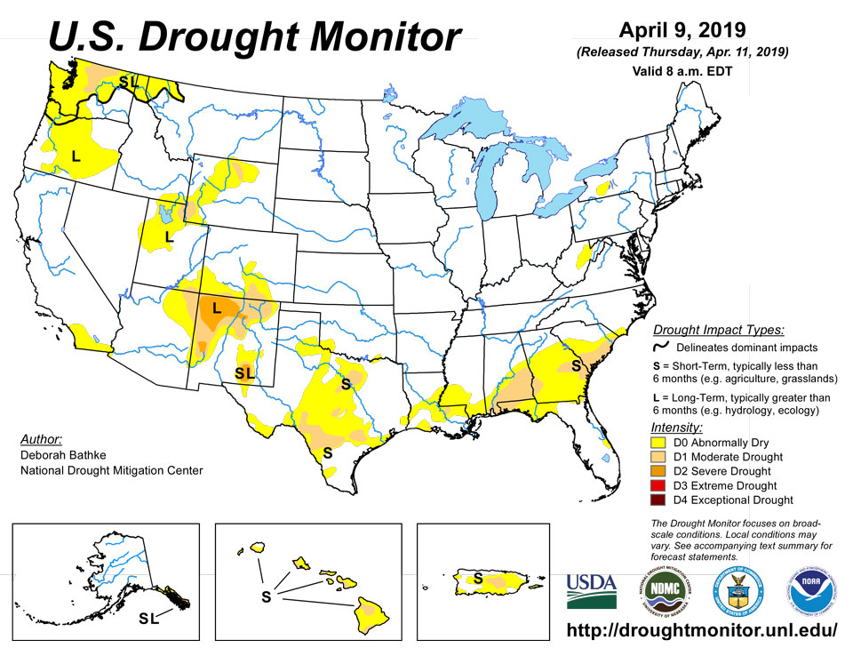
Source: National Drought Mitigation Center

