


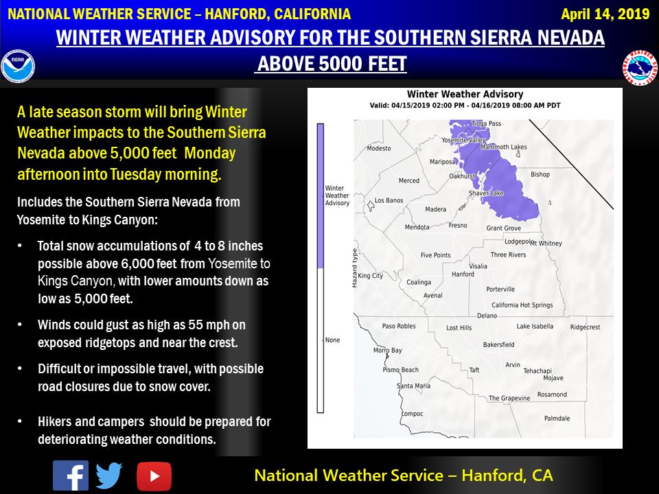
April 15, 2019 - The National Weather Service Hanford Office reports a Winter Weather Advisory is in effect for the Southern Sierra Nevada form Yosemite to Kings Canyon above 5,000 feet from 2:00 PM Monday until 8:00 AM Tuesday.
Snow will begin as early as Monday morning but the heaviest snowfall is expected Monday evening and overnight Monday night.
Motorists should anticipate travel delays with slick, hazardous road conditions, as well as the potential for road closures above 5,000 feet.
If you plan to travel, consider alternate strategies.
If you must travel, remember to carry tire chains, plenty of food, a good deal of water, and warm clothing in your vehicle.
Campers and hikers should be prepared for the onset of more winter like weather conditions.
For information on road conditions, including closures or delays, call Caltrans at 1-800-427-7623 or visit http://www.dot.ca.gov/cgi-bin/roads.cgi.
 Area Forecast Discussion
  National Weather Service San Joaquin Valley - Hanford CA
  326 AM PDT Mon Apr 15 2019

  .SYNOPSIS...
  A storm system will move in this afternoon bringing precipitation
  and increased winds through Tuesday. Temperatures will cool to near
  normal today then a little below normal on Tuesday. Dry conditions
  return Wednesday with a warming trend through the end of the week.


  .DISCUSSION...
  Upper ridge provided an unseasonably warm day for lower elevations
  on Sunday with high temperatures in the lower to mid 80s. Ridge is
  being flattened now as an upper trough approaches the Pacific NW.
  This trough will bring in a cooler air mass more typical for this
  time of year as well as precipitation and increased winds from this
  afternoon through Tuesday.

  Precipitation will begin moving in over northern California later
  this morning and gradually spread south through the day. The latest
  model runs have slowed the system a bit and it now looks like the
  precip will likely hold off until the late afternoon for our area.
  While not a huge system and it does move through fairly quickly,
  it will produce enough snowfall for parts of the Sierra Nevada to
  warrant a Winter Weather Advisory. Snow levels will be around 8000
  at the onset this afternoon, then lower to 6000 feet overnight and
  as low as 5000 feet by Tuesday morning. The Winter Weather Advisory
  is in effect for the Sierra Nevada above 5000 feet from Yosemite NP
  to the northern portion of Kings Canyon NP from 5 PM Monday through
  11 AM Tuesday. This time frame was pushed back 3 hours from earlier
  thinking due to the slower models solutions. The bulk of the snow
  will occur Monday evening, but lingering snow showers and lowering
  snow levels will last into Tuesday morning. Total snow accumulation
  of 4-8 inches is forecast for the Advisory area. Around 1-4 inches
  is possible farther south from Sequoia NP to the Tulare/Kern County
  line. Rainfall amounts will generally be from a quarter to one-half
  of an inch in the mountains. Amounts in the San Joaquin Valley will
  generally be just a few hundredths to a tenth of an inch, though a
  few areas around and east of Merced and Madera could see as much as
  a quarter of an inch. Showers are expected to taper off Tuesday as
  the system shifts to the east.

  Winds will increase this afternoon as the surface pressure gradient
  tightens in response to the incoming trough. A Wind Advisory has
  been issued for a portion of the Kern County Mountains and into the
  Desert from Noon today through 11 PM Tuesday. The strongest winds
  are expected through and just below the mountain passes, especially
  in the vicinity of Mojave where gusts to around 55 mph are possible.
  There will be a decrease in wind speeds for some areas tonight, but
  gusts will increase again on Tuesday before tapering off later that
  night. Breezy conditions will develop across the San Joaquin Valley
  with gusts of 20-30 mph, mainly along the western side.

  High pressure ridge quickly builds in from the Pacific on Wednesday
  and remains in control through the end of the week. This will bring
  dry weather along with a significant warming trend. Temperatures on
  Wednesday will be back near normal and then rise to several degrees
  above normal Thursday and Friday. Highs Friday are forecast to be
  10-15 degrees above normal for mid April with parts of the SJV and
  Kern County Desert possibly reaching 90 degrees. But the models are
  suggesting the heat will be brief as another trough pushes into the
  west coast next weekend for cooling and possibly more wet weather.
Source: NWS

