


California and National Drought Summary for April 16, 2019
Summary
April 18, 2019 - Two rapidly-moving strong storm systems, one “bombing out” in the central Plains during mid-week while a second storm intensified over the middle Mississippi Valley during the weekend, brought severe weather and widespread precipitation to many areas of the lower 48 States, including heavy snows to parts of the north-central Rockies, north-central Plains, and western Great Lakes region. In the Northwest, moderate precipitation falling on an unseasonably late (and above-normal) mountain snow pack (due to a minimal melt from a cold spring) produced near- to record high stream flows in much of Oregon and southern Washington. Widespread precipitation, including mountain snows, fell across Idaho, Montana, northeastern Nevada, Utah, and Wyoming. In the Plains, moderate to heavy rains (1-3 inches) were measured in the south-central sections (Oklahoma and Texas), which then moved into the lower Mississippi and Tennessee Valleys (up to 6 inches in northern Louisiana). To the north in colder air, South Dakota was buried under heavy snow (locally over 2 feet). Moderate to heavy snows also blanketed Minnesota, Wisconsin, northern Michigan, and northern Illinois. Meanwhile, light to moderate precipitation was measured in the eastern third of the Nation, with a stripe of heavier rainfall (1.5-3 inches) falling from northern Georgia northeastward into southern New England. In contrast, most of the Southwest, extreme southern, central, and extreme northern Plains saw little or no precipitation. Temperatures generally averaged below-normal in the western two-thirds of the U.S., especially in the northern Plains and upper Midwest (6 to 12 degF), and above-normal in the eastern third of the Nation (6 to 9 degF in the Carolinas).
Northeast
Most areas received light to moderate precipitation (0.5-2 inches), with a heavier stripe of rain (2-3.5 inches) occurring from southwestern Virginia northeastward into central Maryland, east-central Pennsylvania, eastern New York, and southern Vermont that was associated with scattered reports of severe weather. The widespread rains assured that abnormal dryness and drought would not develop or expand in the Northeast, and it also improved the two small areas of D0 in central West Virginia (erased) and southwest New York (reduced). Although 30- and 60-day SPIs were still showing some D0 and D1 conditions in the central Appalachians and eastern Great Lakes region, long-term wetness and this week’s rains were enough to bring short-term deficits closer to normal, and real-time, 1-, and 7-day average USGS stream flows bounced back to near or above-normal levels in these two areas. Another round of decent rain should eliminate the remaining small D0 in New York.
Southeast
Light to moderate rains (0.5-2 inches) also fell across most of the Southeast, except for portions of southern Georgia and northern Florida (less than 0.5 inches). Locally heavy rains (2-6 inches) fell on western Virginia, western and central North Carolina, northeastern Georgia, and northern Alabama. Short-term dryness/drought (D0-D1) was located across the eastern Gulf and southern Atlantic Coasts, but the widespread rains were enough to prevent deterioration but not quite large enough for widespread improvements. Where heavier totals fell (more than 2 inches), 1-category improvements were made (near Savannah, GA, central Georgia, and southwestern Alabama [D1 to D0]), and D0 to nothing in east-central Alabama, west-central Georgia and southwestern Alabama. In contrast, areas that missed out on the rains (less than 0.5 inches) saw D0 expand slightly into northern Florida as 90-day deficits reached 3-5 inches. Enough rain (0.5-1.5 inches) fell on central and southern Florida to keep D0 from expanding there.
South
With the mid-week (first) storm system mainly impacting areas farther north, the second system that occurred during the weekend developed and rapidly intensified over the southern Plains and lower Mississippi Valley. Widespread moderate to heavy rains (2-4 inches, locally to 6 inches), including numerous reports of severe weather that took several lives, soaked parts of the South, resulting in 1-cat improvements in southwestern and southeastern Oklahoma, northern and central Texas, central Louisiana, and southwestern Mississippi. Arkansas, Tennessee, and northern Mississippi also received abundant rains and remained drought free. In contrast, the rains missed southern sections of Texas and Louisiana, leading to status-quo or some slight D0-D1 expansion. The small D0-D1 area in southwestern Louisiana was shifted southward to better line-up with the driest short-term conditions.
Midwest
Although some areas of the Midwest recorded subnormal precipitation during the past 30-days (Iowa, western Missouri, southern Wisconsin, eastern Kentucky), a record wet 2018 has provided ample subsoil and topsoil moisture for most of the region, and drought impacts are non-existent. Not surprisingly, more precipitation fell across the Midwest, including heavy snows (6-12 inches) that blanketed northern Illinois, southeastern Wisconsin, and southwestern Michigan over the weekend. The first storm system whitened most of Minnesota and Wisconsin with 6-18 inches earlier in the period. There is no abnormal dryness or drought here (flooding more of a concern), and farmers would prefer drier and warmer conditions so they can get into the fields to prepare the land.
High Plains
The mid-week storm system tracked out of the Northwest and into Wyoming, finally dropping decent precipitation (including heavy snow) across much of the state before it moved eastward into South Dakota (up to 26 inches), southern Minnesota (nearly a foot), and central Wisconsin (to 10 inches) by Friday. Liquid equivalents of 1-3.5 inches fell across central Wyoming and much of South Dakota, which was welcome for Wyoming as drier conditions had prevailed there before this week. The storm increased the WYTD basin average precipitation and SWE in Wyoming, with some basins now with WYTD surpluses. Accordingly, a 1-cat improvement was made in central Wyoming where the heaviest totals occurred and WYTD surpluses existed. In northwest Montana, 1-3 inches of precipitation in northwestern Teton, western Ponderosa, and southwestern Glacier Counties was enough to remove D0 as WYTD precipitation and SWE edged above 100% on April 16. Decent precipitation also fell on northwestern Montana (Lincoln County), but longer-term deficits lingered, and D0(L) remained. In Colorado, some scattered precipitation (0.25-1 inches) fell on southern D0 and drought areas, but it was not enough for additional improvements. Drier weather prevailed in Kansas and eastern Nebraska, but that was welcome after wet and cold weather earlier this spring.
West
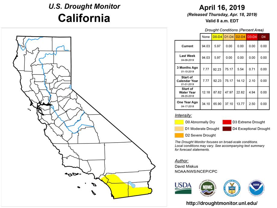
Two storm system brought moisture to most of the Pacific Northwest, northern Rockies, and southward into northeastern Nevada and most of Utah. In the Pacific Northwest (mainly Oregon and Washington), this week's precipitation + late-season snow melt = record high stream flows (flooding), even though WYTD was below-normal in northern areas, and long-term drought (more than 1 year) lingered in some Pacific Northwest areas. Fortunately, reservoirs were filling with the high stream flows, and were expected to rise to normal levels. Accordingly, improvements were made where 12-month SPEIs were normal to wet, precipitation fell this week, and WYTD surpluses existed. Thus, D0 was removed along the southern & eastern edges in Oregon, in central Washington’s Grant & Kittitas Counties, and D1 was shrunk (western edge) in the northern Cascades where 2-5 inches of precipitation fell. In Utah, the same storm system dropped 1-3 inches of precipitation in northern and central Utah, bumping WYTD basin average precipitation to 130-150% and SWE to 150-180% of normal as of April 16. 12-month SPEIs are normal or even wet, thus the western edge of D1 was shrunk and D0 erased thru central Utah. Little or no precipitation fell across the Southwest, but with late winter and spring surplus precipitation, generally below-normal temperatures this year, and mostly WYTD precipitation surpluses, no changes were made in California, Arizona, New Mexico, and Colorado.
Alaska, Hawaii, and Puerto Rico
In Hawaii, the windward slopes of the Big Island had a wet second half of the week from an upper-air low that produced thunderstorms and heavy showers. Windward Maui was also wet, but to a lesser degree. Hilo and other Big Island sites are now above average for April. Thus, D0 was removed from Big Island windward to the higher windward slopes, and windward Maui but only along Haleakala and not the West Maui mountains. Status-quo was determined for the rest of the state.
In Puerto Rico, scattered light showers (0.5-2 inches) fell across southern and eastern sections, preventing dryness and drought from expanding or worsening in these areas. Northern portions were dry, but had surpluses at 60- and 90-days (and no D0 or drought). Thus, no changes were made this week.
In Alaska, light precipitation (1-2 inches) across the southeastern Panhandle was not enough for any improvement, although recent record warmth is melting mountain snow packs, leading to much-above normal (>90th percentiles) USGS average stream flows in southern sections of the state. Status-quo was maintained.
Pacific Islands
Trade wind convergence generated showers across the southern portions of Micronesia during this USDM week (4/10/19-4/16/19), while dry trades blowing out of the North Pacific subtropical ridge (North Pacific High) kept the weather dry across northern and western portions of Micronesia. A near-equatorial trough developed across southern portions of Palau and Yap State near the end of the week, along with a weak circulation in southeastern Yap State. The near-equatorial trough, weak circulation, and trade wind convergence comprised the Inter-Tropical Convergence Zone (ITCZ). Upper-level divergence enhanced the ITCZ convection near the end of the week. A weak cold front/shear line crossed the Marianas, but little rainfall resulted due to the very dry air. American Samoa was caught between a ridge to the north and surface trough to the south. The surface trough was part of the South Pacific Convergence Zone (SPCZ). The ITCZ and SPCZ activity was reflected on satellite-based estimates of 7-day precipitation (QPE) as a broken band of 2-plus inches of precipitation across the southern portions of Micronesia. This band crossed the equator and turned southeast toward, then south of, the Samoan Islands. There were areas of 4-plus inches of rain within the ITCZ and SPCZ bands, mostly away from the primary USAPI weather stations. Little to no rainfall was indicated on the QPE across northern Micronesia, with less than an inch shown over American Samoa. (Summary by Richard Heim)
Dry conditions were found again this week in the Mariana Islands. Saipan received 0.27 inch rainfall while Rota and Guam saw 0.23 inch and 0.06 inch, respectively. These totals are all less than 30 percent of the 1-inch weekly minimum needed to meet most water needs. Drought impacts have also been significant. Guam has seen low stream flows, large brush fires, low surface soil moisture, brown grass, and trees dying. Meanwhile, impacts on Saipan include numerous fires, water salinity issues, cracks in soil, and tree crops suffering. With the recent low rainfall totals and observed impacts, Saipan was downgraded to exceptional drought (D4-S), Rota to severe drought (D2-S), and Guam to extreme drought (D3-S).
Palau saw 0.54 inch of precipitation this week. Rainfall totals have been below the 2-inch weekly minimum for all but two weeks since the beginning of February. February was well below the 8-inch monthly minimum (3.45 inches) and March was slightly less than 2 inches below the monthly minimum (6.24 inches). Precipitation was abundant last week (3.01 inches) and the week of March 13 (4.33 inches) but most other weeks has been less than an inch. Moderate drought (D1-S) remains.
The southern and eastern islands within the Federated States of Micronesia remain drought-free again this week. This week, Chuuk Lagoon (2.70 inches; one day missing), Nukuoro (3.94 inches; one day missing), and Kapingamarangi (2.18 inches; one day missing) exceeded the 2-inch weekly minimums needed to meet water needs. Lukunor (0.85 inch; two days missing), Pohnpei (0.54 inch), Pingelap (0.50 inch; one day missing), and Kosrae (1.30 inches; one day missing) saw somewhat dry conditions this week, but have had adequate precipitation in recent weeks and months leaving no concerns of dryness at this time. In contrast, Yap was downgraded to severe drought (D2-S) since no precipitation fell this week (two days missing), the 2-inch weekly minimum hasn’t been met for nearly three months, and February (1.57 inches) and March (4.88) were well below the 8-inch monthly minimum. Woleai received only 0.11 inch of rain this week (one day missing), but wetter conditions the last two weeks (4.55 inches and 1.73 inches) kept the island only abnormally dry (D0-S). Precipitation was just below the 2-inch weekly minimum this week on Fananu (1.87 inches; two days missing), so moderate drought (D1-S) remains.
Drought in the northern and central Marshall Islands remained and in some cases worsened this week. Wotje has now experienced its fourth consecutive week without precipitation and Utirik has seen its 12th consecutive week with less than 0.10 inch of rain (0.04 inch). Exceptional drought (D4-S) remains on the two atolls. Kwajalein was downgraded to extreme drought (D3-S) after the nearly complete absence of precipitation this week (0.09 inch) and reports of reverse osmosis units being distributed to some areas. Majuro saw more precipitation this week (0.84 inch) compared to last (0.15 inch) but still did not meet the 2-inch weekly minimum. Additionally, the Majuro reservoir remains below the critical 80% capacity level; people are foraging for water, and most home water catchments are depleted. Because water needs are not being met and impacts are becoming significant, Majuro was downgraded to extreme drought (D3-S). Ailinglapalap saw its third week in a row with less than 0.10 inch precipitation (0.09 inch), but remains abnormally dry (D0-S) due to abundant precipitation during a few weeks in March and February. Jaluit received only 1.01 inches of precipitation this week, but remains free of dryness and drought since last week was wet (3.74 inches) and minimum water requirements were met in March (8.73 inches). Mili saw only 1.10 inches of rain this week but remains drought-free thanks to wet conditions the last eight months.
Pago Pago went a third consecutive week with precipitation below the 2-inch weekly minimum (0.85 inch). However, the majority of the last nine months have seen wetter than normal conditions, leaving the area free of dryness.
Looking Ahead
During the next 5 days (April 18-22, 2019), another strong storm system will impact the eastern half of the Nation, bringing heavy rains (2-3 inches) and possible severe weather to the Tennessee, Ohio, and lower and middle Mississippi Valleys and the East Coast. Unsettled weather will also impact the Northwest, Rockies, and most of the Plains, although precipitation totals will be much lower. Temperatures will average above-normal across much of the contiguous U.S., with closer to normal readings likely in the Southeast.
The CPC 6-10 day extended range outlook (April 23-27, 2019) favors above-normal precipitation from the Rockies eastward to the Appalachians and in southern and eastern Alaska, with the strongest probabilities over the southern Plains and the lower Mississippi Valley. Below-normal precipitation odds are likely in California. Above normal temperatures are favored for much of the lower 48 States, while Alaska is expected to see below-normal readings.
Author(s):
David Miskus, NOAA/NWS/NCEP/CPC
Claire Shield, National Drought Mitigation Center
Dryness Categories
D0 Abnormally Dry—used for areas showing dryness but not yet in drought, or for areas recovering from drought.
Drought Intensity Categories
D1 Moderate Drought
D2 Severe Drought
D3 Extreme Drought
D4 Exceptional Drought
Drought or Dryness Types
S Short-Term, typically less than 6 months (e.g. agricultural, grasslands)
L Long-Term, typically greater than 6 months (e.g. hydrologic, ecologic)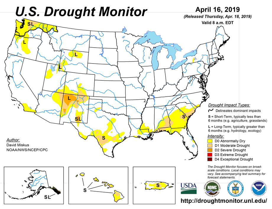 Source: National Drought Mitigation Center

