


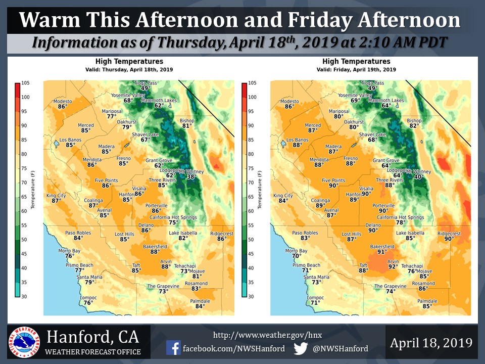
Projected high temperatures for Mariposa for Thursday and Friday: 77 Degrees and 80 Degrees
Projected high temperatures for Oakhurst for Thursday and Friday: 79 Degrees and 80 Degrees
Projected high temperatures for Yosemite Valley for Thursday and Friday: 68 Degrees and 69 Degrees
April 18, 2019 - The National Weather Service Hanford Office reports maximum temperatures this afternoon will be around ten degrees warmer than yesterday afternoon.
High temperatures Friday afternoon will be about fifteen degrees above normal for this time of year.
The daily record for maximum temperature ever measured in Fresno on April 19th is 93 degrees, established in 1950 and most recently observed in 2009.
Temperature records at Fresno date back to 1887.
Area Forecast Discussion
  National Weather Service San Joaquin Valley - Hanford CA
  309 AM PDT Thu Apr 18 2019

  .SYNOPSIS...
  A ridge of high pressure will progress eastward across the
  Western United States today through Friday, resulting in
  high temperatures well above normal for this time of year. Maximum
  temperatures this weekend should return to near normal values for
  late April as a feeble storm system brushes the Southern Sierra
  Nevada. A significant warming trend is expected early next week.


  .DISCUSSION...
  An upper-level ridge of high pressure will move eastward over
  California today, before progressing eastward through the Great
  Basin tonight. An area of low pressure aloft will weaken as it
  approaches Southern California Friday. This atmospheric impulse
  will remain well south of Central California. Maximum temperatures
  this afternoon will be about ten degrees warmer than yesterday
  afternoon. As far as Friday afternoon is concerned, several
  locations throughout the San Joaquin Valley will see temperatures
  reach the 90 degree mark for this first time this year. This is
  about fifteen degrees above normal for this time of year. To put
  this in perspective, the daily record for maximum temperature ever
  measured in Fresno on April 19th is 93 degrees, which was
  established in 1950 and most recently observed in 2009.
  Temperature records at Fresno date back to 1887.

  A rather weak, upper-level trough of low pressure will approach
  the Pacific Northwest Friday night. This trough of low pressure
  aloft should deepen Saturday as it brushes the Southern Sierra
  Nevada. It looks as if precipitation associated with this
  atmospheric disturbance will remain confined to the Southern
  Sierra Nevada. Snow levels should be around 9,000 feet. Minimal
  precipitation is expected in the Southern Sierra Nevada Saturday
  as snow amounts should be less than one inch, with rain amounts of
  less than one tenth of an inch. A Wind Advisory may be required
  for the Kern County mountains and desert Saturday afternoon into
  early Saturday night.

  The aforementioned, upper-level trough of low pressure should
  stall over the Great Basin Sunday into Monday afternoon. A ridge
  of high pressure will build northeastward across Central
  California Monday night through Wednesday, resulting in a
  significant warming trend. By Wednesday afternoon, the vast
  majority of locations in the San Joaquin Valley should see maximum
  temperatures in the lower 90s.
Source: NWS

