


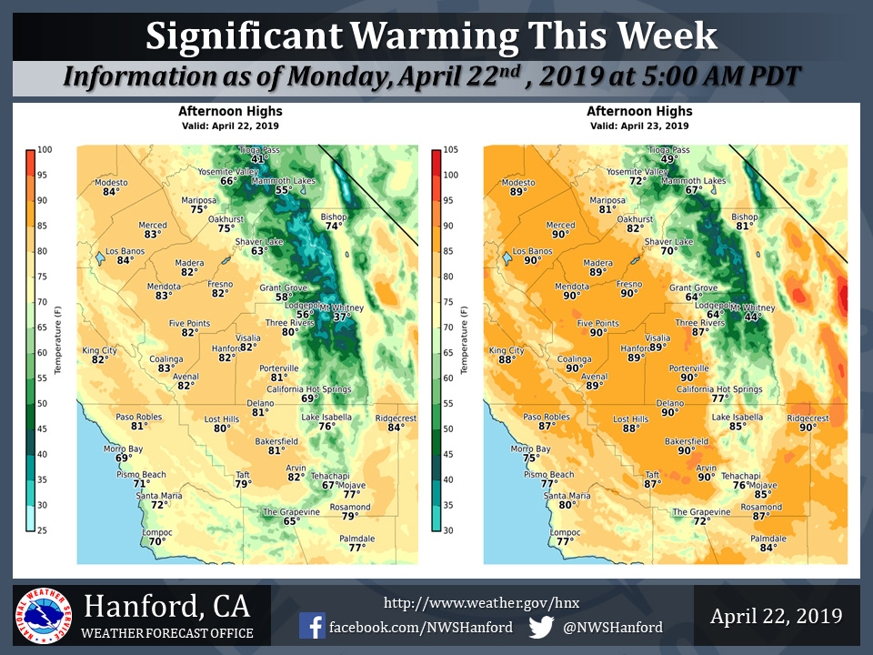
Mariposa Projected High Temps for Monday 75 Degrees and 81 Degrees for Tuesday
Oakhurst Projected High Temps for Monday 75 Degrees and 82 Degrees for Tuesday
Yosemite Valley Projected High Temps for Monday 66 Degrees and 72 Degrees for Tuesday
April 22, 2019 - The National Weather Service Hanford Office reports high temperatures this afternoon will be around five degrees above normal for this time of year.
Maximum temperatures Tuesday afternoon will be ten to fifteen degrees above their typical values for the latter half of April.
Area Forecast Discussion
  National Weather Service San Joaquin Valley - Hanford CA
  439 AM PDT Mon Apr 22 2019

  .SYNOPSIS...Offshore flow and high pressure building over the
  region will bring warmer temperatures and dry conditions across
  central California through the end of the week. A low pressure
  system will bring cooler temperatures and possible precipitation
  for the start of next week.


  .DISCUSSION...
  An upper level low pressure system that brought some precipitation
  and more seasonable temperatures to our area over the weekend is
  currently spinning near the Great Basin area. Skies are generally
  clear over our area in the wake of the departing low, with 24 hr
  temperature trends mostly running up around 3 to 6 degrees.

  The upper low is progged to drop south to northern Mexico by
  Tuesday. Northeasterly flow across the top of the flow will
  produce a moderate offshore flow across our area, with strong
  gusts across the Sierra crest and some gusty downsloping winds
  into the foothills. Model guidance shows the most significant
  wind gusts occurring early this morning and again this evening.

  Meanwhile, high pressure will begin building in behind the exiting
  low, and the ridge will continue to strengthen over the region
  through the middle of the week. This will bring mainly dry
  conditions with a significant warmup. Highs today will be a few
  degrees higher than yesterday, and by Wednesday and Thursday
  temperatures will climb to as much as 15 to 20 degrees above
  climo.

  By the end of the week, models are similar in developing a closed
  low near 30N/130W and swinging it toward the southern California
  coast through the weekend. There are differences in the exact
  track and timing so details are not certain, but we can generally
  look for cooler temperatures and possibly some mountain
  precipitation by the weekend.
Source: NWS

