


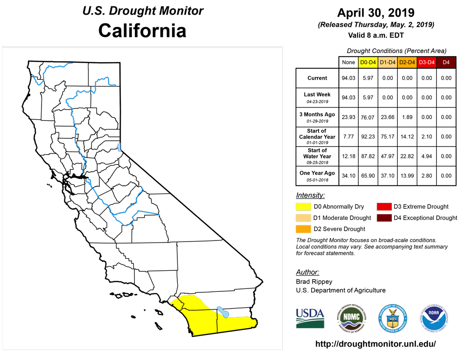
California and National Drought Summary for April 30, 2019
Summary
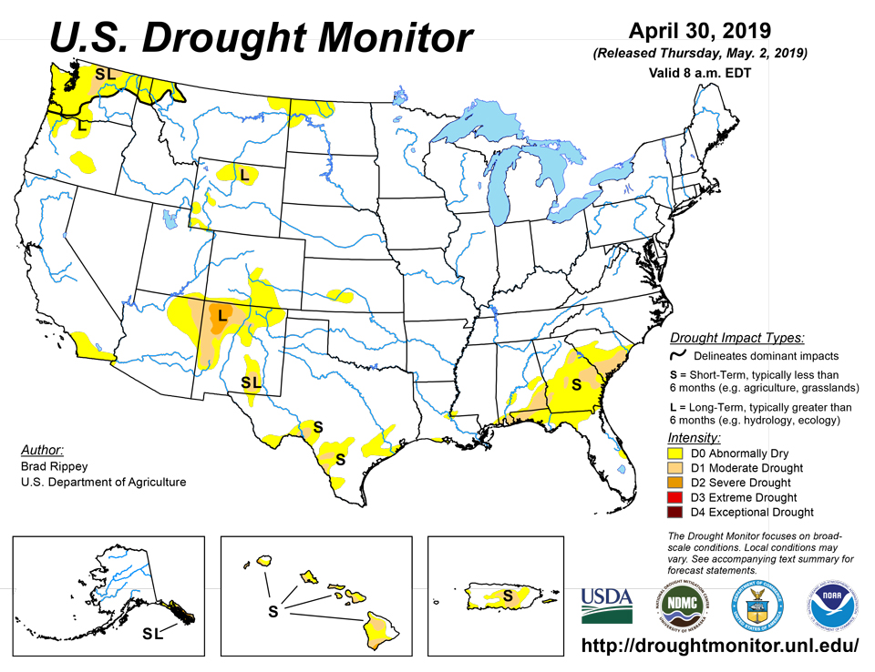
May 2, 2019 - An active weather pattern maintained historically low drought coverage across the contiguous United States, with only a few areas currently experiencing dryness (D0) or moderate to severe drought (D1 to D2). Prior to April 2019, the record-low drought coverage across the Lower 48 States during the 20-year history of the U.S. Drought Monitor stood at 4.52% on May 23, 2017. During the drought-monitoring period ending on the morning of April 30, locally significant precipitation fell in dryness- and drought-affected areas across the Rockies, Intermountain West, northern Plains, and parts of the South. In contrast, little or no precipitation fell in the Far West and the southern Atlantic region.
Northeast
Neither dryness nor drought exists in the Northeast. In fact, significant topsoil moisture surpluses exist in much of the Northeast, according to the U.S. Department of Agriculture (USDA). On April 28, topsoil moisture was rated 100% surplus in Connecticut and 77% surplus in Massachusetts.
Southeast
Short-term dryness (D0) continued to worsen in portions of the southern Atlantic States. In addition, moderate drought (D1) expanded or developed in portions of Georgia and South Carolina. Parts of Florida are being monitored for possible introduction of D0. On April 28, the USDA rated topsoil moisture 32% very short to short in Florida and 22% very short to short in Georgia and South Carolina. Through April, year-to-date precipitation totaled 4.82 inches (43% of normal) in downtown Charleston, South Carolina. January-April totals ranged from 55 to 60% of normal in Georgia locations such as Savannah (7.63 inches) and Alma (8.72 inches). Similarly, the first 4 months of 2019 featured rainfall totaling 60 to 65% of normal in Florida locations such as Sarasota-Bradenton (7.18 inches), Orlando (7.29 inches), and Tallahassee (10.83 inches). In addition, there has been a recent increase in the risk of wildfires in Florida, mainly along and south of the I-4 corridor. The Roger Road Fire, though now fully contained, recently charred 1,127 acres of vegetation in southern Florida.
South
Locally heavy showers swept across the South, especially the central Gulf Coast region and from west-central to northeastern Texas, trimming dryness (D0) and moderate drought (D1). Selected daily-record rainfall totals during the drought-monitoring period included 2.57 inches (on April 25) in Vicksburg, Mississippi; 1.88 inches (on April 24) in Austin, Texas; and 1.37 inches (on April 23) in Oklahoma City, Oklahoma. Dallas-Fort Worth, Texas, recorded 3.57 inches on April 23-24. Lingering pockets of D0 and D1 primarily stretch from southern Texas to the central Gulf Coast.
Midwest
For the tenth consecutive week, the Midwest remained free of dryness and drought. Enough drying took place for corn planting to be 45% complete by April 28 in Missouri, a sharp increase from 16% the previous week. Similarly, corn planting in Iowa was 21% complete on that date, up from 4% on April 21. Still, those values were behind the respective 5-year averages of 55 and 26% in Missouri and Iowa.
High Plains
A new area of abnormal dryness (D0) was introduced in Kansas, where little precipitation has fallen since March 1. Elsewhere, pockets of abnormal dryness (D0) and moderate drought (D1) were limited to Colorado, North Dakota, and Wyoming. Some late-April snow fell in the D0 area of North Dakota, where statewide topsoil moisture rated very short to short stood at 10% on April 28. Coverage of D0 and D1 was reduced in Wyoming and Colorado due to late-April precipitation and generally favorable snowpack values and warm-season runoff prospects.
West
Minimal changes were introduced in the Far West, while slight reductions in the coverage of abnormal dryness (D0) and moderate drought (D1) were made in the Rockies and environs on the strength of late-season precipitation, robust high-elevation snowpack, and increasing confidence in favorable spring and summer runoff.
Alaska, Hawaii, and Puerto Rico
Southeastern Alaska’s region of dryness (D0) and moderate to severe drought (D1 to D2) received mostly light precipitation. However, some heavy precipitation in southernmost Alaska resulted in some slight trimming in the coverage of D2. In Ketchikan, April rainfall totaled 13.73 inches (146% of normal). Farther south, drier-than-normal conditions persisted across much of Hawaii, leading to further expansion of short-term dryness (D0) and moderate to severe drought (D1 to D2). In particular, D2 was expanded northward on Kauai and added in southeastern sections of Maui and the Big Island. Observers in Hawaii’s driest areas have reported degradation in the condition of pastures and other vegetation. Meanwhile, parts of eastern Puerto Rico received heavy rain and experienced local flooding, necessitating a reduction in the coverage of dryness (D0) and moderate drought (D1). In contrast, D1 was expanded in portions of south-central Puerto Rico, where low aquifer levels were among several drought-related problems.
Pacific Islands
The overall weather pattern changed little during this USDM week (4/24/19-4/30/19). Dry trade winds blowing out of the North Pacific subtropical ridge (North Pacific High) inhibited precipitation across northern portions of Micronesia. As these faster trade winds encountered slower winds near the equator, a convergence band was created with precipitation occurring across southern portions of the region. A near-equatorial trough took shape near the end of the week across southern Palau. This near-equatorial trough, convergence, and occasional trade-wind disturbances comprised the Inter-Tropical Convergence Zone (ITCZ). South of the equator, a surface trough persisted just south of the Samoan Islands; it occasionally meandered north to bring rain to American Samoa. Satellite-based estimates of 7-day precipitation (QPE) showed the ITCZ as a long band of 2+ inches of precipitation that stretched the length of the Pacific from east of the Date Line, across Micronesia, to Indonesia. Within this band, a large area of 4+ inches of rain was indicated over the USAPI mostly south of 7 degrees N latitude. Over Palau and Yap State, the band was limited mostly to about 4 to 7 N, but extended to about 2 degrees N over the eastern Federated States of Micronesia (FSM) and the Marshall Islands (RMI), and to near the equator over Chuuk and Pohnpei States. North and south of this band, the QPE showed little to no precipitation. South of the equator, the QPE showed a large band of 2+ inches of rain over the eastern Samoan Islands and south and east of the islands, associated with the southern trough, with embedded areas of 4+ inches.
This week continued dry with less than half an inch of rain received at the regular-reporting stations, and the month was dry (less than the 4 inch monthly minimum needed to meet most water needs). Based on data available as of this writing, weekly rainfall amounts ranged from 0.24 inch at Saipan to 0.43 inch at Tinian. A Red Flag Warning was issued for Guam on April 29 due to the dry weather coupled with windy conditions. Based on data received so far, Guam recorded 1.96 inches of rain for March-April 2019, and this ranks as the third driest such 2-month period in the 63-year record. With 1.41 inches for April, 1.99 inches for March, and 2.84 inches for February, Rota's classification was worsened to D3-S. Guam continued at D3-S and Saipan continued at D4-S.
The Palau Public Utilities Corporation lifted water rationing in Ollei, Ngerchelong due mostly to repairs made on their system. A report was received that the well level at Kayangel (an atoll north of Babeldaob Island in Palau) was 5.5 feet on April 26 and has ranged between 5 and 6 feet for the month of April; the well's capacity is 7 feet. Palau received 2.48 inches of rain this week, which is enough to prevent further degradation. The month was still dry (6.89 inches, which is below the 8-inch monthly minimum needed to meet most water needs), so D2-S continued.
The southern and eastern portions of the FSM were wet (more than the 2-inch weekly minimum) this week, while another week of dry conditions continued to parch the northern and western sections. Based on reports available as of this writing, the wet stations had weekly rainfall totals that ranged from 2.15 inches at Pohnpei to 6.95 inches at Kosrae. On the dry side, reports ranged from zero at Fananu to 0.94 inch at Chuuk. No data was received from Ulithi this week or for the past several months, and most days this week were missing for Woleai, so no analysis could be made for these 2 stations. D3-S continued at Yap, which reported 0.07 inch of rain this week, 1.81 inches so far for April, 4.88 inches for March, and 1.57 inches for February. D2-S continued for Fananu, which had less than the 8-inch monthly minimum for 5 of the last 6 months. D-Nothing continued for Kapingamarangi, Kosrae, Lukonor, Nukuoro, and Pohnpei, which were wet this week, for April, and for the last several months. D-Nothing continued for Pingelap. The last 2 weeks were dry at Chuuk, and April so far has been dry (5.95 inches), but the previous eleven months were wet. D-Nothing continued for Chuuk this week, but D0-S may be considered if the dry weeks continue.
It was another dry week across the Marshall Islands, with less than the 2-inch weekly minimum recorded at all of the regular reporting stations. Weekly rainfall reports ranged from zero in the north at Utirik and Wotje, and 0.03 inch at Kwajalein, to 1.41 inches at Majuro and 1.51 inches at Jaluit. April marked the sixth consecutive dry month at Utirik, so the status was changed from D4-S to D4-SL. Utirik had 0.08 inch of rain for April so far, 0.08 inch for March, and 0.30 inch for February. With 0.16 inch for March-April 2019 and 0.46 inch for February-April 2019, Utirik had the driest March-April and February-April in 12 years of data. D4-S continued at Wotje, where April marked the fifth consecutive dry month. April marks the fifth consecutive dry month at Kwajalein; only 1.14 inches of rain was recorded there this month and 1.22 inches in March, so D3-S continued. This month marks the fourth consecutive dry month at Majuro. Storage in the Majuro reservoirs steadily declined during the first half of April. Due to reservoir water rationing and a few scattered showers, storage held steady during the second half of the month, fluctuating around about 23.6 million gallons. This is about 65.6% of maximum, which is well below the 80% threshold for concern. D3-S continued at Majuro. With only 0.55 inch of rain this week, D1-S continued at Ailinglapalap. This week marks the third consecutive dry week at Jaluit, and only 6.84 inches has been recorded so far this month. Likewise for Mili which had the fourth consecutive dry week with only 2.82 inches of rain for April. Consequently, the status at Jaluit and Mili was changed from D-Nothing to D0-S.
With 6.12 inches of rain this week, Pago Pago's total for April is 10.17 inches, which is above the monthly minimum and continues D-Nothing.
Looking Ahead
During the next couple of days, showers and thunderstorms across the nation’s mid-section will gradually shift into the South, East, and lower Midwest. Five-day rainfall totals could reach 1 to 5 inches or more along an axis stretching from the southeastern Plains into the lower Great Lakes region. In contrast, areas west of the Rockies will experience mostly dry weather and a gradual warming trend. During the weekend, a new surge of cold air will arrive across the northern Plains and upper Midwest, accompanied by rain and snow showers.
The NWS 6- to 10-day outlook for May 7 - 11 calls for the likelihood of wetter-than-normal weather nearly nationwide. Below-normal precipitation should be limited to northern California and the Pacific Northwest. Meanwhile, warmer-than-normal conditions across the Southeast and the Far West should contrast with below-normal temperatures in most other regions, including a large area stretching from the Southwest into large sections of the Rockies, Plains, and upper Midwest.
Author(s):
Brad Rippey, U.S. Department of Agriculture
Richard Heim, NOAA/NCEI
Dryness Categories
D0 Abnormally Dry—used for areas showing dryness but not yet in drought, or for areas recovering from drought.
Drought Intensity Categories
D1 Moderate Drought
D2 Severe Drought
D3 Extreme Drought
D4 Exceptional Drought
Drought or Dryness Types
S Short-Term, typically less than 6 months (e.g. agricultural, grasslands)
L Long-Term, typically greater than 6 months (e.g. hydrologic, ecologic)
Source: National Drought Mitigation Center

