


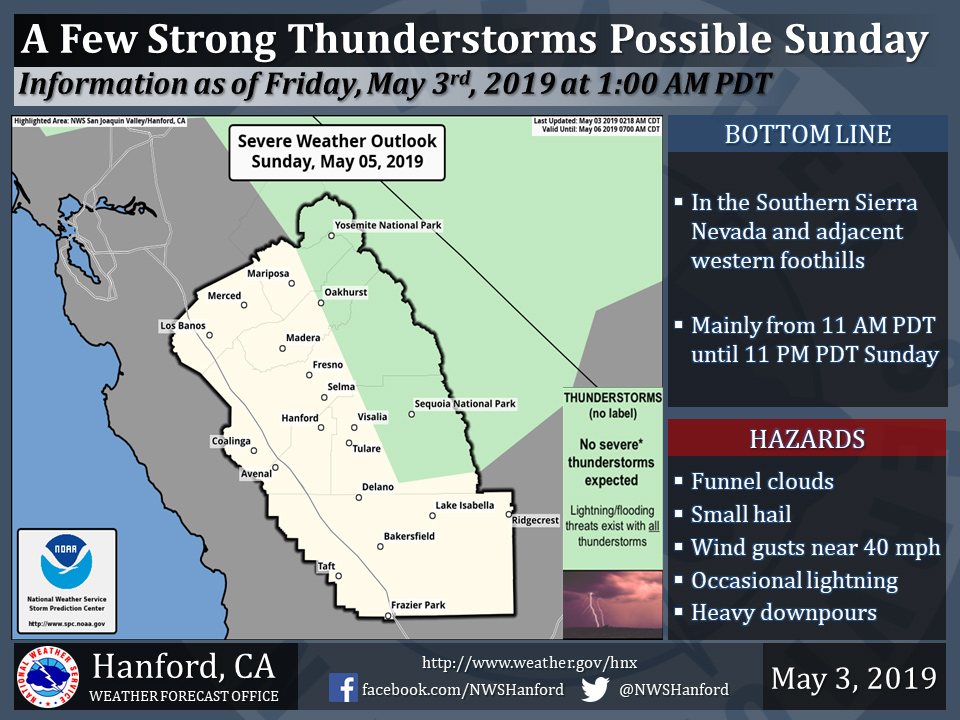
Oakhurst and Yosemite National Park included in possible thunderstorms on Sunday
May 3, 2019 - The National Weather Service Hanfford Office reports a few strong thunderstorms are possible in the Southern Sierra Nevada and adjacent foothills Sunday.
Funnel clouds, small hail, and wind gusts near 40 miles per hour are some of the hazards associated with strong thunderstorms.
In addition to dangerous cloud to ground lightning strikes, any thunderstorm can produce intense rainfall rates, leading to localized flooding.
  Area Forecast Discussion
  National Weather Service San Joaquin Valley - Hanford CA
  215 AM PDT Fri May 3 2019

  .SYNOPSIS...Mainly dry weather will prevail over the area through
  Saturday night with a continuation of above normal temperatures.
  Sunday and Monday will be much cooler and cloudier with increased
  chances of showers and locally breezy to windy.


  .DISCUSSION...The upper-level ridge of high pressure will prevail
  today, and warmer than average temperatures will continue. This
  ridge will move slightly eastward as a closed upper-level low
  approaches the CA coast. Mainly warm and dry conditions will
  continue on Saturday, although as the low moves closer to the
  coast, some instability may be sufficient for some afternoon and
  evening showers/isolated thunderstorms over parts of the Sierra
  Nevada, mainly over the highest elevations. Afterward, the system
  is progged to move onshore and inland over Central California by
  Sunday afternoon.

  Sunday and Monday may be rather cool and unsettled as the low
  pressure system slowly progresses slowly southeastward;
  temperatures could fall to around 10 to 15 degrees below average
  by Monday. However, there is a bit of disagreement between the
  model solutions in terms of the placement of the closed low. In
  addition, this system may stall along the coast, or near Pt.
  Conception, for awhile during Sunday afternoon and evening. Thus,
  expect at least partly to mostly cloudy skies over much of our
  region with more widespread coverage of showers and isolated
  thunderstorms for Sunday. What is more certain, is the upper-
  level low appears to slow down a bit, so shower/thunderstorms
  activity will likely continue Sunday night into Monday. There is
  the possibility for locally gusty winds over the usual prone areas
  in eastern Kern County and along the west side as this low
  progresses inland during late Sunday/Monday. The system will move
  over SE California on Monday evening, so chances of showers will
  decrease.

  Although the upper-level low is centered over Arizona by Tuesday,
  lingering moisture could persist over the mountains. So, have
  kept at least a slight chance of showers for these areas for
  Tuesday and beyond, as another system approaches by Wednesday.
  Additional showers are possible over mainly the higher terrain,
  including much of the southern Sierra Nevada, adjacent foothills,
  as well as the Kern County mountain areas on Wednesday through
  next Friday, as an unsettled trough pattern is forecast to
  continue over the Western U.S. At this time, there is considerable
  disagreement between the latest GFS and Euro solutions, although
  it does not appear another significant warmup is in store for next
  week, as upper-level ridging remains off the West Coast. Therefore,
  temperatures will likely remain at least near seasonal for Wednesday
  through next Friday. Unfortunately, confidence is rather low for
  this particular period, or after 5 days from now.
Source: NWS

