


Projected high temps for Mariposa on Saturday: 78 degrees while Sunday's high temps top out at 70 degrees
Projected high temps for Oakhurst on Saturday: 79 degrees while Sunday's high temps top out at 71 degrees
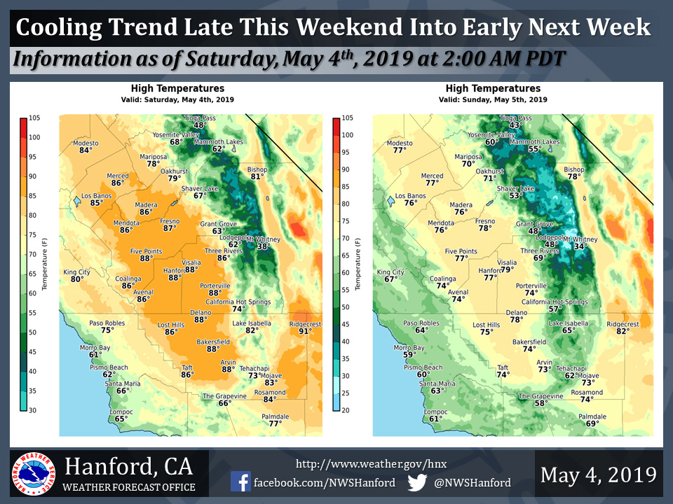
Projected high temps for Mariposa on Saturday: 68 degrees while Sunday's high temps top out at 60 degrees
May 4, 2019 - The National Weather Service Hanford Office reports high temperatures this afternoon will be five to ten degrees above normal for this time of year.
Maximum temperatures Sunday afternoon will be around ten degrees lower than this afternoon.
Even cooler weather is expected Monday, with high temperatures several degrees below normal for this time of year.
Area Forecast Discussion
  National Weather Service San Joaquin Valley - Hanford CA
  250 AM PDT Sat May 4 2019

  .SYNOPSIS...
  Mainly dry and warm weather will persist today, although a few
  showers may develop near the Sierra Nevada crest this afternoon.
  An Eastern Pacific low pressure system will approach the coast of
  California Sunday afternoon. This storm system will be responsible
  for a cooling trend late this weekend into early next week, as
  well as an enhanced chance for precipitation, mostly in the
  Sierra Nevada and adjacent foothills.

  &&

  .DISCUSSION...
  An upper-level ridge of high pressure will be centered over
  Southern California today. This ridge of high pressure will be
  responsible for maximum temperatures this afternoon of five to ten
  degrees above normal for this time of year. There may be enough
  atmospheric instability in place for a few showers to develop near
  the Sierra Nevada crest in the vicinity of Yosemite National Park
  this afternoon. A storm system will move eastward through the
  Eastern Pacific Ocean tonight and Sunday morning. This low
  pressure system will approach the coast of California Sunday
  afternoon. The storm system should stall Sunday night, before
  progressing southeastward Monday and Monday night. A few strong
  thunderstorms are possible in the Southern Sierra Nevada and
  adjacent foothills Sunday afternoon, Sunday evening, Monday
  afternoon, and Monday evening. Gusty winds are likely in the Kern
  County mountains and desert, as well as in the west side hills of
  the San Joaquin Valley Sunday afternoon, Sunday evening, Monday
  afternoon, and Monday evening. Rainfall amounts should be less
  than one tenth of an inch throughout the San Joaquin Valley Sunday
  afternoon into Monday night. Much of Kern County could remain
  free of precipitation late this weekend into early next week.

  The aforementioned low pressure system will progress eastward into
  the Desert Southwest Tuesday. Lingering atmospheric instability
  may assist to trigger shower development over the Southern Sierra
  Nevada Tuesday afternoon. An upper-level trough of low pressure
  will drop southward out of the Intermountain West and into the
  Great Basin Tuesday night and Wednesday. From this point
  forward, forecast confidence is low as it is highly dependent on
  where and when an area of low pressure aloft forms in the base of
  the trough. If this upper-level area of low pressure develops over
  the Great Basin and moves southwestward, much of period from
  Wednesday night through Saturday night could be unsettled. On the
  other hand, if the area of low pressure aloft forms south of
  Central California, inclement weather may only be confined to
  Thursday and Thursday night. For now, the forecast will be based
  on a blended solution, with a trend toward climatology.
Source: NWS

