


Thunderstorms possible in Mariposa County, Oakhurst and Yosemite National Park on Sunday and Monday.
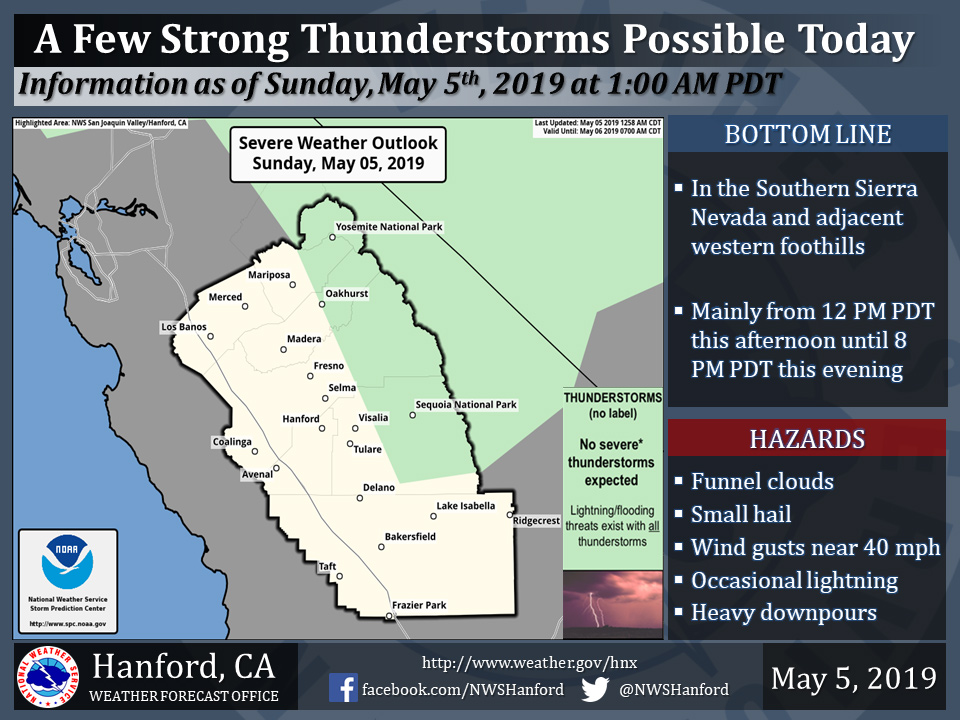
May 5, 2019 - The National Weather Service Hanford Office reports a few strong thunderstorms are possible in the Southern Sierra Nevada and adjacent foothills, primarily this afternoon and this evening.
Also a few strong thunderstorms are possible in the Southern Sierra Nevada and adjacent foothills, mainly Monday afternoon and Monday evening.
Funnel clouds, small hail, and wind gusts near 40 miles per hour are some of the hazards associated with strong thunderstorms.
In addition to dangerous cloud to ground lightning strikes, any thunderstorm can produce intense rainfall rates, leading to localized flooding.
Source: NWSArea Forecast Discussion National Weather Service San Joaquin Valley - Hanford CA 316 AM PDT Sun May 5 2019 .SYNOPSIS... Low pressure will move into the region Today and Monday bringing cooler temperatures and unsettled weather. A cold, deep trough of low pressure will then set up over the region for continued cooler than normal and unsettled weather. && .DISCUSSION... Upper Low over the Eastern Pacific continues to track eastward and headed toward Central California. While still some 300 miles offshore, short range model proggs have the upper low reaching the West Coast around Noon today with precipitation possible during the afternoon hours. In the meanwhile, a southwesterly flow aloft will keep morning conditions on the mild side as Valley temperatures stay in the 50s and 60s this morning. Yet, after have several dry days with only mountain convection, change in the weather will be ushered in during the next 24 hours as the upper low makes landfall during the day. As the upper low approaches the West Coast, uncertainty is high on the coverage of the precipitation and possible thunderstorm activity today. Yet, confidence is also high that precipitation will occur today due to the dynamic lift and moisture surge of the approaching disturbance. Just not sure if disturbance will have enough energy to produce precipitation over the Valley locations. At the moment, will keep the Valley in a very slight risk for precipitation and possible thunderstorm activity. Orographic lift will provide the mountains and foothills with addition support to generate afternoon thunderstorms. While precipitation may start as soon as 1 to 2 PM PDT, bases on ensembles plume diagrams, best difluent flow lift moves into Central California closer to 5 PM PDT this afternoon. Therefore, will trend toward better precipitation potential during the day as thunderstorm coverage increases during the evening hours. While the potential for continued thunderstorm treat could continue pass midnight, models do shift the upper low slightly south which may reduce the precipitation coverage before daybreak on Monday. For the moment, will maintain wording of widespread convection during the early Monday morning period and reduce the coverage after day-break. Upper low does manage to shift further into Southern California by Monday afternoon. Yet, this will only lower the coverage of convection to the Mountainous regions and possibly the eastern portions of San Joaquin Valley over Tulare and Kern Counties. Due to the slow movement of the Upper Low, enough lift will exist over Central California to provide the area (mostly mountains) with enough moisture, lift and instability to generate isolated thunderstorms through at least Tuesday. While the potential for thunderstorm greatly diminishes toward Wednesday, enough convergence exist to at least generate an air-mass thunderstorm over two. Its during the latter part of the week that things get interesting. Models continue to show high uncertainty in the development of a disturbance dropping into California from the north. Currently, the ECMWF is the only one that develops a closed low over California that would provide enough energy for any possible precipitation. Model blend is picking up the precipitation during the later periods and mostly over the mountains. Therefore, will not terminate the precipitation over Central California through at least the end of the week. Storm Prediction Center has the mountains and foothills under a thunderstorm treat through at least Mid-week which agrees with local analysis. Even with very high uncertainty going into next weekend, some consensus is pointing toward an easterly flow aloft that may help dry out the district. The easterly flow aloft will be followed by a tilted ridge pattern which may re-enforce the dry pattern over Central California and finally end the string of precipitation over the region.

