


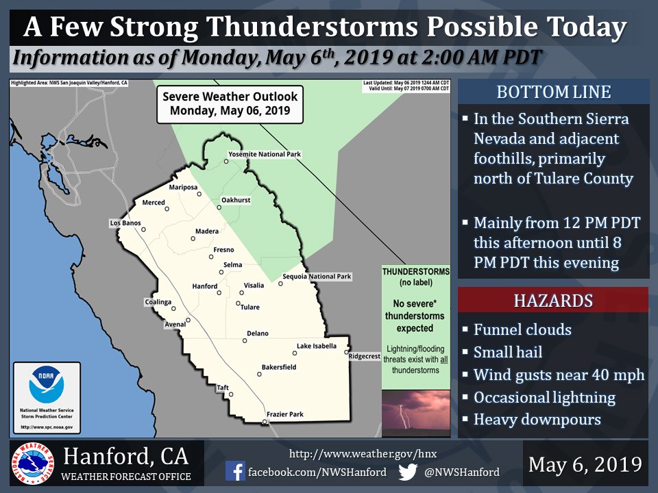
May 6, 2019 - The National Weather Service Hanford Office reports a few strong thunderstorms are possible in the Southern Sierra Nevada and adjacent foothills this afternoon and this evening, mainly north of Tulare County.
Funnel clouds, small hail, and wind gusts near 40 miles per hour are some of the hazards associated with strong thunderstorms.
In addition to dangerous cloud to ground lightning strikes, any thunderstorm can produce intense rainfall rates, leading to localized flooding.
Area Forecast Discussion
  National Weather Service San Joaquin Valley - Hanford CA
  250 AM PDT Mon May 6 2019

  .SYNOPSIS...
  A low pressure system in the vicinity of Southern California will
  be responsible for cooler afternoon temperatures and unsettled
  weather over the Southern Sierra Nevada and adjacent foothills
  today through Tuesday. The greatest potential for rain this week
  in the San Joaquin Valley should be Thursday afternoon through
  Friday afternoon.

  &&

  .DISCUSSION...
  A low pressure system is located just off the coast of Santa
  Barbara County. This storm system is responsible for gusty
  southwest to west winds in the west side hills, where a Wind
  Advisory is in effect until 4 AM PDT. Most high resolution
  computer model guidance indicates that wind gusts will decrease
  this morning, before increasing once again late this afternoon.
  The low pressure system just offshore of Santa Barbara County will
  move southeastward down the south coast of the Golden State today,
  before progressing eastward across Southern California tonight.
  High temperatures this afternoon throughout Central California
  will be five to ten degrees below normal for this time of year.
  Gusty winds will develop late this afternoon in the Kern County
  mountains and desert, as well as in the west side hills. These
  gusty winds will persist into early tonight. A Wind Advisory may
  be required for these areas from late this afternoon into early
  tonight. Isolated thunderstorms cannot be ruled out in the
  Southern Sierra Nevada and adjacent foothills this afternoon and
  this evening.

  The aforementioned low pressure system will move eastward across
  the Desert Southwest Tuesday and Tuesday night. Wrap around
  atmospheric moisture will be responsible for a continued
  convective threat in the Southern Sierra Nevada and adjacent
  foothills Tuesday afternoon and Tuesday evening. Gusty winds are
  likely to develop in the Kern County mountains and desert late
  Tuesday afternoon, persisting into early Tuesday night. A trough
  of low pressure aloft will dig southwestward across the Great
  Basin Wednesday through Thursday. An area of low pressure may
  develop in the base of this upper-level trough Thursday night in
  the vicinity of Central California. This area of low pressure will
  meander around Southern California Friday into the upcoming
  weekend. The best chance for rainfall in the San Joaquin Valley
  will occur Thursday afternoon through Friday, when this
  atmospheric impulse is closest to Central California.
Source: NWS

