


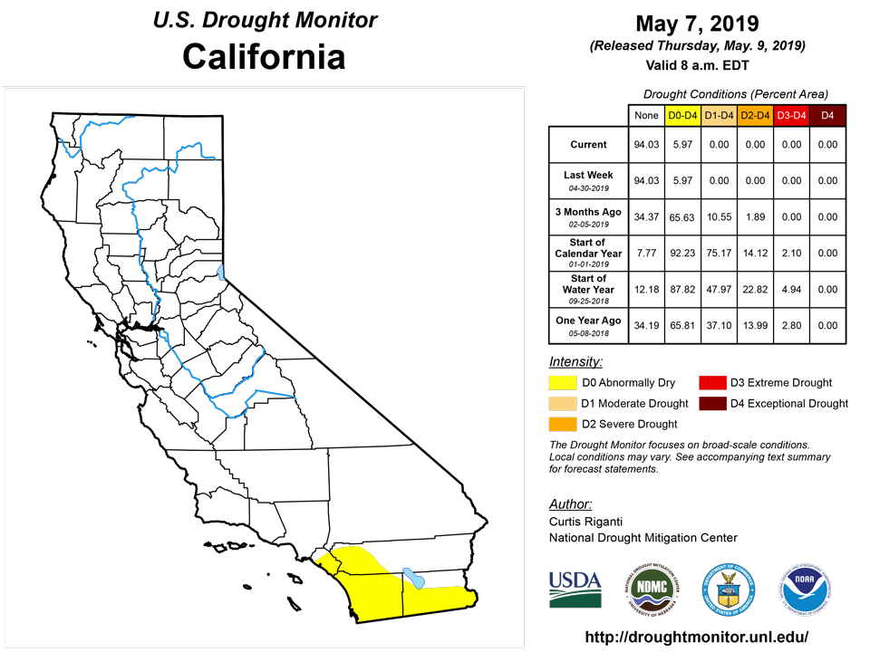
California and National Drought Summary for May 7, 2019
Summary
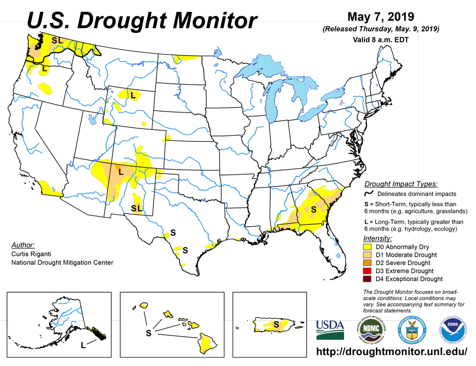
May 9, 2019 - A large portion of the lower 48 states remains free of drought or abnormal dryness this week, including the entire Northeast and Midwest regions. Moderate drought coverage shifted in Georgia in response to precipitation patterns over the past week. Areas of short-term moderate drought were removed in Texas, where widespread moderate to heavy precipitation fell. Severe drought in northwest New Mexico was reduced in coverage because of improved short-term conditions, though some long-term precipitation deficits remain in the area. Moderate drought was added in western Washington because of worsening short- and long-term precipitation deficits and low streamflow. Widespread improvements to the drought depiction were made in Hawaii. The northern part of the drought area in southeast Alaska improved some, while severe drought expanded slightly to the south of its position last week in southeast Alaska. No changes were made this week in Puerto Rico.
Northeast
The Northeast remained free of drought or abnormal dryness this week, as light to moderate precipitation overspread much of the region.
Midwest
The Midwest also remained free of drought or abnormal dryness this week, with Illinois and Missouri receiving widespread moderate to heavy rainfall amounts. Precipitation in the short term in western Iowa has been rather sparse, though this has not led to the development of abnormal dryness.
Southeast
This week, moderate drought shifted in coverage in parts of south-central and southwest Georgia. The changes were made where precipitation drought indicators shifted in response to precipitation amounts over the last week. Abnormal dryness was removed along the Florida east coast where precipitation alleviated short-term drought conditions, though some deficits remain in the long term.
South
Widespread improvements were made in Texas this week in areas that received moderate to heavy precipitation, such that no areas of moderate drought remain. With the heavy precipitation, the Brazos River is running high in north-central Texas, and minor to moderate flooding is a concern in parts of Texas. A small area of abnormal dryness expanded from northeast New Mexico into the Texas and Oklahoma panhandles, where soil moisture has lessened in response to lower short-term precipitation and frequent hot and windy conditions.
High Plains
A small area of abnormal dryness developed in southwest Nebraska, far northwest Kansas, and a small part of northeast Colorado because of short-term precipitation deficits and low streamflow in the area. Abnormal dryness also has developed as a result of short-term precipitation deficits in the Laramie Range in Wyoming. In North Dakota, abnormal dryness was extended slightly eastward in response to short-term precipitation deficits. Meanwhile, abnormal dryness in western North Dakota was removed in areas where long-term drought conditions had improved. Very wet conditions have continued in Kansas, and flooding is taking place in south-central Kansas.
West
Long-range drought conditions continued to improve in northwest New Mexico where vegetation is beginning to recover. Thus, severe drought coverage was reduced here, and it remains the only area of severe drought in the lower 48 states. Moderate drought developed in western Washington, and abnormal dryness also expanded here, in response to worsening short- and long-term precipitation deficits, low streamflow, and low soil moisture in some areas. Abnormal dryness developed in the Wind River Range in Wyoming and in the Jackson area in Wyoming. Abnormal dryness was removed in northeast Montana, where long-term precipitation deficits had improved.
Alaska, Hawaii, and Puerto Rico
Widespread improvements to the drought depiction were made in Hawaii in areas where recent rainfall improved conditions. However, severe drought continues on the leeward areas of Kauai, Maui, and the Big Island. The northern part of the drought area in southeast Alaska improved some, while severe drought expanded slightly to the south of its position last week in southeast Alaska. Drought conditions in the short term have lessened, so the area is now depicted as long-term drought. Impacts in Petersburg and Juneau have lessened, while Prince of Wales, Ketchikan, and Metlekatla are still primarily on diesel power because of low hydropower output. No changes were made this week in Puerto Rico.
Pacific Islands
The weather pattern during this USDM week (5/1/19-5/7/19) consisted of (1) a surface trough across western to central Micronesia with a couple circulations/weak tropical disturbances embedded within it, one in the western end near Yap and Koror and the other in the eastern end between Chuuk and Kosrae; (2) converging trade winds over Kosrae State to the southern Marshall Islands; (3) dry trade winds across northern Micronesia; and, south of the equator, (4) a surface trough which oscillated across the Samoan Islands, producing a wet week for American Samoa.
Dry conditions persisted across the Mariana Islands during the USAPI USDM drought week of 7 May 2019, with all three stations (Guam, Saipan, and Rota) receiving less than half their weekly minimum of 1 inch of precipitation to meet most water needs. The station with the least precipitation total was Guam, which only had 0.09 inches for the week, while Saipan and Rota had 0.43 and 0.16 inches, respectively. According to the Drought Information Statement issued on 2 May 2019 by the NWS Tiyan Guam, an increase in the risk of grass fires in Guam as well as the reduction of Saipan’s fresh water resources could be a problem in the next couple of weeks if dry conditions prevail. There was no change to the drought category for the stations in the Marianas, with extreme drought (D3-S) at Guam and Rota and exceptional drought (D4-S) at Saipan.
Palau was also dry this week, receiving only 0.94 inches of rain. This value is 1.06 inches less than their weekly minimum of 2 inches to meet most water needs. Palau has not met its monthly minimum of 8-inches since the start of the year. For this reason, severe drought (D2-S) continues across Palau.
Several stations across FSM had a wet week, with Kosrae having the highest precipitation total at 14.45 inches, exceeding the monthly minimum of 8 inches by 6.45 inches in just one week. Other notable precipitation totals were reported in Kapingamarangi (8.79 inches) and Pingelap (7.82 inches), which had more than the monthly minimum of 8 inches. Due to the very wet conditions experienced this week, no drought or dryness (D-Nothing) remained in all three stations. Yap and Woleai also had wet conditions during the week at 2.56 and 2.27 inches, respectively, exceeding their weekly minimum of 2 inches. Even though this was a wet week, the last several months have been extremely dry for both stations. Yap in particular has experienced extremely dry conditions since February 2019, with monthly precipitation totals between 1.57 inches to 2.77 inches, which is much less than the ideal 8 inches of precipitation. Moderate drought (D1-S) remained in Woleai while Yap remained in extreme drought (D3-S). Chuuk, Pohnpei, Lukunoch, and Nukuoro had dry conditions during the week, with Chuuk receiving the least precipitation total at 0.01 inch. Since last two months Chuuk had less than their minimum of 8 inches and this week almost no rain at all, the drought classification was downgraded from no drought (D-Nothing) to abnormally dry (D0-S). Nukuoro had a total of 1.34 inches of rain this week, which is less than their 2-inches weekly minimum, however, no drought (D-Nothing) remained since precipitation totals for the past several months have surpassed the 8-inches mark by, in some instances, nearly twice as much. Similarly, Lukunor and Pohnpei’s monthly precipitation totals were above the 8-inches mark the last two months and thus drought classification remained at no drought (D-Nothing) even though this week the precipitation total were only 0.48 inches (2 days missing data) and 0.42 inches, respectively, much less than their 2-inches weekly minimum. Fananu and Ulithi had missing data and thus no analysis was performed for these stations.
Most of the Marshall Islands had dry conditions for the week; however, Majuro, Jaluit, and Mili were the only stations that had wet conditions, reporting a total of 3.96, 2.45 and 2.34 inches of rain, respectively, which is more than their 2 inches weekly minimum to meet most water needs. This was Jaluit and Mili’s first wet week since early April, while this was Majuro’s first wet week since the end of March. However, since Jaluit and Mili had really dry April and May, abnormal dryness (D0-S) persists this week. Beneficial rain fell over Majuro this week, helping improve reservoir levels from 65.5% at the end of April to 75.9% by 7 May 2019. According to the Drought Information Statement issued on 2 May 2019 by the NWS Tiyan Guam, the dry conditions led the development of fires across Majuro. Due to the dry conditions since January 2019, the impacts, and the fact that reservoir levels are still below the critical 80% threshold, Majuro’s extreme drought (D3-S) classification did not change this week. For the remaining five Marshall Island stations, three (Kwajalein, Utirik, and Wotje) had little to no rain. Utirik and Wotje had no rain this week, while Kwajalein reported receiving 0.64 inch of rain—much less than their 2.0 inches weekly minimum. Due to persistence of extreme dry conditions (since autumn 2018), Wotje’s drought category was changed to exceptional drought with short and long-term impacts (D4-SL). Kwajalein and Utirik’s drought classifications remained the same this week as extreme drought (D3-S) and exceptional drought (D4-SL), respectively. Allinglapalap’s precipitation total of 1.15 was below the weekly minimum and its drought classification remained at moderate drought (D1-S).
Pago Pago reported receiving over double its weekly minimum at 5.16 inches during this USAPI USDM drought week. Due to the very wet conditions, no drought or dryness (D-Nothing) classification was unchanged for Pago Pago.
Looking Ahead
Widespread moderate to heavy rain is forecast to continue over the next several days over parts of the south-central United States. The highest rainfall amounts are forecast to occur in southeast Texas, Arkansas, and Louisiana. Precipitation is also forecast in parts of New Mexico that are still experiencing drought. Moderate precipitation amounts are predicted to fall across much of the Northeast and the Upper Midwest. Dry weather is forecast in the Pacific Northwest. Primarily warm weather is forecast in the Northwest, while much of the Plains is expected to be cooler than normal, with moderating temperatures expected early next week.
Author(s):
Curtis Riganti, National Drought Mitigation Center
Ahira Sanchez-Lugo, NOAA/NCEI
Dryness Categories
D0 Abnormally Dry—used for areas showing dryness but not yet in drought, or for areas recovering from drought.
Drought Intensity Categories
D1 Moderate Drought
D2 Severe Drought
D3 Extreme Drought
D4 Exceptional Drought
Drought or Dryness Types
S Short-Term, typically less than 6 months (e.g. agricultural, grasslands)
L Long-Term, typically greater than 6 months (e.g. hydrologic, ecologic)
Source: National Drought Mitigation Center

