


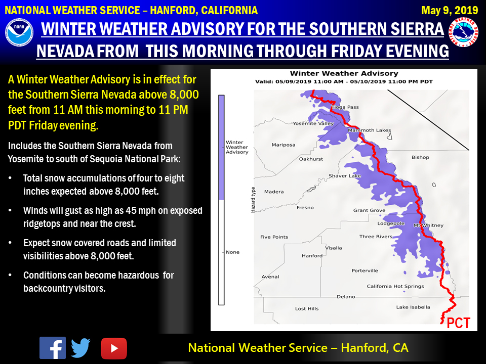
May 9, 2019 - The National Weather Service reports a Winter Weather Advisory is in effect for the Southern Sierra Nevada from Yosemite to south of Sequoia National Park above 8,000 feet from 11:00 A.M. this morning through 11:00 P.M. Friday.
Motorists should anticipate additional snow covered and closed roads above 8,000 feet.
If you plan to travel in the mountains, remember to carry tire chains, plenty of food, a good deal of water, and warm clothing in your vehicle.
Visitors to the Sierra backcountry can expect adverse weather conditions with the additional accumulating snowfall and gusty winds.
For information on road conditions, including closures or delays, call Caltrans at 1-800-427-7623 or visit http://www.dot.ca.gov/cgi-bin/roads.cgi.
Area Forecast Discussion
  National Weather Service San Joaquin Valley - Hanford CA
  345 AM PDT Thu May 9 2019

  .SYNOPSIS...A low pressure system will drop southward from the
  northern Rocky Mountain region into our area by this evening and
  bring unsettled showery conditions to our area by this afternoon
  and much cooler temperatures by Friday. Thunderstorms will be
  possible across our area today and again on Friday.

  &&

  .DISCUSSION...Upper shortwave currently dropping southward through
  southern NV has brought some mid/high clouds to our area
  overnight. These clouds are continuing to push southward and will
  be out of our area by later this morning as the shortwave moves
  into northern AZ. A dry northerly flow will prevail over our area
  today and once again a mostly sunny morning is in store for our
  area today and temperatures will be near seasonal normals.

  Meanwhile, an upper low center over the northern Rocky Mountain
  region is progged to drop southwest toward central CA today. The
  approaching low will destabilize the atmosphere over our area by
  late this afternoon providing for increased chances across the
  mountains and Kern Deserts by this afternoon and into the San
  Joaquin Valley by this evening. Isolated thunderstorms will be
  possible throughout our area by late this afternoon as the 06Z WRF
  is indicating LI`s between -4 DEG C and -1 DEG C and CAPES
  between 800-1200 J/KG across the San Joaquin Valley with higher
  amounts over the mountains. RH progs are indicating that this low
  is moisture deficient and any precipitation over our area will be
  more dependent on afternoon and evening convection. QPF amounts
  will be very difficult to pinpoint due to the convective nature of
  the precipitation that is expected, but locally heavy rainfall is
  possible in stronger thunderstorms this evening. The low is
  progged to move over our area tonight then drop southwest to off
  the Socal coast on Friday providing for increased clouds and
  unseasonably cool temepratures on Friday as well as a
  continuation of unsettled weather conditions through Friday with
  the likelihood of showers remaining high tonight and Friday.
  Isolated thunderstorms will once again be possible throughout our
  area Friday afternoon and evening. Any thunderstorms that develop
  today and Friday have the potential to produce heavy rain,
  dangerous lightning, gusty and erratic winds, as well as small
  hail.

  In addition, snow showers will be likely above 8000 feet in the
  Southern Sierra Nevada. Have issued a Winter Weather Advisory for
  elevations above 8000 feet from midday today through Friday
  evening as winter weather becomes less frequent this time of the
  year. Many locations above 8000 feet are expected to pick up
  between 4 and 8 inches of now snow by Friday evening with locally
  higher amounts possible near ridge tops. Below the snow line,
  hydrological concerns might become an issue in the southern Sierra
  Nevada and adjacent foothills tonight and Friday as heavier
  showers could combine with snowmelt runoff.

  The low is progged to drift eastward into northern Baja by
  Saturday, but the models often have problems with cutoff lows so
  am not very confident of that happening. The upper flow will be
  east to northeast this weekend, but wrap around moisture will
  provide for a continuation of showery weather over the mountains
  and chances of showers over the Kern County Deserts and southern
  and eastern portions of the San Joaquin Valley.

  The medium range models are indicating the low moving east along
  the US/Mexico border on Sunday and Monday which would give way to
  a clearing, drying and warming trend. However, am not too
  confident on that happening as cut off lows seem to have a mind
  of their own. Am trending temperatures upward, cloud cover
  downward and showers less prevalent each day Sunday through
  Tuesday, but confidence is low. A Pacific trough is progged to
  reach the western Conus coast by the middle of next week which may
  bring another round of cooler temperatures and unsettled weather
  to our area.
Source: NWS

