


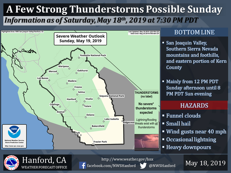
Thunderstorms Possible in Mariposa County, Oakhurst and Yosemite National Park Today
May 19, 2019 - The National Weather Service Hanford Office reports a few strong thunderstorms are possible Sunday afternoon and evening in the Southern Sierra Nevada, Southern Sierra Nevada foothills, and eastern portion of Kern County.
Funnel clouds, small hail, and wind gusts near 40 miles per hour are some of the hazards associated with strong thunderstorms.
In addition to dangerous cloud to ground lightning strikes, any thunderstorm can produce intense rainfall rates, leading to localized flooding.
Area Forecast Discussion
  National Weather Service San Joaquin Valley - Hanford CA
  401 AM PDT Sun May 19 2019

  .SYNOPSIS...Cool and unsettled weather will continue over
  the central California interior for the next several days.

  &&

  .DISCUSSION...A storm system that is currently centered off the
  northern California coast has brought generous precipitation to
  much of the CWA during the past 12 hours. Observations from our
  vast network of mesonet data sites indicate that snow is likely
  falling above 5500 feet with rain at lower elevations. A cold
  front will soon exit south and east of our CWA.

  Our focus now will shift to the cold core low currently off the
  northern California coast. As this system drifts inland today,
  it will put our CWA in the left front quadrant of the upper level
  jet and in an increasingly unstable atmospheric environment. Model
  soundings indicate the presence of strengthening vertical wind shear
  in the lowest 3000 feet by this afternoon. Cooling aloft combined
  with impressive CAPE and surface heating will combine to produce
  isolated strong thunderstorms over the central California interior
  by mid to late afternoon. Although a few thunderstorms could spawn
  funnel clouds, most will probably be equipped with gusty winds,
  briefly heavy rain and possibly small hail into early this evening.
  Meanwhile, periods of heavy snow will continue over the higher
  elevations of the Sierra.  The only part of our CWA that will be
  spared heavy rainfall will be in the Kern county desert. In this
  region, post frontal winds will gust to 45-55 mph through early this
  evening.  We`ve launched a wind advisory accordingly for these
  zones.

  Otherwise, today will be an exceptionally cool day for the middle of
  May. Thermometer readings will be no higher than the mid 60s in the
  San Joaquin Valley this afternoon. It will be harshly cold for anyone
  camping or hiking in the high Sierra this weekend. Temperatures this
  afternoon will be no higher than the 30s at the 8,000 foot level and
  wind chill temperatures will only be in the teens! These are
  extraordinary weather anomalies for the middle of May. In Fresno and
  Bakersfield, today could end up as the coolest May 19th ever and new
  records could become established for greatest 24 hour rainfall.

  Shower activity will diminish later this evening and overnight tonight
  as the cold core low exits east of our CWA. Snow will taper to flurries
  in the Sierra above 5,000 feet and westerly winds will slowly abate in
  the Kern county mountains and desert. Otherwise, an unseasonably chilly
  air mass will linger in the wake of this storm system tonight. Temperatures
  will bottom out in the 40s over much of the San Joaquin Valley and the
  Kern county desert by late tonight. A dry northwesterly flow aloft will
  reside over the Golden State Monday with little more than a few residual
  showers over the mountains. In the meantime, another cold storm system
  will be barreling southeastward toward central California.  While this
  next storm system could bring a few renegade showers into the CWA as
  early as Monday night, the bulk of the precipitation it brings will be
  on Tuesday and in the form of higher elevation snow over the Sierra and
  rain in the lower elevations. Like the current storm, the cold core nature
  of the next storm will bring a renewed threat of afternoon and early
  evening thunderstorms Tuesday. Precipitation should diminish over most
  of the CWA by Tuesday night as this system exits southeast of our CWA.
  There is a concern that showers may redevelop over the Sierra Wednesday
  and again Thursday as this storm system stalls over the Great Basin. A
  northeasterly flow aloft during this time could even carry a few late day
  showers into the east side of the San Joaquin Valley, especially Thursday.

  The longer range models show little change in the overall pattern through
  day 7. That being said, our spell of unseasonably cool and unsettled
  weather will most likely continue into Memorial Day weekend. The GFS
  actually brings another cold core low into the Golden State Friday then
  anchors it near the central California coast next weekend. If this happens,
  showers could occur each and every day just about anywhere over the
  central California interior Friday through next Sunday, especially over
  the mountains. While this goes strongly against climatology, we can`t
  really put much confidence in the extended forecast period.  One thing
  we can be more certain of are temperature trends in the 5 to 7 day period
  which are likely to continue running several degrees below normal.
Source: NWS

