


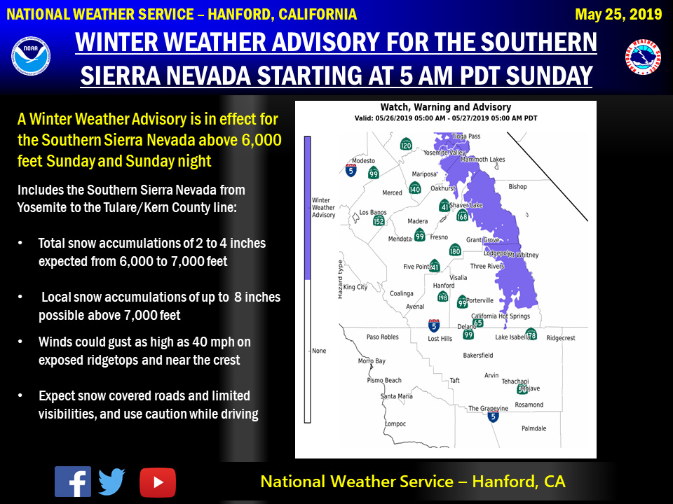
May 25, 2019 - The National Weather Service Hanford Office reports a Winter weather advisory is in effect for the Southern Sierra Nevada above 6,000 feet from 5:00 AM PDT Sunday morning until 5:00 AM PDT early Monday morning.
Snow levels will fall to as low as 5,500 feet Sunday night.
The majority of this snow will fall Sunday afternoon.
Gusty winds are possible on exposed ridgetops and near the crest.
Motorists should anticipate travel difficulties, delays and slick, hazardous road conditions, as well as the potential for road closures above 6,000 feet.
If you plan to travel, consider alternate strategies.
If you must travel, remember to carry tire chains, plenty of food, a good deal of water, and warm clothing in your vehicle.
For information on road conditions, including closures or delays, call Caltrans at 1-800-427-7623 or visit http://www.dot.ca.gov/cgi-bin/roads.cgi.
Winter Weather Advisory
URGENT - WINTER WEATHER MESSAGE
National Weather Service Hanford CA
306 AM PDT Sat May 25 2019

Central Sierra-North Kings River-Sequoia Kings-
Including the cities of Devils Postpile, Florence Lake,
Lake Thomas Edison, Tuolumne Meadows, Shaver Lake, Lodgepole,
and Grant Grove
306 AM PDT Sat May 25 2019

...WINTER WEATHER ADVISORY IN EFFECT FROM 5 AM SUNDAY TO 5 AM PDT
MONDAY ABOVE 6000 FEET...

* WHAT...Snow expected above 6000 feet. Total snow accumulations
  of 2 to 4 inches expected above 6000 feet. Local heavier amounts
  possible of up to 8 inches above 7000 feet. Winds could gust as
  high as 40 mph.

* WHERE...Central Sierra, North Kings River and Sequoia Kings.

* WHEN...From 5 AM Sunday to 5 AM PDT Monday.

* ADDITIONAL DETAILS...Plan on slippery road conditions.

PRECAUTIONARY/PREPAREDNESS ACTIONS...

A Winter Weather Advisory for snow means periods of snow will
cause primarily travel difficulties. Expect snow covered roads
and limited visibilities, and use caution while driving.

The latest road conditions for the state you are calling from can
be obtained by calling 5 1 1.
Source: NWS

