


California and National Drought Summary for May 28, 2019
Summary
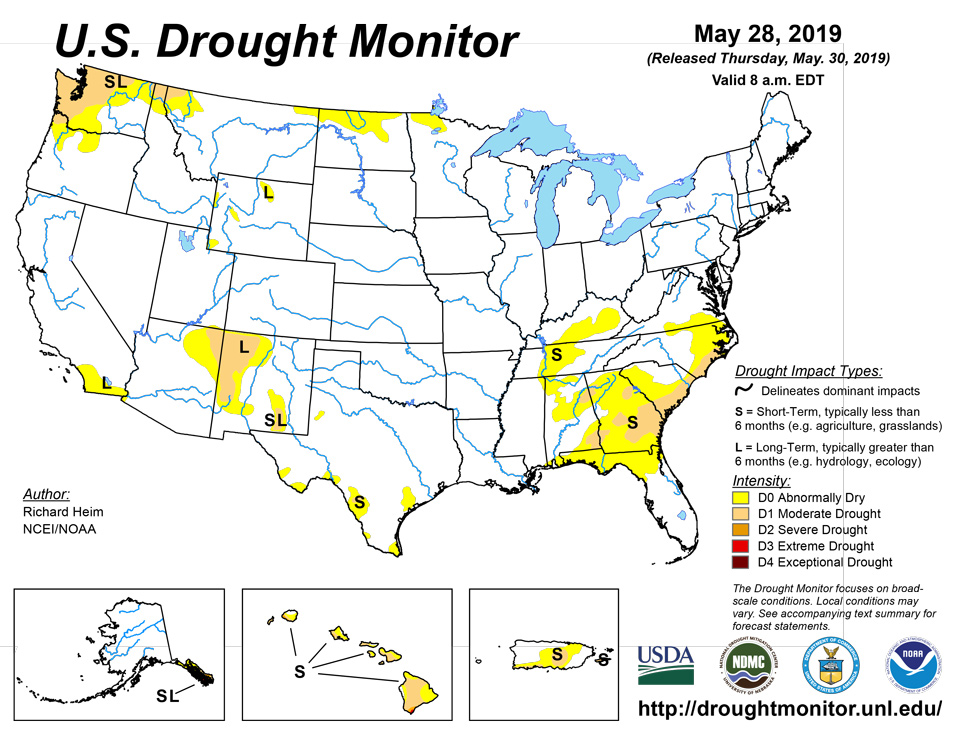
May 30, 2019 - During this U.S. Drought Monitor (USDM) week, a strong high pressure ridge was anchored over the southeastern contiguous U.S. (CONUS) while an upper-level trough dominated the West. This pattern set up a southwesterly flow across the central part of the country, which funneled moist and unstable air from the Gulf of Mexico into the Plains. Pacific weather systems moving in the jet stream flow plunged into the western trough, bringing precipitation and cooler-than-normal temperatures to much of the country from the Rockies westward. The weather systems intensified as they moved into the Plains, triggering another week of severe weather and heavy flooding rains. Two or more inches of precipitation occurred across the Plains to Midwest and in upslope areas of Montana and Wyoming, with locally 5 inches or more. Weekly precipitation was wetter than normal across much of the Southwest, and from much of the Great Plains to Great Lakes. Half an inch to locally 2 inches was observed from the central Appalachians to New England, but these amounts were mostly below normal. The week ended up drier than normal across western Washington, northern Idaho and northern Montana, southern Arizona, most of New Mexico, and central to southern Texas. The subtropical high kept the Southeast drier and warmer than normal, with record high temperatures reported. As a result of this weather pattern, drought contracted in Oregon, Wyoming, and the central Plains, but expanded in the northern Rockies, Texas, the Tennessee Valley, and the Southeast.
Northeast
This week was drier than normal for much of the Northeast, with dry areas developing over the last 3 months. Pockets in New England were nearing a 3-inch precipitation deficit over the last 90 days. While the region is currently free of drought or abnormal dryness on the USDM map, D0 could be added in the coming weeks if below-normal precipitation persists.
Southeast
The subtropical ridge left most of the Southeast with no rainfall this week and several record maximum temperatures. The hot weather increased evaporation and dried soils. Only isolated areas, mostly in the Carolinas and Florida, had any rain at all and amounts were mostly less than half an inch. D0-D1 expanded from northern Florida to southern Virginia. Dry and hot conditions prevailed for the last 2 to 4 weeks, with below-normal precipitation noted in many areas for the last 3 months. Some of the drought indicators, especially the Standardized Precipitation Index (SPI), Evaporative Drought Demand Index (EDDI), and soil moisture indices, indicated D2 was imminent, but D2 was not added this week. May 26 U.S. Department of Agriculture (USDA) reports indicated that 77% of the topsoil moisture in Georgia was short or very short (dry or very dry), up from 41% last week. Other states had similar increases: Alabama increased from 12% to 47%, Florida increased from 42% to 64%, North Carolina increased from 29% to 60%, South Carolina increased from 48% to 86%, and Virginia increased from 3% to 26%. Subsoil moisture conditions were just as bad, with short to very short subsoil up to 33% of Alabama, 52% of Florida, 55% of Georgia, 14% of Mississippi, 50% of North Carolina, and 76% of South Carolina. According to media reports, Brunswick County in southeastern North Carolina issued a notice to "use water wisely" due to developing drought conditions and increased demand, and was considering instituting water conservation measures. Nearby Pender County restricted water use due to an ongoing water shortage emergency in southeastern parts of the county caused by high demand, hot weather, and limits in their distribution system. In Georgia, reports from Coffee County included hay reserves disappearing, soils drying, and heat stress to crops; planting stopped on non-irrigated acres and irrigation was turned on for irrigated acres.
South
Precipitation amounts in the South ranged from zero in parts of Texas, Louisiana, Mississippi, and Tennessee, to over 5 inches in northern Oklahoma. D0 expanded in central Tennessee where 90-day precipitation deficits were noteworthy, pockets of D0 expanded or were introduced in southern Texas along the Rio Grande or along the coast, and D1 was added to Zavala County in Texas where dryness was evident for the last 7 days to 6 months. According to USDA reports, 21% of the topsoil moisture in Tennessee was short or very short, up from 3% last week. The last couple weeks have been very dry, hot, and windy in southern Texas as the subtropical ridge continued to build and dry out the atmosphere. There have been reports of significant evaporation of Cameron County retention ponds with fields and lawns showing some browning. Some producers in Dimmit County, Texas were hauling water and supplemental feeding in some areas.
Midwest
Precipitation this week in the Midwest ranged from widespread 2+ inches in the western portions to less than an inch in the eastern portions and a tenth of an inch or less along southern Kentucky. D0 expanded into Kentucky from Tennessee where 7-90 day precipitation deficits were significant, and a small area of D0 continued in northwest Minnesota. Otherwise, the Midwest region was devoid of drought or abnormal dryness. According to the USDA, short to very short topsoil moisture grew from 3% of Kentucky last week to 15% this week.
High Plains
The central to northern Plains received 2 or more inches of precipitation across a large area from Kansas to Wyoming and southern Montana, with 5 or more inches measured in Kansas and Nebraska. An inch to 2 inches occurred to the north and in parts of Wyoming, with less than a half inch measured in southwest Wyoming and northwest North Dakota to north central Montana. The precipitation deleted D0 in southwest Nebraska and D1 in the Big Horn Mountains of Wyoming and shrank the surrounding D0. But D0 expanded across the northwest corner of North Dakota into northeast Montana where 90-day precipitation deficits were notable. Windy conditions and sparse rain have dried soils in Daniels and Sheridan Counties in Montana, with fire risk increasing. Soils were drying in northern North Dakota and some sloughs and ponds had low water levels. An inch or more of rain this week prevented the expansion of D0 and addition of D1 in northern North Dakota this week, but it may be considered for next week.
West
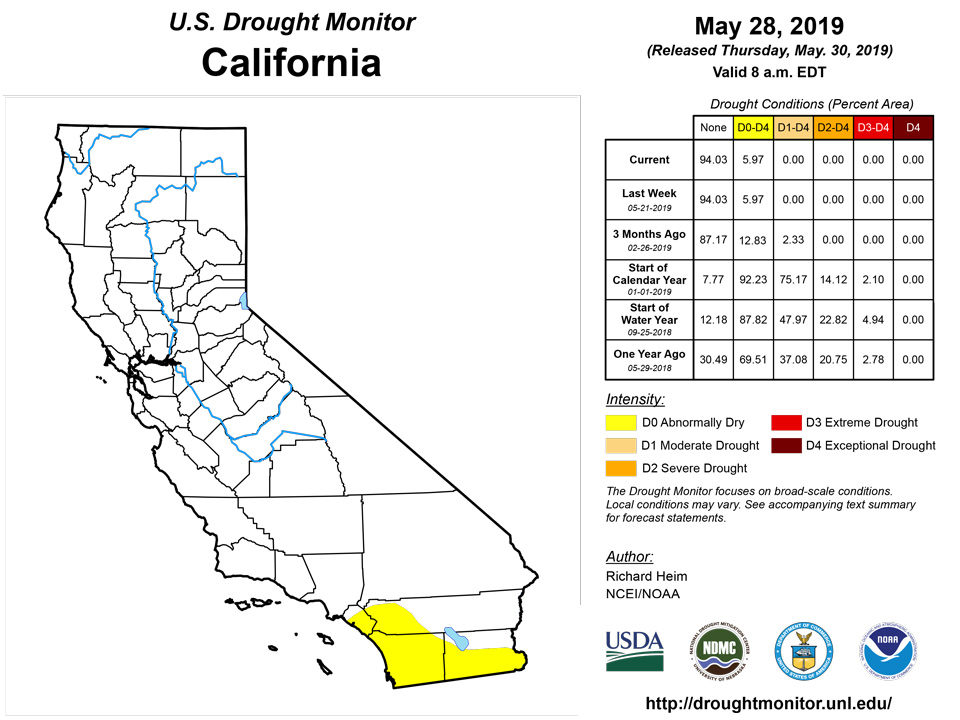
D0-D1 remained in parts of Arizona and New Mexico, and D0 remained in southern California, both reflecting long-term dryness which has built up over the last 5 to 6 years (and low reservoirs in southern California), and in Washington to northwest Oregon. Precipitation was above normal in southeast Oregon at most time scales, so the D0 there was deleted. But in western Washington to northwest Oregon, this week was dry and most of the last 1 to 2 years have been drier than normal, mountain snowpack was diminished from normal values for this time of year, and streamflow was much below normal to record low. D0-D1 here reflected these conditions for now, but D2 may be needed if conditions worsen. D0-D1 expanded in the Rockies of northeast Oregon, far northern Idaho, and northwest Montana where streamflow and precipitation and SPI values for the last 4 months were low.
Alaska, Hawaii, and Puerto Rico
In Alaska, the panhandle continued much drier than normal this week with the rest of the state having a mixed precipitation anomaly pattern, while temperatures were warmer than normal for most of the state. The USDM status remained unchanged for Alaska, with D0-D3 continuing in the panhandle.
Record warm maximum temperatures continued this week in Hawaii, with below-normal precipitation occurring at most of the stations. A small portion of the Big Island down near South Point continued to deteriorate. Ranchers reported little to no feed from their pastures. FSA reported around 90% loss of grass and one rancher indicated he's starting to sell off some of his herd. Pastures along the Hamakua slopes have been deteriorating. On Maui, the Department of Water Supply declared a Stage 1 water shortage for Upcountry Maui. On Oahu, the west side has been very dry, with the FSA reporting that their customers no longer have ranching operations in the area, and brush fire incidents were also on the rise recently in the west half of the island. As a result, D3 was added and D0-D2 expanded on the Big Island; D1-D2 expanded on Maui; D0 expanded on Molokai; D2 added to Oahu; and D0-D1 expanded on Kauai. Near normal rainfall occurred within the Kona Coffee Belt in the South Kona District, so D0-D1 contracted on the west side of the Big Island.
In Puerto Rico, it was wetter than normal in the northwest and southeast parts of the island and along most of the north coast, but drier than normal across the rest of the island and on Vieques Island. Four to more than 7 inches of rain fell on parts of the northeast, with mudslides and river flooding reported. But soils continued to dry out along parts of the southern coast to east-central interior regions. D0 was deleted from the northwest coast and interior D0-D1 were trimmed along their west and north edges. In the southwest, the northern edge of D0 was trimmed, but D1 expanded along the southwest coast.
Pacific Islands
The weather pattern during this USDM week (5/22/19-5/28/19) consisted of weak disturbances over central and eastern parts of the Federated States of Micronesia (FSM) with a surface trough from near the Marianas to the eastern FSM, and trade-wind convergence across southern parts of the Marshall Islands (RMI) and eastern parts of the FSM. Other surface troughs appeared then faded over various parts of Micronesia at different times, while a stationary front with upper-level trough hovered just west of the USAPI, and island convection from daytime heating generated rain over parts of the Marianas. A dry trade-wind regime maintained its grip where the convection and convergence were absent. Dry mid- and upper-level air dominated the Samoan Islands for much of the week. Satellite-based estimates of 7-day precipitation (QPE) showed areas of 1-4 inches of precipitation associated with the frontal system and trough along the northwestern edge of Micronesia, across the southeastern FSM and southern RMI associated with the disturbances and trade-wind convergence, and a few areas in northern Micronesia associated with transient troughs. Other parts of Micronesia had little to no precipitation indicated on the QPE. South of the equator, 2-4 inches of rain was indicated east and southeast of American Samoa, with areas of 1-2 inches just north of the Samoan Island chain, and little to no rainfall to the southwest.
Saipan and Rota, which are two of the three stations analyzed in the Mariana Islands, had precipitation totals that were less than half their weekly minimum of 1 inch at 0.23 and 0.20 inches, respectively. Meanwhile, Guam had wet conditions for the first time in at least 11 consecutive weeks, receiving 1.62 inches for the week ending May 28. All three stations remain in extreme drought (D3-S) since dry conditions have lingered for several months.
Less than 1 inch of rain was reported during this week in the Republic of Palau. The monthly total precipitation (as of May 28) was 6.14, which is 1.86 inches less than the ideal 8 inches to meet most water needs. May 2018 marks the fourth consecutive month that this station hasn’t met the monthly minimum threshold. For this reason severe drought (D2-S) remains this week.
Most stations across the Micronesia experienced a dry week, with Pingelap having no rain (3 days of missing data). Other stations with precipitation totals below the weekly 2-inches minimum include Yap (0.07”; 3 days of missing data), Pohnpei (0.13”, 3 days of missing data), Kosrae (1.01”; 3 days of missing data), Lukunoch (0.32”; 3 days of missing data), Nukuoro (0.94”; 3 days of missing data), and Woleai (0.02”; 1 day of missing data). Although this was a dry week, drought was not a concern in Pohnpei, Kosrae, and Pingelap since the past several weeks have been wet or the monthly totals surpassed the 8-inches threshold. Abnormally dry (D0-S) conditions persisted across Lukunoch and Nukuoro since precipitation totals have been below the weekly 2-inch minimum the last few weeks. Meanwhile, Yap and Woleai are in severe drought (D2-S) since dry conditions have affected these islands since the start of the year. Chuuk Lagoon (2.83”; 1 day of missing data), Fananu (2.30”; 1 day of missing data), and Kapingamarangi (2.42”; 5 days of missing data) were the only stations that had precipitation totals surpass the 2-inches weekly minimum. Although an analysis is typically not done for stations that have 4 days or more missing, an analysis was made for Kapingamarangi since it had surpassed the weekly minimum. Kapingamarangi has been very wet the last few months and there are no drought concerns for this island. However, Chuuk Lagoon and Fananu remain in severe drought (D2-S) due to persistent dry conditions. No data was available for Ulithi.
Precipitation totals during the week were less than half 1 inch across most of the Marshall Islands. The station with the least precipitation was Jaluit, reporting only 0.01 inch of rain. Ailinglapalap (0.20 inch), Majuro (0.30 inch; 2 days of missing data), Mili (0.30 inch; 2 days of missing data), Utirik (0.13 inch; 3 days of missing data), and Wotje (0.16 inch; 2 days of missing data) were among the stations that received little rain. Abnormally dry (D0-S) persisted across Ailinglapalap, Mili, and Jaluit as dry conditions affected the region this week. The lack of sufficient precipitation across Utirik and Wotje for the last several months leaves them in an extended period of exceptional drought (D4-SL). Majuro’s reservoir levels as of May 29 were at 81.1% of the maximum capacity of 36 million gallons and slightly above the critical 80% threshold. Although the monthly precipitation total is above the 8-inches threshold, Majuro has experienced dry conditions since January 2019 and thus moderate drought remains this week. Kwajalein was the only station that had precipitation totals above the weekly 2-inches minimum at 2.10 inches. The monthly total precipitation for May 2019 was 10.06 inches as of May 28, marking the first time since December 2018 that the precipitation total in Kwajalein has reached or surpassed the 8 inches monthly threshold. Kwajalein’s drought status was changed from severe (D2-S) to moderate (D1-S).
This was a dry week for Pago Pago, reporting only 0.58 inch of rain. However, the monthly precipitation total for May is nearly double the minimum of 8 inches at 14.62 inches. No drought exists in Pago Pago.
Looking Ahead
Next week (May 30-June 4), an upper-level weather system will move across the eastern CONUS while another takes up residence over the Southwest. The high pressure ridge over the Southeast gradually shifts to the Plains. During this process, fronts and low pressure systems will trigger heavy rains again across the Plains to Midwest, with 1 to locally over 3 inches progged from northern Texas to Illinois, and from Illinois to Pennsylvania. An inch or more of precipitation is expected over much of the Northeast. Little to no precipitation is forecasted for much of the Southeast, most of California, the western half of the 4 Corners States, western Oregon, much of Washington, the High Plains of Wyoming and Montana, most of North Dakota, and northern Minnesota. Above-normal temperatures will continue in the Southeast for much of this period, and spread from the Pacific Northwest into the northern and central Plains, while cooler-than-normal temperatures will linger in the Southwest and from the eastern Great Lakes to New England. For June 5-12, odds favor above-normal precipitation from the 4 Corners States to the southern Appalachians, eventually spreading across the Southeast; along most of the Mississippi River; and over the northern half of Alaska, including the panhandle. Statistical odds favor drier-than-normal weather over the Great Lakes to Northeast, from northern California to the northern High Plains, and over southwestern Alaska. Cooler-than-normal weather is expected across New Mexico to western Texas, over Washington State, from the Great Lakes to New England, and over central Alaska. There is a high probability for warmer-than-normal weather over the northern to central Plains stretching into California, over the Southeast stretching to the Gulf of Mexico coast and Mid-Atlantic coast, and over southern and northern Alaska.
Author(s):
Richard Heim, NOAA/NCEI
Ahira Sanchez-Lugo, NOAA/NCEI
Dryness Categories
D0 Abnormally Dry—used for areas showing dryness but not yet in drought, or for areas recovering from drought.
Drought Intensity Categories
D1 Moderate Drought
D2 Severe Drought
D3 Extreme Drought
D4 Exceptional Drought
Drought or Dryness Types
S Short-Term, typically less than 6 months (e.g. agricultural, grasslands)
L Long-Term, typically greater than 6 months (e.g. hydrologic, ecologic)
Source: National Drought Mitigation Center

