


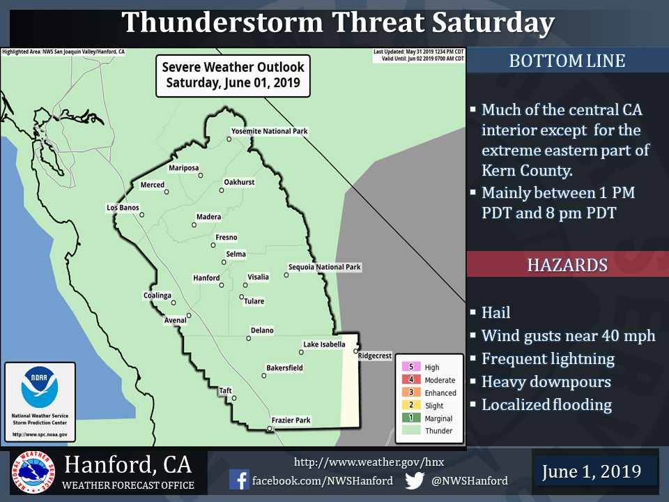
Thunderstorms Possible in Mariposa County, Oakhurst and Yosemite National Park Today
June 1, 2019 - The National Weather Service Hanford Office reports a few strong thunderstorms are possible in Central California during the afternoon and early evening hours Saturday.
In addition to frequent lightning, hail, heavy rain and gusty winds may accompany thunderstorms.
Any thunderstorm can produce intense rainfall which can lead to localized flooding.
Area Forecast Discussion
  National Weather Service Hanford CA
  409 AM PDT Sat Jun 1 2019

  .SYNOPSIS...
  An area of low pressure will move into Southern California
  today. This feature will influence the weather over our region
  through the weekend and bring a continued threat of afternoon and
  evening thunderstorms over mainly the mountain areas. WE are
  expecting a few thunderstorms to drift West in to the San Joaquin
  Valley late this afternoon and evening. Temperatures will remain
  generally seasonal for this time of year. Warmer than average
  temperatures are expected next week as high pressure builds over
  the area.

  &&

  .DISCUSSION...
  The upper level low pressure center that has brought unsettled
  weather to the region will slowly drift to the south of Kern
  County today. This will create more of an easterly flow across the
  Central CA Interior. Very impressive SB Cape values of 1000 to
  1500 j/kg are forecast across the Sierra this afternoon with
  another round of convection expected. We are becoming more
  concerned that the easterly flow will steer some of the storms
  into the SJV later this evening. HRRR simulated reflectivity
  product has been consistent with bringing heavy showers and
  thunderstorms into Tulare and eastern Kings county valley regions
  later today. WPC has the Sierra in an excessive rainfall outlook
  with PW`s approaching 1 inch in the Sierra. One factor with the
  low center being farther south will be the increased speed of the
  storms as they try to move out of the Sierra later today. Minor
  flooding is possible with the storms. Some storms may become
  severe later this evening.

  Another couple rounds of convection is expected on Sunday and
  Monday in the Sierra and possible into Kern County mountains.
  Upper level low pressure center slightly weakens and begins to
  open up into SRN CA by Monday evening. The track of the low
  continues southeast into AZ by Tuesday afternoon. EPAC ridging
  will build in over the area and bring some very warm temperatures
  across the region by mid week. Cant rule out an isolated shower
  along the crest with plenty of sublimation taking place. Most
  areas will see upper 90s on Wednesday, but an isolated triple
  digit is not out of the question.

  A trough will drop south from the PAC NW on thursday that will
  knock the temps down a few degrees. A more robust trough will plow
  south into the area on Friday with even more cooling expected for
  next weekend and dry SW flow aloft.
Source: NWS

