


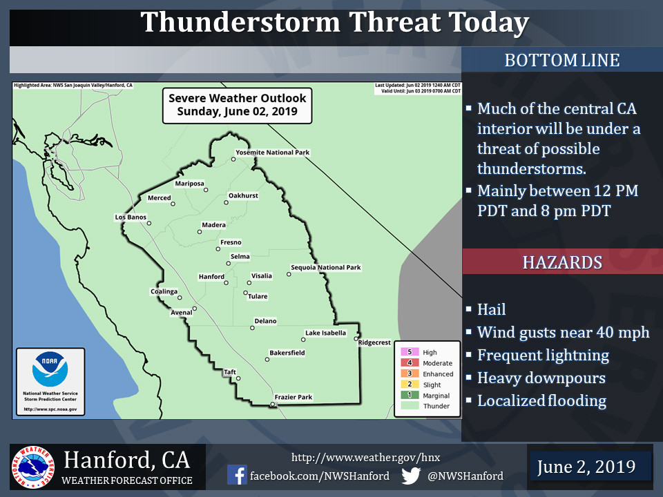
Thunderstorms Possible in Mariposa County, Oakhurst and Yosemite National Park Today
June 2, 2019 - The National Weather Service Hanford Office reports a few strong thunderstorms are possible in Central California during the afternoon and early evening hours today.
In addition to frequent lightning, hail, heavy rain and gusty winds may accompany thunderstorms.
Any thunderstorm can produce intense rainfall which can lead to localized flooding.
  Area Forecast Discussion
  National Weather Service Hanford CA
  317 AM PDT Sun Jun 2 2019


  .SYNOPSIS...
  An area of low pressure will remain over Southern California
  the next couple of days and look to influence the weather over
  our forecast area. This feature will continue to bring a continued
  threat of afternoon and evening thunderstorms over mainly the
  mountain areas through at least Tuesday. However, isolated storms
  are even possible over parts of the San Joaquin Valley and into
  the Kern County desert. Temperatures will remain generally
  seasonal for this time of year through Monday, and then warmer
  than average temperatures are expected as high pressure builds
  over the area.

  &&


  .DISCUSSION...
  This very stagnant pattern looks to continue at least through the
  next couple of days. The cutoff low that has increased the
  instability over the area the last couple of days is moving very
  little and will continue to sit over southern California through
  Tuesday. This will bring another day of showers and thunderstorms
  for especially the higher elevations of the Sierra. With the upper
  low circulation centered over central southern California the west
  side of the valley will have a northerly flow and the Sierra will
  have a more southerly flow. A few of the thunderstorms that
  develop over the Sierra could meander into parts of the San
  Joaquin Valley, such as what happened yesterday. Some of the
  storms could become strong but the main impact with slow storm
  movement will be heavy rainfall where the storms do develop. Of
  course lightning, hail, and gusty winds will also be threats.
  Near normal temperatures in the upper 80s to low 90s will be
  likely once again today. It will also continue to feel humid
  across many parts of the area as surface dew points are near 60
  degrees in the SJV. So even though temperatures are running near
  normal it will feel hotter than it actually is with the increased
  humidities.

  On Tuesday, weak ridging will move into the region and warm
  temperatures to above normal and begin to bring us a break in the
  action for at least the rest of the week. By next weekend another
  trough will drop southward from the Pacific Northwest and once
  again destabilize things. At this time, guidance has the trough
  just skirting our area to the north but would not be surprised if
  the trough moves a bit further south into central California. Even
  if the trough does stay further north there will be increased
  chances for afternoon showers and thunderstorms over the Sierra
  crest. Now with meteorological summer officially here as of
  yesterday temperatures are looking more seasonable, which
  depending on who you ask is a bit of a shame. I guess it has to
  come sooner or later. I prefer the latter of the two, but have to
  admit we have been spoiled this year.
Source: NWS

