


Temperatures slightly above normal, mainly across inland areas.
Near to slightly below normal number of summer thunderstorms outside the deserts.
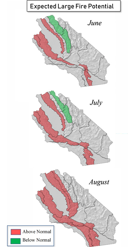
Large fire potential trending above normal this summer in the foothills and inland valleys due to tree mortality.
Greatest large fire potential may be in the Sierra Foothills and inland areas of Monterey and San Luis Obispo Counties the next 4 months.
Weather Discussion
June 3, 2019 - May was yet another anomalously cool and wet month as several cutoff storm systems moved past the state. During what is normally a dry month that precipitates a spike
 in grass fire activity, the upper air pattern produced temperatures which averaged 6-8 degrees below average the past 30 days. Los Angeles as well as many long-time stations recorded one of their coolest May’s on record. The streak of cool weather was further underscored during the Memorial Day weekend when many stations recorded highs 15-20 degrees below average.
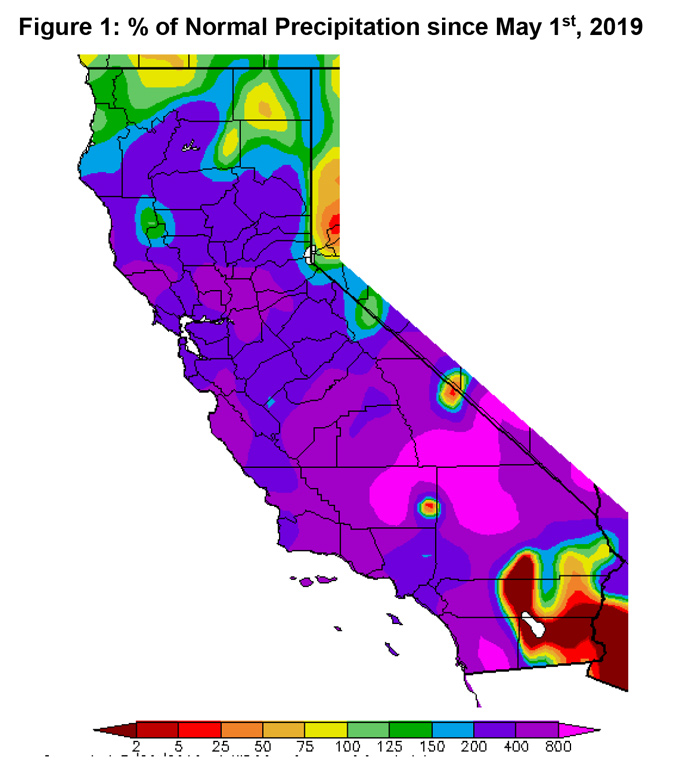
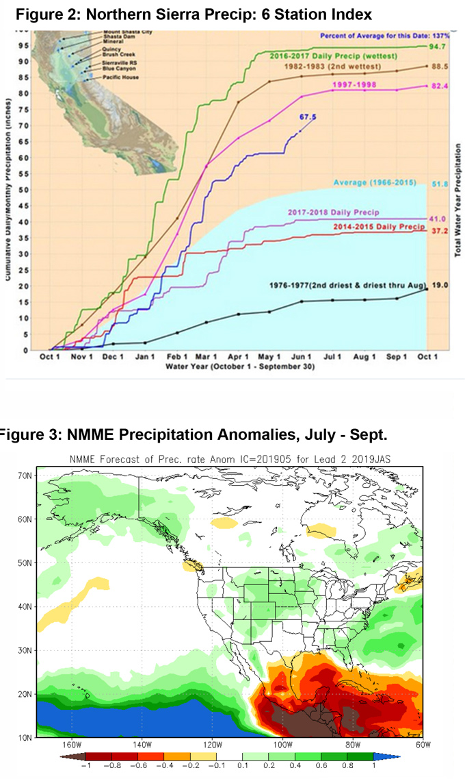
Wetting rains continued to arrive with the heaviest precipitation occurring along the Sierra Front. Mammoth Mountain recorded their snowiest May on record. Other stations in the Sierras kept pace with recording their 4th most snowpack for this time of year – 137% of normal on May 28th (Figure 2, below) Lower elevations experienced 4-6” of rainfall during the 3rd week of the month. Even Southern California saw stations record 200- 400% of normal precipitation the past 30 days (Figure 1, below).
The strangely wet and cool weather has been produced, in part, by a strong ridge over the Central Pacific which has kept the jet stream aligned in a favorable position to bring storms close to the area. The Madden Julian Oscillation may have also allowed the jet to be stronger than usual, causing the storms which did arrive to be more potent than typical late-spring storms.
Since May marks the 4th or 5th cooler and wetter than normal months in a row, the question turns to whether this favorable pattern will continue into the summer. Most long term guidance (Figure 3, below) as well as long range predictions from the Climate Prediction Center indicate much of the West will be wetter than usual. This wet scenario may mean that this year’s monsoon season will be wetter than usual for much of the CONUS, but the axis of heaviest rainfall may be well east of the district. The models have also been trending the wetter weather further away from California the past few months. This along with the possibility of sustained southwesterly flow aloft will likely result in a fewer than normal number of thunderstorm days this year. If that does come to fruition, a dry summer following a wet winter (and vice versa) would follow the pattern than has occurred several times during the past decade.
Nearly all ensemble members as well as the official outlooks from CPC forecast warmer than usual conditions during the July – September timeframe. Inland area may end being warmer than normal this summer, indeed, but unless the onshore pattern being driven by well below normal sea surface temperatures dissipates, areas near the coast may see readings closer to normal much of the summer.
Warmer than normal temperatures this summer may push energy release components quite high during the daylight hours, especially if there are a lot of clear, cloud-free days. But it may be a tradeoff as if there are fewer than normal storms, there may be fewer starts generated by lightning, especially in the Sierras.
FUELS AND DROUGHT OUTLOOK
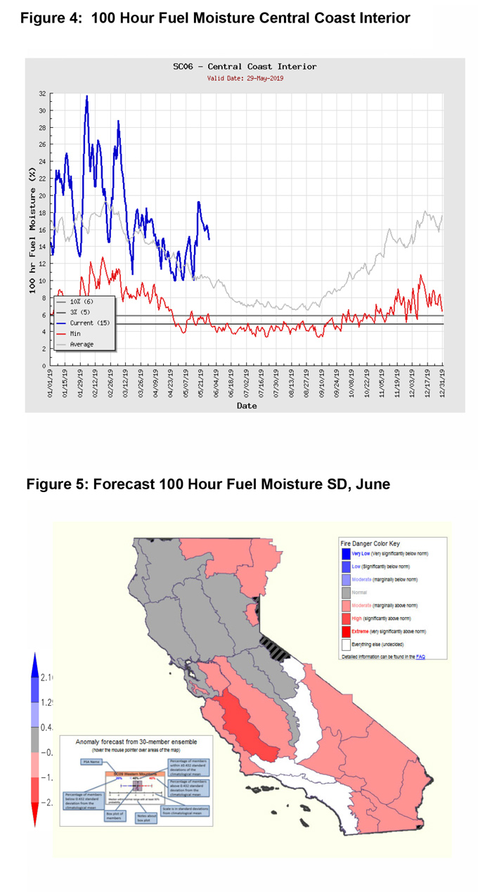
The wet weather has briefly interrupted the drying cycle over many areas. Dead fuel moisture is far above average over all areas outside the desert (figure 4, below). It will be many weeks before live fuel moisture drops toward critical levels.
Although the rain has boosted fuel moisture in the short term, enough seasonally warm weather occurred in April to allow seasonal grasses to cure over most areas outside the Sierras. There have been a few large incidents in areas with a high fuel loading of cured grasses such as the Belmont fire in San Luis Obispo County which grew to 900 acres. Once warmer weather sets in, there should still be a substantial increase in fires across similar types of vegetation. These grass fires will probably be short term events with most of them being handled by local resources.
The greater threat from large fires will occur in the summer when dead fuel moisture drops low enough in the heavier vegetation to allow for ignition. The heavy grass crop interspersed with the high amount of bug-killed timber will allow fires which begin in the grasses to transition to the ladder fuels by the middle of July. An expected lack of convection will exacerbate this situation, especially in the lower elevations of the Sierras - including the Sierra Foothills.
Given the likelihood of warmer than normal weather and a lack of monsoonal moisture, we expect large fire potential to climb to above normal levels again this year. This threat will begin in the interior foothills before spreading into some of the adjacent valleys during the latter portion of summer. Conversely, the highest elevations of the Sierras may not see much fire activity due to the lingering effects of a heavy snowpack season. Nationally, large fire potential is near to below normal over much of the Rockies and Southwest (unlike recent years) which may keep out of region demand uncommonly low.
Source: Predictive Services

