


Mariposa projected high temperature for Monday: 95 degrees and Tuesday: 96 degrees
Oakhurst projected high temperature for Monday: 94 degrees and Tuesday: 96 degrees
Yosemite Valley projected high temperature for Monday: 85 degrees and Tuesday: 87 degrees
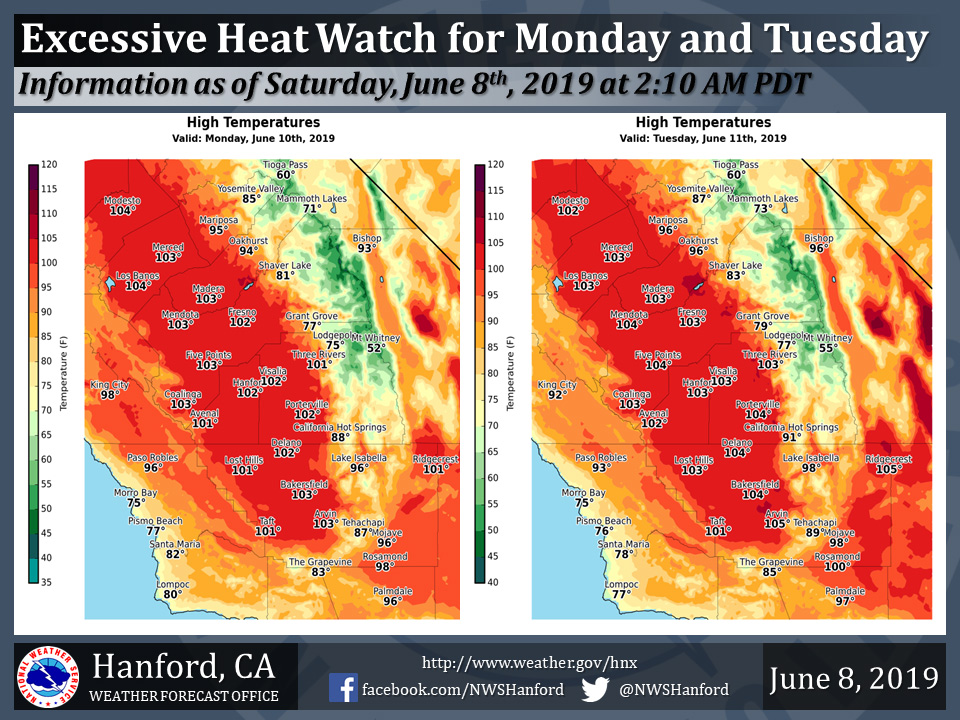
June 8, 2019 - The National Weather Service Hanford Office reports an Excessive Heat Watch is in effect for the San Joaquin Valley and west side hills from 12:00 P.M. Monday afternoon until 8:00 P.M. Tuesday evening.
High temperatures will be 100 to 105 degrees in the San Joaquin Valley and west side hills Monday and Tuesday.
An Excessive Heat Watch means that a prolonged period of hot temperatures is expected.
Heat related illnesses, such as heat exhaustion and heat stroke will be possible.
Drink plenty of fluids, stay out of the sun, and remain in an air-conditioned room.
  Area Forecast Discussion
  National Weather Service Hanford CA
  400 AM PDT Sat Jun 8 2019


  .SYNOPSIS...
  A warming trend will begin today with temperatures climbing to
  well above normal early next week. Temperatures will trend down
  late next week but will remain a little above normal. Otherwise,
  dry weather will prevail with mostly sunny skies.

  &&

  .DISCUSSION...
  An upper trough is tracking eastward over the Pacific Northwest
  this morning as a cooler air mass is in place across the region.
  Temperatures on Friday were generally around 4-8 degrees below
  normal with a few locations in the San Joaquin Valley not even
  reaching 80 degrees. Breezy conditions across the SJV yesterday
  have tapered off for the most part. But the wind continues in
  parts of the Kern County Mountains and Desert, where local gusts
  around 35 mph are occurring. These winds will gradually diminish
  through the morning as the surface pressure gradient is relaxing.

  The trough will push east over the northern Rockies today as a
  ridge of high pressure begins to build in from the south. Temps
  will warm up a few degrees today then jump around 10 degrees
  higher on Sunday with upper 90s common across the SJV. Further
  warming early next week will result in widespread triple digit
  heat across the lower elevations. Highs next Monday and Tuesday
  are forecast to be 10-15 degrees above climatological normals.
  An Excessive Heat Watch has been issued for both Monday and
  Tuesday as heat related illnesses such as heat exhaustion and
  heat stroke will be possible. People may be tempted to seek out
  the water in area rivers to cool off during the heat. But the
  heat will also bring increased snowmelt in the Sierra resulting
  in faster and deeper flows. These cold and swift waters can be
  very dangerous.

  Models bring an upper trough in from the eastern Pacific around
  midweek to begin a cool down. Highs are forecast to drop a few
  degrees each day Wednesday through Friday, ending up a little
  above normal still. Winds will increase again with the passage
  of the trough. There is a very slight chance for some afternoon
  showers along the Sierra crest later next week, otherwise dry
  weather will prevail.
Source: NWS

