


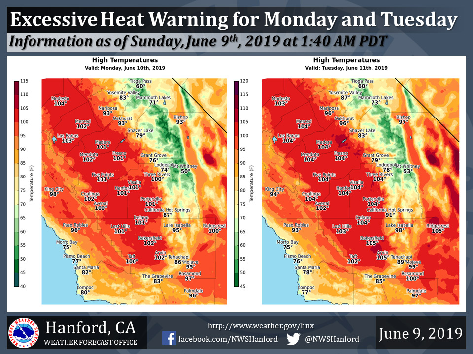
Mariposa projected high temperature for Monday: 93 degrees and Tuesday: 96 degrees
Oakhurst projected high temperature for Monday: 93 degrees and Tuesday: 96 degrees
Yosemite Valley projected high temperature for Monday: 83 degrees and Tuesday: 87 degrees
June 8, 2019 - The National Weather Service Hanford Office reports an Excessive Heat Warning is in effect for the San Joaquin Valley and west side hills from 12:00 P.M. Monday afternoon until 8:00 P.M. Tuesday evening.
High temperatures will be 100 to 105 degrees in the San Joaquin Valley and west side hills Monday and Tuesday.
An Excessive Heat Warning means that a prolonged period of dangerously hot temperatures will occur.
Heat related illnesses, such as heat exhaustion and heat stroke will be possible.
Drink plenty of fluids, stay out of the sun, and remain in an air-conditioned room.
  Area Forecast Discussion
  National Weather Service Hanford CA
  242 AM PDT Sun Jun 9 2019


  .SYNOPSIS...
  A significant warming trend will continue this weekend into early
  next week. This warming trend will peak Tuesday afternoon, then
  temperatures should slowly decrease during the remainder of next
  week. Dry weather will prevail throughout Central California for
  at least the next several days.

  &&

  .DISCUSSION...
  A ridge of high pressure over the Desert Southwest will build to
  the northwest across Central California today. As a result, high
  temperatures this afternoon will be around ten degrees warmer than
  yesterday afternoon. Maximum temperatures this afternoon will be
  five to ten degrees above normal for this time of year. The ridge
  of high pressure over the Desert Southwest will amplify over the
  Golden State tonight through Tuesday, reaching its peak strength
  Tuesday afternoon. This will coincide with the hottest day this
  week. High temperatures Tuesday afternoon will be near 105
  degrees. Maximum temperatures Tuesday afternoon in Fresno and
  Bakersfield will be two to four degrees below their daily records
  for maximum temperatures ever observed in those locations on June
  11th. An Excessive Heat Warning is in effect for the San Joaquin
  Valley and west side hills Monday afternoon through Tuesday
  evening. Plan accordingly for these dangerously hot temperatures.

  The aforementioned ridge of high pressure over California will
  translate eastward into the Great Basin Wednesday and Wednesday
  night. This will result in high temperatures Wednesday afternoon
  to not be as hot as Tuesday afternoon. Be that as it may, maximum
  temperatures Wednesday afternoon will be around ten degrees above
  their typical values for the middle of June. Zonal flow aloft will
  prevail Thursday into the upcoming weekend. A couple of subtle
  atmospheric disturbances aloft will likely pass over California
  embedded in the swift, upper-level flow. These impulses should
  destabilize the atmosphere somewhat. There may be enough of an
  increase in moisture for a few showers to develop over the higher
  terrain of the Southern Sierra Nevada next weekend. Don`t hold
  your breath though as the month of June is typically a dry month
  throughout Central California.
Source: NWS

