


Areas of Mariposa County and Madera County have a moderate risk for those who are sensitive to heat for Monday and Tuesday.
Areas of Mariposa County and Madera County have a high risk for much of the population especially those who are heat sensitive and those without effective cooling for Monday and Tuesday.
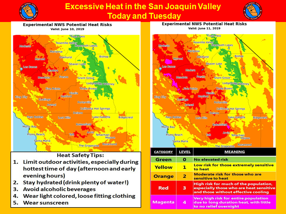
June 10, 2019 - The National Weather Service Hanford Office reports widespread triple digit heat is likely in the San Joaquin Valley this afternoon and again Tuesday afternoon.
Prolonged exposure to triple digit heat can pose a health risk to the elderly, persons with respiratory ailments and anyone who is not yet acclimated to hot weather.
If you’re going to be outdoors during the hottest time of the day (between 1:00 pm and 6:00 pm), avoid strenuous exercise, stay hydrated and wear light colored, loose fitting clothing.
Remember that going from hot air temperatures into cold water in area rivers could cause shock to the body and lead to drowning.
Use caution if entering local waterways and remember to wear a life vest.
  Area Forecast Discussion
  National Weather Service Hanford CA
  303 AM PDT Mon Jun 10 2019

  .SYNOPSIS...
  Dangerously hot temperatures are expected this afternoon and
  Tuesday afternoon in the San Joaquin Valley and west side hills.
  Triple digit high temperatures are likely Wednesday afternoon in
  the San Joaquin Valley and west side hills, before temperatures
  slowly decrease Thursday into the upcoming weekend. Dry weather
  will prevail throughout Central California for at least the next
  several days.

  &&

  .DISCUSSION...
  A ridge of high pressure over the Desert Southwest will amplify
  over Central California today and tonight. As a result, high
  temperatures this afternoon in the San Joaquin Valley and west
  side hills will be in the lower 100s. This ridge of high pressure
  will reach its peak strength Tuesday afternoon. This will coincide
  with the hottest day this week. Maximum temperatures Tuesday
  afternoon in the San Joaquin Valley and west side hills will be
  near 105 degrees. High temperatures Tuesday afternoon in Fresno
  and Bakersfield will be three to four degrees below their daily
  records for maximum temperatures ever observed in those locations
  on June 11th. As a result of these dangerously hot temperatures,
  an Extreme Heat Warning is in effect for the San Joaquin Valley
  and west side hills this afternoon through Tuesday evening.

  The aforementioned ridge of high pressure over California will
  translate eastward into the Great Basin Wednesday and Wednesday
  night. High temperatures Wednesday afternoon will not be as hot as
  Tuesday afternoon. Be that as it may, maximum temperatures
  Wednesday afternoon will be around ten degrees above normal for
  the middle of June, which would be near 100 degrees in the San
  Joaquin Valley and west side hills. A Heat Advisory may be
  required for the San Joaquin Valley and west side hills Wednesday
  afternoon and Wednesday evening.

  Zonal flow aloft will prevail Thursday through at least Friday,
  resulting in a decreasing temperature trend. A Wind Advisory may
  be required for the Kern County mountains and desert Thursday
  afternoon into Thursday night. A couple of subtle atmospheric
  disturbances aloft may pass over California next weekend. These
  impulses should destabilize the atmosphere somewhat. There may be
  enough of an increase in moisture for a few showers to develop
  over the higher terrain of the Southern Sierra Nevada next
  weekend. Don`t hold your breath though as the month of June is
  typically a dry month throughout Central California.
Source: NWS

