


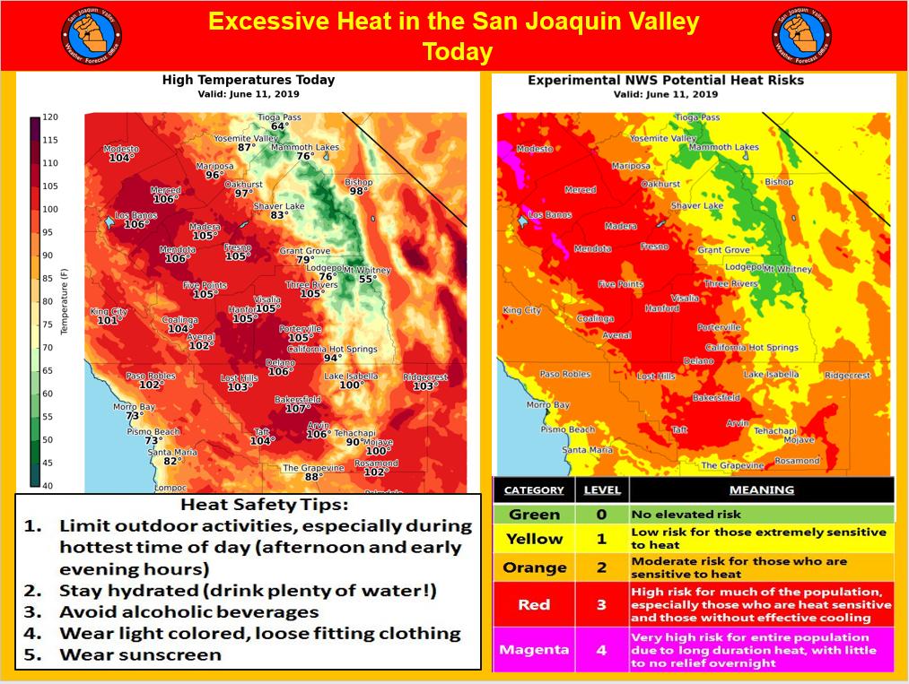
Mariposa projected high temperature for Tuesday: 96 degrees
Oakhurst projected high temperature for Tuesday: 97 degrees
Yosemite Valley projected high temperature for Tuesday: 87 degrees
June 11, 2019 - The National Weather Service Hanford Office reports widespread triple digit heat is likely in the San Joaquin Valley this afternoon.
Prolonged exposure to triple digit heat can pose a health risk to the elderly, persons with respiratory ailments and anyone who is not yet acclimated to hot weather.
If you’re going to be outdoors during the hottest time of the day (between 1 pm and 6 pm), avoid strenuous exercise, stay hydrated and wear light colored, loose fitting clothing.
Remember that going from hot air temperatures into cold water in area rivers could cause shock to the body and lead to drowning.
Use caution if entering local waterways and remember to wear a life vest.
  Area Forecast Discussion
  National Weather Service Hanford CA
  310 AM PDT Tue Jun 11 2019

  .SYNOPSIS...Triple digit heat can be expected in the
  San Joaquin Valley, lower foothills and the Kern county
  desert through Wednesday. Temperatures will trend
  slightly lower Thursday through the weekend. Isolated
  afternoon thunderstorms are possible near the Sierra
  crest beginning Thursday. Otherwise dry weather will
  prevail over the district for the next several days.

  &&

  .DISCUSSION...Residents of the central California interior
  are getting a preview of just how hot the weather can get
  and it`s not even officially Summer yet. The Summer solstice
  is still ten days away. As of this writing, temperatures are
  trending a little higher over much of the CWA compared to 24
  hours ago. That`s a good sign that today will be a little
  hotter than yesterday in most locations and could end up as
  our hottest day yet this year. High temperature records will
  be challenged today in many San Joaquin Valley locations.
  The record high of 106 degrees in Fresno and 109 degrees in
  Bakersfield for today were last established in 1979. High
  temperatures will again be over the century mark Wednesday
  in the San Joaquin Valley and most lower foothill locations
  as well as the Kern county desert. All of this exceptionally
  warm/hot weather has accelerated the rate of melting snow
  over the higher elevations of the Sierra. As this snowmelt
  process continues, it will bring a rise in water levels on
  many rivers in the foothills and higher elevations of the
  Sierra during the next 48 hours along with the possibility
  of minor flooding. The CNRFC expects the Merced River in
  Yosemite National Park to crest slightly above Flood stage
  the next couple of nights. Bottom line...rivers are not a safe
  place to be. They`re fed by melting snow which makes their
  waters dangerously cold. The other hazard of these deep,
  cold rivers are the swift currents in them. Even the most
  experienced swimmer cannot combat the strong flow of these
  rivers, so be forewarned.

  Now for the broader weather picture. If it`s cooling relief
  you`re looking for, it`s going to be minimal later this week as
  the upper level ridge of high pressure that`s currently anchored
  along the West coast finally breaks down and is replaced with a
  weak upper level trough over the Golden State on Thursday.
  Although moisture with this trough is limited, moisture from
  melting snow over the high Sierra combined with some lift from
  this trough could generate isolated afternoon thunderstorms near
  the Sierra crest each day in the 3 to 7 day period. Otherwise, the
  overall theme of the weather will be dry. High temperatures will
  be slightly cooler over the mountains and just not as hot in the
  lower elevations such as the San Joaquin Valley and the Kern
  county desert during this period. The GFS is trending temperatures
  toward climatology compared to the ECM beginning Saturday, but
  don`t let this fool you. High temperatures will still run several
  degrees above normal for the middle of June. During this current
  hot spell, please be mindful of heat safety...wear light colored,
  loose fitting clothing, stay hydrated and limit your time outdoors
  during the hottest part of the day.
Source: NWS

