


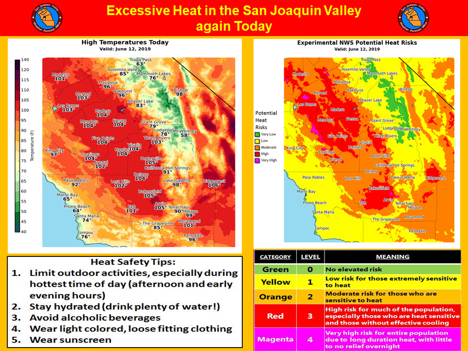
Mariposa projected high temperature for Wednesday: 96 degrees
Oakhurst projected high temperature for Wednesday: 96 degrees
Yosemite Valley projected high temperature for Wednesday: 85 degrees
June 12, 2019 - The National Weather Service Hanford Office reports a recurrence of widespread triple digit heat is likely in the San Joaquin Valley this afternoon.
Prolonged exposure to triple digit heat can pose a health risk to the elderly, persons with respiratory ailments and anyone who is not yet acclimated to hot weather.
If you’re going to be outdoors during the hottest time of the day (between 1 pm and 6 pm), avoid strenuous exercise, stay hydrated and wear light colored, loose fitting clothing.
Remember that going from hot air temperatures into cold water in area rivers could cause shock to the body and lead to drowning.
Use caution if entering local waterways and remember to wear a life vest.
  Area Forecast Discussion
  National Weather Service Hanford CA
  348 AM PDT Wed Jun 12 2019


  .SYNOPSIS...Another day of triple digit heat can be expected in
  the San Joaquin Valley, lower foothills and the Kern county
  desert. Temperatures will begin to trend slightly lower Thursday
  through the weekend and into early next week, but will remain
  between 4-8 DEG F above average. Isolated afternoon thunderstorms
  are possible near the Sierra crest beginning Thursday through next
  Wednesday.

  &&

  .DISCUSSION...
  As of 2AM PDT, Shortwave IR satellite imagery is showing
  persistent upper level cloud cover over the CWA that is associated
  with a weak, broad upper level low centered at 35N/130W. With the
  cloud cover there is no surprise that current temperatures are
  still very warm across the area with mostly low 70s to even the
  low 80s in Bakersfield, Fresno, and Merced. The upper level cloud
  cover will persist through the morning, so many locations will
  have a warm start today with low temperatures up to 10 DEG F
  above average.

  Through this evening, the weak upper level low at 35N/130W will
  move into Northern California. This will start to introduce slight
  synoptic cooling as 500mb temperatures decrease around 1-2 DEG C.
  Despite this slight cooling, the onshore flow remains weak and
  dry and with the warm start to the day, the valley and desert will
  once again reach 100-105 DEG F and 70-85 DEG F in the Sierra. As
  a result, the Heat Warning has been extended through 8 PM PDT
  for locations in the valley.

  On Thursday into Friday, near-term models show a series of weak
  upper level lows moving through the Central California interior.
  Further synoptic cooling will translate into cooler temperatures,
  which will be some 5-10 DEG F cooler compared to the last few
  days. But, overall temperatures will still remain 4-8 DEG F above
  average for this time of year. High-Resolution models are also
  picking up on some showers in the highest locations of the Sierra
  on both days which will be mostly driven by diurnal heating, and
  better orographical lift.

  On Saturday models have a weak ridge moving through the area. This
  is followed by a weak trough setting up in the area on Sunday and
  Monday. Then toward Tuesday into Wednesday, another ridge starts
  to build into the area. Through this period, overall temperatures
  will be remain around 4-8 DEG F above average with continued
  chances of afternoon convection across the high Sierra.

  One final thing to note is that river levels throughout the
  Southern San Joaquin Valley will remain high through the period
  due to the continued snowmelt.
Source: NWS

