


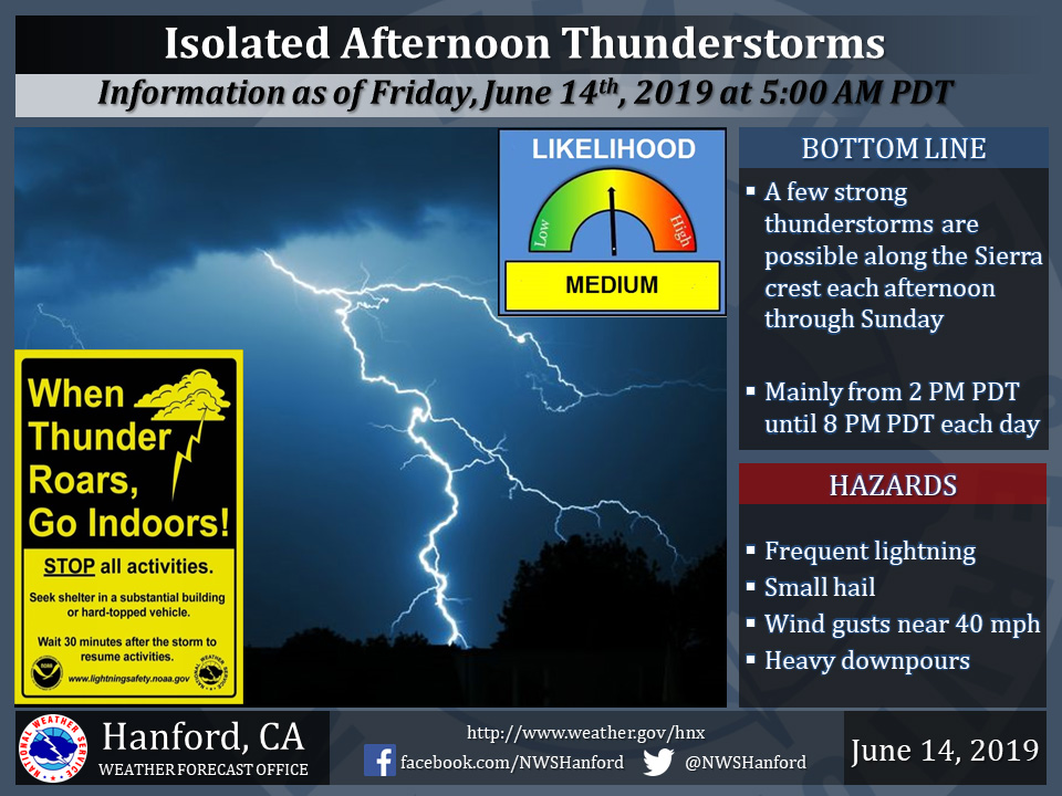
June 14, 2019 - The National Weather Service Hanford Office reports isolated thunderstorms are possible along the Sierra Nevada crest today through Sunday.
Small hail and wind gusts near 40 miles per hour are a couple of hazards associated with strong thunderstorms.
In addition to dangerous cloud to ground lightning strikes, any thunderstorm can produce intense rainfall rates, leading to localized flooding.
  Area Forecast Discussion
  National Weather Service Hanford CA
  349 AM PDT Fri Jun 14 2019

  .SYNOPSIS...Slightly cooler temperatures can be expected over
  the district through the weekend. Isolated afternoon thunderstorms
  are possible over the higher elevations of the Sierra each day
  through Monday. Otherwise dry weather will prevail through the
  period. Gusty winds will continue below the passes into tonight.

  &&

  .DISCUSSION...High temperatures yesterday were a few degrees lower
  over much of the central California interior. In the San Joaquin
  Valley, it was the first day since Sunday that thermometer
  readings stayed below the century mark. Based on current 24-hour
  trends, high temperatures today should be even a few degrees lower
  than yesterday. The comfortable change in the weather should last
  through the weekend as a couple of weak short wave troughs move
  across the Golden State.

  The first of these upper level troughs will exit into the Great
  Basin this afternoon and be followed by weak ridging aloft tonight
  into Saturday. Another weak, upper level trough will move into
  the central California interior later this weekend. Although these
  systems are limited on moisture, they`ll pick up enough moisture
  from melting snow over the highest elevations of the Sierra to
  generate isolated afternoon thunderstorms near the crest each day
  through Father`s Day. Elsewhere over the CWA, skies will remain
  mostly clear through the weekend. The passage of each of these
  upper level troughs will maintain an onshore flow across central
  California, which in turn will keep diurnal temperatures in check
  over the CWA during the next few days. Daily highs will average
  near to slightly above normal for the middle of June while nightly
  low temperatures stay relatively cool.

  The onshore flow has strengthened a bit since yesterday morning,
  and it will continue to support gusty west winds through and below
  the mountain passes today into tonight. Winds have been gusting
  to about 30 mph through Pacheco Pass and Cottonwood Pass and have
  gusted as high as 55 mph below Tehachapi Pass and Walker Pass.
  Although winds abate somewhat in these areas this morning, they`ll
  likely ramp up again this afternoon and remain gusty into this
  evening. Another wind advisory seems warranted for the Kern county
  desert right below the passes during this time period so watch
  for a new one to be issued after the current one expires at 5 am
  this morning.

  Another benefit of these upper level troughs is that they keep a
  marine layer established along the coast. The marine layer off the
  central California coast is currently about 2,000 feet deep. Its
  depth has changed little during the past 24 hours but all it has
  to do is deepen by another 500 feet or so to make it through the
  coastal mountain passes and bring further cooling into the
  northern San Joaquin Valley. If so, high temperatures could remain
  below 90 degrees in parts of Merced county the next couple of
  days.

  The onshore flow will dwindle after the weekend and become
  offshore by Monday afternoon as the second upper level trough
  exits into the Great Basin. Northeasterly winds aloft could
  carry a few Sierra thunderstorms into the foothills by early
  Monday evening and even bring some debris clouds into the eastern
  part of the San Joaquin Valley. After Monday, hot weather is
  going to make its inevitable return to the lower elevations of the
  CWA as a strong Eastern Pacific ridge of high pressure builds
  into California. Triple digit heat will return to the San Joaquin
  Valley, lower foothills and the Kern county desert Tuesday and
  persist through next Friday, which, by the way, is the first day
  of Summer.

  Despite slightly cooler weather in the short term, there`s still
  plenty of snow to melt over the high Sierra. Although that melting
  process has slowed some, rivers will continue to run deep, swift
  and cold and will remain dangerous for anyone venturing into them.
  In fact, high flows will likely continue on the rivers well into
  July or at least until all of the snow has melted over the Sierra.
Source: NWS

