


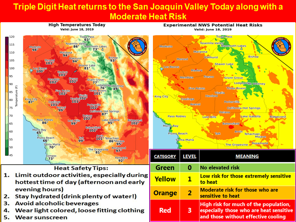
Mariposa projected high temperature for Tuesday: 94 degrees
Oakhurst projected high temperature for Tuesday: 94 degrees
Yosemite Valley projected high temperature for Tuesday: 86 degrees
June 18, 2019 - The National Weather Service Hanford Office reports a recurrence of widespread triple digit heat is likely in the San Joaquin Valley this afternoon.
Prolonged exposure to triple digit heat can pose a health risk to the elderly, persons with respiratory ailments and anyone who is not yet acclimated to hot weather.
If you’re going to be outdoors during the hottest time of the day (between 1 pm and 6 pm), avoid strenuous exercise, stay hydrated and wear light colored, loose fitting clothing.
Remember that going from hot air temperatures into cold water in area rivers could cause shock to the body and lead to drowning.
Use caution if entering local waterways and remember to wear a life vest.
  Area Forecast Discussion
  National Weather Service Hanford CA
  322 AM PDT Tue Jun 18 2019

  .SYNOPSIS...Isolated afternoon thunderstorms are possible over
  the Sierra Nevada today. Otherwise, a warming trend will occur
  the next couple of days with temperatures climbing to around 10
  degrees above normal today and Wednesday. A cooling trend will
  then occur later in the week with temperatures falling below
  normal by Friday.

  &&

  .DISCUSSION...The mid level debris clouds that were prevalent over
  our area during the evening have cleared out as high pressure
  continues to push inland into Norcal. The high is expected to
  build southward today into central CA which will result in a
  noticable warming and drying trend across our area with skies
  remaining mainly clear for the most part. Daytime temperatures
  today are expected to be 4-6 DEG F above yday which means a return
  of triple digit heat across the San Joaquin Valley. Scattered
  thunderstorms broke out yday afternoon across the Sierra Nevada
  range and a few brought heavy rainfall and gusty winds. Afternoon
  thunderstorms are once again possible over the higher elevations
  of the Southern Sierra Nevada, but coverage is expected to be
  less significant due to a drier airmass and less instability.

  The high remains in place on Wednesday with another day of triple
  digit heat anticipated for the San Joaquin Valley. Convective
  potential over the Sierra Nevada will continue to decrease as the
  airmass becomes stable.

  A strong PAC shortwave is progged to drop out of the Gulf of AK
  on Wednesday and into Oregon by Thursday. This feature is then
  progged to drop into the Great Basin Thursday night and Friday
  bringing a dry cold front through our area resulting in a period
  of increased winds during this period. Breezy to windy conditions
  will be possible across the Kern County mountains and Deserts
  Thursday afternoon and evening. This system will also bring a
  cooling trend to our area on Thursday and Friday with temperatures
  lowering to below seasonal normals by Friday as a cooler airmass
  settles in behind the front. Dry onshore flow will keep skies
  mainly clear during this period.

  Northerly flow in between the departing system over the Great
  Basin and an offshore ridge will keep our area dry with near
  normal temperatures over the weekend. Medium range models in good
  agreement with brining a large upper low into the PAC NW early
  next week which would result in a period of below normal
  temperatures across our area for much of next week. Deep moisture
  and dynamics are expected to remain to the north of our area at
  this time so precipitation is not anticipated for our area next
  week.
Source: NWS

