


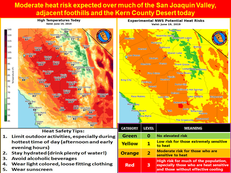
Mariposa projected high temperature for Wednesday: 93 degrees
Oakhurst projected high temperature for Wednesday: 95 degrees
Yosemite Valley projected high temperature for Wednesday: 85 degrees
June 18, 2019 - The National Weather Service Hanford Office reports a recurrence of widespread triple digit heat is likely in the San Joaquin Valley this afternoon.
Prolonged exposure to triple digit heat can pose a health risk to the elderly, persons with respiratory ailments and anyone who is not yet acclimated to hot weather.
If you’re going to be outdoors during the hottest time of the day (between 1 pm and 6 pm), avoid strenuous exercise, stay hydrated and wear light colored, loose fitting clothing.
Remember that going from hot air temperatures into cold water in area rivers could cause shock to the body and lead to drowning.
Use caution if entering local waterways and remember to wear a life vest.
  Area Forecast Discussion
  National Weather Service Hanford CA
  355 AM PDT Wed Jun 19 2019

  .SYNOPSIS...Dry weather will prevail over the district
  during  the next 7 days. Temperatures will average well
  above normal today. A noticeable cooling trend Thursday
  through Friday will be accompanied by gusty winds through
  and below the mountain passes. The weekend will bring
  lighter winds and slightly warmer afternoon temperatures.

  &&

  .DISCUSSION...A hot day is on tap for today but it should
  be the last day of triple digit heat in the San Joaquin
  Valley and the Kern county desert for at least the next
  7 days. We`ve been pretty fortunate so far this year that
  there`ve only been a handful of days at or above the century
  mark in the San Joaquin Valley and the spells of hot weather
  have been relatively short. We all know it could be much
  worse. Two years ago this week we were in the midst of a 9-day
  stretch of triple digit heat and on five of those days, high
  temperatures in the San Joaquin Valley were above 107 degrees.
  During the peak of that relentless heat wave, thermometer readings
  spiked to 110 degrees in Fresno and Bakersfield! Highs today
  will again flirt with the century mark as a ridge of high pressure
  aloft centered over the Eastern Pacific noses into central CA.
  After today, this ridge will shift far enough westward to allow
  room for an unusually deep upper level trough to drop southward
  out of western Canada into the Great Basin. The majority of the
  models track this trough as an inside slider. However, the 06z
  run of the GFS forecasts this system to track a bit farther west
  than the other models Friday. If this were to happen, it could
  bring showers into the high Sierra Friday afternoon and some mid
  level clouds as far west as the eastern San Joaquin Valley by
  Friday evening. That`s a new development from earlier GFS runs
  and for now we`re going to discount it unless the remaining
  models trend similarly.

  What we`re most confident of is the big change to refreshingly
  cooler weather later this week. Ironically it will arrive here
  Friday, which is officially the first day of Summer. The cold
  front that ushers in this cool change will be moisture starved
  and equipped with little more than some mid and high clouds as
  it sails southward through the CWA during the midday hours Friday.
  Prior to its arrival, westerly winds will increase through and
  below the passes Thursday afternoon and evening. Those breezes
  will continue through Thursday night then ramp up again in the
  wake of the cold front Friday afternoon. During this period, winds
  could kick up some dust on the west side of the San Joaquin
  Valley. In the Kern county mountains and desert, westerly winds
  might gust up to 50 mph right below the passes, especially Friday
  afternoon into Friday evening. Otherwise, high temperatures will
  trend downward significantly after today. Afternoon temperatures
  Friday will be no higher than the 80s in the San Joaquin Valley,
  lower foothills and the Kern county desert. The nights will be
  comfortably cool, too, later this week with lows in the 50s
  outside of the urban areas of the San Joaquin Valley and over
  much of the Kern county desert.

  Afternoon temperatures will bounce back to seasonable levels
  this weekend as the upper level trough moves out of the Great
  Basin and the Eastern Pacific ridge begins to build back into
  the Golden State. Sunday will definitely be the warmer day of the
  weekend after a residual cool start to the day. A day to day
  cooling trend may become re-established over the CWA early next
  week as yet another upper level trough settles southward out of
  western Canada. By next Wednesday, a robust onshore flow could
  bring ocean cooled air inland and keep high temperatures below 90
  degrees over much of the San Joaquin Valley.
Source: NWS

