


Temperatures slightly above normal, mainly across inland areas.
Below normal number of summer thunderstorms outside the deserts.
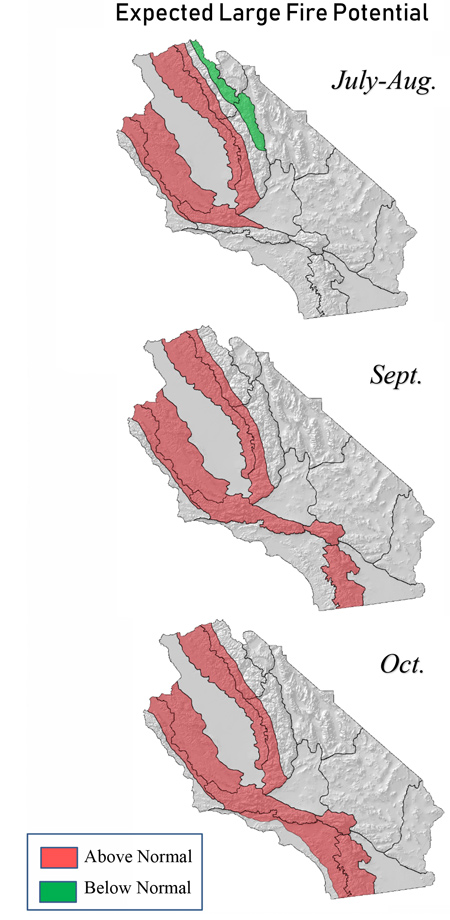
Large fire potential trending above normal this summer in the foothills and inland valleys due to tree mortality.
Above normal large fire potential spreading into Southern California
Weather Discussion
July 2, 2019 - The past month was cooler and wetter than normal for the southern section of the district as onshore flow continued to dominate the weather pattern. Several unseasonably
 deep troughs produced some spotty showers and wet thunderstorms, bringing measurable precipitation to the Sierras as well as other mountainous areas. Southern California also experienced some light rain which is quite unusual for June. Due to the pervasive stratus coverage, Southern California temperatures responded accordingly with monthly departure from average readings anywhere from 4-6 degrees below average.
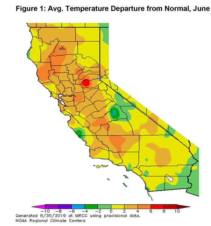
However, areas of Central and Northern California west of the Sierras experienced wildly different weather conditions during the past 30 days. Northerly winds kept marine layer coverage at bay along the central coast while some downsloping effects allowed the San Joaquin Valley to see frequent 100- degree temperatures. Monthly temperature averages for June were substantially above normal from areas extending north of Santa Barbara and Kern County (Figure 1, below).
Cooler than average sea surface temperatures may have been partially responsible for frequent troughs off the coast as well as stronger than normal jet energy across the Pacific. There are signs this trough-heavy pattern may change to more of a blocking pattern if the Pacific North American Pattern (PNA) index goes to a positive value as forecast by the models used by the Climate Prediction Center. This along with a weakening jet may keep a strong ridge aligned over the Eastern Pacific.
The result of ridging off the coast would be a change to a warmer and drier weather pattern for the Southern CA with far less marine layer coverage. Central CA may see the heat of late June continue into July.
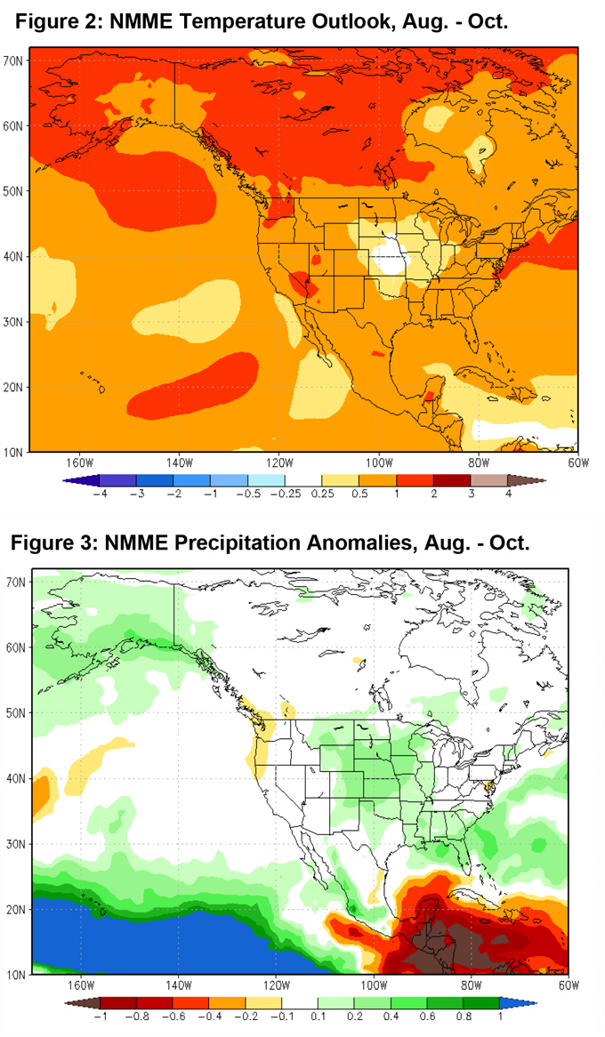
In fact, much of the continental U.S. is forecast to see above normal temperatures this summer. Between the expected above normal temperatures of the Eastern and Western U.S., a patch of near normal temperatures is forecast this summer into fall over the Midwest (Fig. 2, right). This might be where the main axis of monsoonal moisture may lie much of the summer…far east of the Geographic Area. Given long range models consistency with regard to precipitation distribution over the CONUS, we are expecting below normal summertime monsoon-generated thunderstorm activity this year (Fig. 3, below).
A lack of moisture over northern Mexico so far this summer may also lead to a summer monsoon which is delayed. Areas of the far eastern desert may see closer to normal precipitation amounts this year, but most forested areas - including the Sierras - should have fewer than normal storms this summer.
FUELS AND DROUGHT OUTLOOK
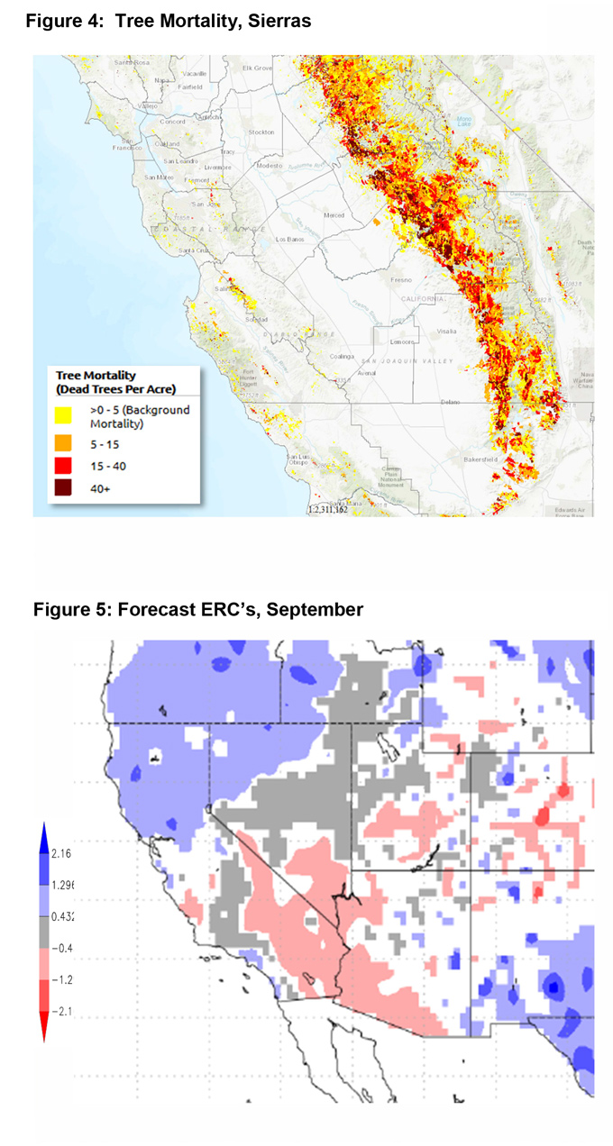
Much of this calendar year, conditions have remained rather cool and wet which has led to a slow start to fire activity both locally and nationally. But from a fuels perspective, conditions are still favorable for a busy summer fire season once again. Tree mortality and its subsequent influence on fuels in the Sierra Foothills will continue to be the principal area susceptible to large fires (Fig. 4, left). The tall and dense grass crop generated by the wet winter may lead to new starts propagating rapidly from the ground fuels into the taller ladder fuels. These large diameter, heavy fuels are co-mingled with a high amount of dead fuels, especially from Tuolumne County southward. Should a new fire develop in these areas during hot or windy periods, containment may prove challenging.
An expected lack of summer thunderstorms in the Sierras may lessen the chance of a lightning-started fire, but fires that are human caused (the majority of fires across the Geographic Area) may find trees, shrubs and grass with below normal fuel moisture in both live and dead fuels. Sunnier and hotter weather may result in fewer starts, but the fires that do develop have a greater chance of becoming large in a low-monsoon scenario.
The rest of the Geographic Area should see large fire potential increase to above normal from north to south as the summer progresses into fall. Live fuel moisture in chaparral and other native shrubs of Southern California may remain near to slightly above normal through the summer, but by fall, these fuels should be dry enough to support large fire growth. Like fuels further north, there are widespread dead fuels present due to the long-term effects caused by the 5-year drought. These fuels will likely be the driver of large fire activity in the summer and early fall months. By the middle of fall, large fire activity may spike across Southern California once offshore wind events become increasingly likely.
Large fires will likely be driven by fuels due to the poor vegetative health of many fuel beds. Once the dead fuels assume a below normal level of fuel moisture (possibly as soon as late July), there will be an above normal chance of seeing large fires. This increased large fire threat will likely not be alleviated until meaningful rainfall returns in November or December.
Source: Predictive Services

