


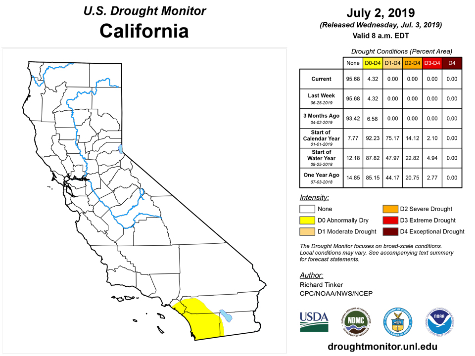
California and National Drought Summary for July 2, 2019
Summary
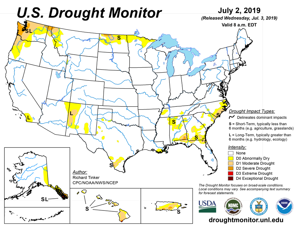
July 3, 2019 - It was a mixed picture for the dry areas across the country. Widespread rainfall totals exceeding 2 inches fell from northeast Montana to north-central North Dakota, with a swath of 4 to 6 inches soaking part of northwest North Dakota. Farther east, generally under an inch fell on northeastern North Dakota and northern Minnesota near the Canadian border, with amounts increasing to the south. Between 0.5 and 2.0 inches of rain fell on the climatologically-wetter areas of the Pacific Northwest on the west side of the Cascades and along the immediate coast, and 0.5 to 1.0 inch fell on northwestern Montana and part of adjacent Idaho. Other parts of the Northwest recorded less than 0.5 inch, with only a few tenths of an inch falling on most of interior Washington and Oregon. Very little, if any, precipitation fell farther to the south, from central Oregon and Idaho southward through the Far West, and roughly the western half of the Four Corners region. Rainfall was highly variable through south Texas and the Southeast (not uncommon during summer). Several small areas from south Georgia, north Florida, and Alabama westward received over 2 inches of rain, with isolated amounts reaching nearly 6 inches in south Texas. Rainfall was considerably sparser from central and north Georgia through the Carolinas, where most sites recorded only a few tenths of an inch. Outside the contiguous states, light to moderate rains fell on north-central and central Puerto Rico while little or none was observed along the southern tier of the Commonwealth. Historically heavy out-of-season rains soaked parts of the leeward areas across Hawaii, with over 4 inches soaking Honolulu within 24 hours – more than any prior full month of June on record brought.
Northeast
Some short-term precipitation shortfalls have popped up across interior southern New England and a few other isolated areas, but D0 introduction was not warranted at this time, and the region remains free of any dryness on the Drought Monitor.
Southeast
The rainfall pattern was highly variable across the region. Amounts of 0.5 to 2.0 inches (and locally greater) were common across south Georgia, north Florida, and the west half of Alabama, but only scattered to isolated areas across southeast Louisiana, north and central Georgia, and most of the Carolinas received as much. The broken rainfall pattern resulted in numerous small tweaks across the region, but larger changes included the removal of D0 through significant swaths of southern South Carolina and central Georgia (based on a re-assessment of effects from last week’s heavy rain), and some westward and southward expansion of the moderate drought near the coast of the central Carolinas.
South
Light to isolated moderate rainfall kept D0 essentially unchanged in western Tennessee. Farther south, an area of 2 or more inches of rain eliminated the D0 near south-central Louisiana, but lighter rains to the east kept abnormal dryness in other parts of southeast Louisiana. Across central Texas, rainfall was sparse, and several small areas of D0 there. In south Texas, where more marked dryness existed, a small swath of heavy rain (up to 6 inches) eliminated severe drought across interior areas, and ended the moderate drought farther north toward Laredo. In contrast, lesser rains allowed severe drought to develop in a small area of far southwest Texas, and kept dry conditions generally unchanged in the rest of south Texas.
Midwest
Another week of heavy rainfall affected areas from Wisconsin and north Iowa northward through most of Minnesota, but precipitation was again sparse along the northern tier of that state, allowing moisture deficits to increase and prompting the extension of D0 eastward along the Canadian border. A broken pattern of moderate to heavy rain fell on a swath across Illinois and adjacent areas to the east and west while much of Iowa, Missouri, central and east Indiana, and most of Ohio and Kentucky were drier. No abnormal dryness was identified anywhere outside the north tier of Minnesota.
Another wet week was observed across northwest North Dakota, with amounts of 4 to locally over 6 inches soaking a swath just south of the Canadian border. This resulted in the removal of D0 from much of the area. Conditions were considerably drier farther to the east, keeping D0 to D2 intact over central and eastern parts of North Dakota, and allowing for some southward and eastward D0 expansion in northeastern North Dakota toward Minnesota. Copious rainfall was measured in central parts of the region, but only a few patches across Colorado and Kansas received over 0.5 inch. No dryness or drought was noted south of central North Dakota.
West
Another week of moderate to heavy rain in northeast Montana eliminated any residual abnormal dryness there. Conditions also improved in southwestern Montana, but dryness and drought persisted or intensified from the Northwest coast through west-central Montana. Recent dryness prompted D0 expansion through west-central Montana and adjacent Idaho, east-central Washington, and part of southwest Oregon while moderate drought was extended slightly farther south in coastal western Oregon. Moderate to severe drought, with subnormal weekly precipitation, persisted from north Idaho westward through northern and western Washington and northwestern Oregon. The drought is becoming fairly entrenched in parts of the Pacific Northwest, but no increase in D1 or D2 coverage seemed appropriate at this time.
Alaska, Hawaii, and Puerto Rico
The southern Alaska Panhandle had its driest June 2018 through May 2019 period on record, which supports the ongoing extreme drought (D3). Long-term precipitation deficits also persist across the rest of the southern Panhandle, leaving D0 to D2 conditions essentially unchanged. The abnormal dryness continued farther north through east-central Alaska, and while some slow drying was noted farther west, no D0 expansion was introduced yet. Still, Anchorage, AK just endured their warmest and driest June on record, and the dryness has begun influencing both streamflows and wildfires in central Alaska, so this region will be closely monitored. Meanwhile, a slow expansion of dryness and drought continued across Puerto Rico. Some extreme drought was introduced along the South Slopes where brush fires, declining well water levels, and some agricultural losses have been observed. Across the Hawaiian Islands, historically heavy out-of-season rainfall occurred on parts of the dry areas in leeward areas, especially across Niihau, Kauai, Oahu, and Molokai, where all D0 to D2 areas were improved one category.
Pacific Islands
The weather pattern during this USDM week (6/26/19-7/02/19) consisted of surface troughs, tropical disturbances, upper-level lows and troughs, and converging trade winds (mostly in the south and west), and a dry trade-wind pattern (mostly in the north). A tropical disturbance (Invest 95W) moved across western Micronesia early in the week. When 95W crossed into the Philippine Sea, it intensified into Tropical Storm 04W with a surface trough extending eastward into central Micronesia. The upper-level lows and troughs kept mostly over western Micronesia. They combined with surface troughs over Palau and Yap State to enhance precipitation, but were opposed by the dry trade-wind flow over the Marianas which inhibited precipitation. Surface troughs and trade-wind convergence brought precipitation to parts of eastern Micronesia, but mostly to the southern sections as the dry trade-wind pattern dominated in the northern areas. South of the equator, a surface trough kept mostly to the north of the Samoan Islands and a mid-level trough moved over the west, but a high pressure ridge from the south mostly dominated the weather over American Samoa.
Satellite-based estimates of 7-day precipitation (QPE) showed a large area of 2 to 4 inches of precipitation across Yap State and Palau, with patches of 1-3 inches over eastern parts of the Federated States of Micronesia (FSM) and southern parts of the Marshall Islands (RMI), and little to no rainfall outside these areas. A large area of 2-4 inches of rain was indicated across the western Samoan Islands and to the north, but little rain to the south and east, with a sharp gradient between these areas occurring across American Samoa.
Dry conditions persisted across much of the Marianas this week, with two of three stations (Guam and Saipan) analyzed reporting precipitation totals less than half their weekly minimum of 1 inch to meet most water needs. The station with the least precipitation was Guam which had only 0.37 inch during the week ending July 2. Meanwhile Rota had its first wet week since the week ending May 21 with a rainfall total of 1.23 inches. However, extreme drought (D3-S) remains in Rota.since it has been extremely dry the last few months with monthly precipitation totals less than 2 inches since March 2019. Guam and Saipan were also in extreme drought this drought week.
Wet conditions returned this week to Palau, with precipitation total at 4.92 inches. This is more than double the weekly minimum (2 inches) requirement to meet most water needs. Since the month of June was extremely wet and this week the precipitation totals surpassed the weekly threshold, Palau’s drought status was changed to abnormally dry (D0-S).
Dry conditions were present across much of FSM, with about half of the stations reporting less than 1 inch of precipitation during this drought week. The FSM weekly minimum to meet most water needs is 2 inches. The station with the least precipitation total was Pohnpei, which only had 0.18 inch of rain for the week. Although Pohnpei had a very dry week, its drought status of no drought (D-nothing) remained unchanged since the last few months have been extremely wet, especially the month of June (22.95 inches) which had nearly triple the monthly minimum of 8 inches. Similarly, Kosrae, Lukunoch, Nukuoro, Woleai, and Pingelap had dry conditions this week. However, since the June precipitation totals surpassed their 8 inch monthly threshold to meet most water needs, no drought (D-Nothing) persisted in these locations. The month of June marked the first month since January 2019 in which the monthly threshold of 8 inches was met in Fananu. However, the precipitation total for this week was 0.28 inch (with 3 days of missing data). Moderate drought was unchanged for Fananu.
There were three stations (Yap, Chuuk, and Kapingamarangi) that had wet conditions this week, surpassing their weekly minimum of 2 inches. Kapingamarangi had the most precipitation with a total of 4.89 inches (with 1 day of missing data) for the week ending July 2. Kapingamarangi has been extremely wet the last few months and the month of June had a total of 23.69 inches, which is nearly triple the monthly minimum of 8 inches. Kapingamarangi continues to be drought free (D-Nothing) this week. Yap had its second consecutive week with wet conditions. After four months of dry conditions, the month of June was a wet month for Yap with a total of 10.83 inches⏤which is 2.83 inches more than the threshold of 8 inches to meet most water needs. Yap’s drought status was changed from moderate drought (D1-S) to abnormally dry (D0-S). Chuuk’s drought status was changed to drought free (D-Nothing) considering that it was a really wet month. June had a total of precipitation of 14.64‒‒nearly twice as much as the monthly minimum of 8 inches.
Unfortunately no analysis was made to Ulithi since no data was available at the time of analysis.
The Marshalls Islands also experienced dry conditions this week. Most stations analyzed had less than 1 inch of precipitation for the week. Wotje had the least precipitation, receiving no rain. Exceptional drought remained in Wotje as well as in Utirik. Jaluit was the only station that precipitation totals near the 2 inch threshold at 1.97 inches of rain this week. Since dry conditions have persisted in Jaluit for several months, moderate drought (D1-S) remains this week. Kwajalein was also in moderate drought this week, receiving only 0.33 inch of rain. Meanwhile, Ailinglapalap and Mili were drought free even though they had a dry week. The last two months (May and June) for these locations met or surpassed their monthly precipitation threshold of 8 inches. Majuro also had a dry week (0.59 inch). Even though reservoir levels have been above the critical 80% level (86% as of June 28), water restrictions are still in place. For this reason, abnormally dry conditions remain in Majuro.
Pago Pago had a dry week, with precipitation totals at 0.85 inch. This is 1.15 inches less than the weekly minimum of 2 inches to meet most water needs and marks the second consecutive week with dry conditions. Overall, the month of June was dry with precipitation totals less than the 8 inch threshold at 6.21 inches. However, since the previous months were extremely wet, Pago Pago remains drought free for now.
Virgin Islands
Rainfall totals at Cyril E King Airport during this drought week was 0.14 inch. The month of June was extremely dry, receiving only 0.58 inches of rain, which is 1.95 inches less than normal June precipitation or 23% of normal precipitation. In addition, dry conditions have plagued the island since the start of the year. The precipitation total for King Airport for January-June 2019 was 8.94 inches or 66% of normal. The SPI for the last six months was -1.1 and -0.9 for the 9-month period, which is consistent with moderate drought conditions. For this week moderate drought (D1-SL) remains unchanged this week for St. Thomas.
Similar to St. Thomas, St. Croix was dry as well this week. Total precipitation for the drought week ending July 2 at Henry Rohlsen Airport was only 0.34 inch. The month of June only had a total of 0.50 inch of rain, which is 1.81 inches less than the monthly average of 2.31 or 22% of normal. For the year-to-date, the Rohlsen Airport had only 8.08 inches of rain, which is 58% of normal precipitation. The SPI for the last six months at Rohlsen Airport was -1.1 and -1.3 for the 9-month period, which is consistent with moderate to severe drought conditions. This week moderate drought (D1-SL) remains unchanged for St. Croix; however, if dry conditions persist, a change to severe drought might be considered next week.
According to data provided by a volunteer observer, St. John’s weekly precipitation total for this drought week was 0.51 inches. However, the month of June had a total of 4.55 inches of rain, which is 159.1% of normal precipitation for the month. This was the wettest June since 2010 and the wettest month since November 2018. The last few months have been extremely dry, with precipitation totals below 1 inch during February, March, and April, which is less than 50% of normal precipitation for each respective month. May had a bit more precipitation at 3.63 inches, but it was still below normal. The year-to-date precipitation total was 11.88 inches or 69.5% of normal. For this reason, St. John’s drought classification was set to abnormally dry (D0-L).
Looking Ahead
During the next 5 days (July 3 - 7, 2019), much of Florida, southeastern Georgia, and the eastern Carolinas are expecting between 1 and 2 inches of rain, and over an inch is also anticipated in central and eastern sections of northern Minnesota. But other areas of dryness and drought across the contiguous 48 states should receive less, likely providing little if any benefit. Areas of North Dakota and western Minnesota along the Canadian border anticipate a few tenths of an inch, as do most areas from Texas eastward through central and north Georgia. Little precipitation, if any, is forecast for the dry areas from west Montana and the Pacific Northwest southward through the Far West, Great Basin, and Four Corners region. Unusually mild weather from the north Intermountain West through the northern Plains should at least slow any tendency toward increasing dryness there, but hotter-than-normal conditions in the Southeast may temper benefits that might result from moderate rainfall.
The CPC 6-10 day outlook (July 8-12, 2019) favors wetter-than-normal weather in the Southeast, the northern Plains, north and west Texas, the northern Intermountain West, and the Alaska Panhandle. Meanwhile, enhanced chances for abnormally dry weather exist in south Texas and in parts of western Washington and Oregon. The mild temperatures expected during the first week of July should continue in east Montana and the western Dakotas, but abnormally warm weather is favored in the West Coast states, the Intermountain West, the southern Plains, and the southeastern quarter of the country.
Author(s):
Richard Tinker, NOAA/NWS/NCEP/CPC
Ahira Sanchez-Lugo, NOAA/NCEI
Dryness Categories
D0 Abnormally Dry—used for areas showing dryness but not yet in drought, or for areas recovering from drought.
Drought Intensity Categories
D1 Moderate Drought
D2 Severe Drought
D3 Extreme Drought
D4 Exceptional Drought
Drought or Dryness Types
S Short-Term, typically less than 6 months (e.g. agricultural, grasslands)
L Long-Term, typically greater than 6 months (e.g. hydrologic, ecologic)
Source: National Drought Mitigation Center

