


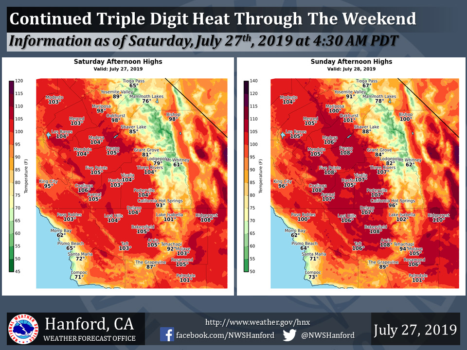
Mariposa projected high temperature for Saturday: 98 degrees, Sunday: 100 degrees
Oakhurst projected high temperature for Saturday: 98 degrees, Sunday: 101 degrees
Yosemite Valley projected high temperature for Saturday: 89 degrees, Sunday: 91 degrees
July 27, 2019 - The National Weather Service Hanford Office reports high temperatures this weekend will rise well into the triple digits, or around 105 to 110 degrees, at many locations, especially in the San Joaquin Valley and the Kern County desert areas.
Plan to take action to reduce time outdoors, drink plenty of water, and remain in air-conditioned buildings.
Heat-sensitive groups, such as the elderly, young children, and those with chronic ailments may need assistance to avoid heat-related illness.
As always, never, ever leave a child or pet in an enclosed automobile.
  Area Forecast Discussion
  National Weather Service Hanford CA
  220 AM PDT Sat Jul 27 2019


  .SYNOPSIS...
  A large area of high pressure will maintain widespread triple
  digit heat across the San Joaquin Valley, West Side Hills and Kern
  County Deserts through Monday. The peak of this heat should occur
  this weekend. Temperatures trend back to normal beginning Tuesday.

  &&

  .DISCUSSION...
  High pressure remains in firm control over the region with hot
  temperatures continuing through the weekend. The ridge has shifted
  farther west, with the flow aloft west-southwesterly. This has
  pushed the monsoonal moisture eastward. Thus, do not expect to see
  any more thunderstorms, but could see a few cumulus buildups over
  the higher elevations of the Sierra Nevada today. Dry weather is
  expected the rest of the 7 day period.

  Temperatures will remain in the triple digits across the San
  Joaquin Valley, the West Side Hills, and the Kern Desert areas
  through Monday. A heat advisory remains in effect for this
  afternoon and evening. For now will continue with the excessive
  heat watch for Sunday as models have been fluctuating between an
  advisory and a warning. Will let the day shift assess.

  On Monday, 500mb heights begin to decrease slightly as the ridge
  axis gradually shifts eastward again and a trough of low pressure
  forms along the west coast. This will allow temperatures to start
  edging back down next week. The widespread triple digits will
  remain Monday, then temperatures will be near normal Tuesday
  through next Friday.
Source: NWS

