


Temperatures slightly above normal, mainly across inland areas.
Below normal number of thunderstorms associated with the monsoon.
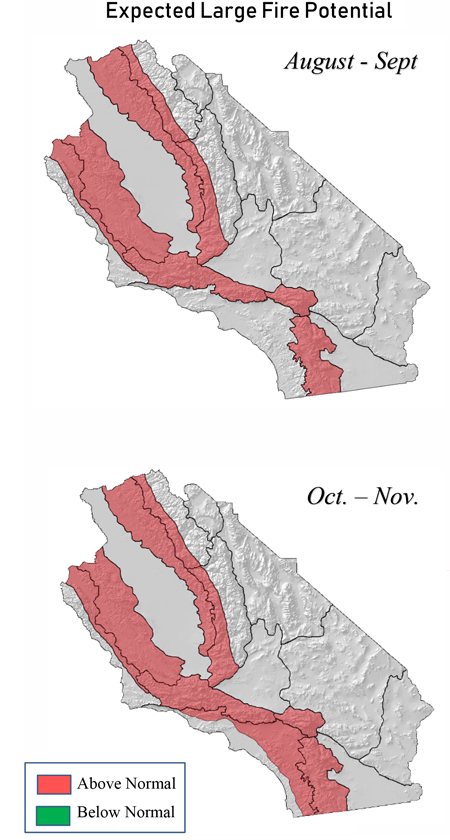
Above normal large fire potential – especially in the foothills and inland valleys - due to tree mortality.
Chance of a delayed start to the winter “rainy season”
Weather Discussion
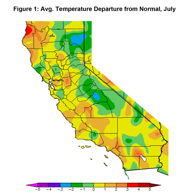
August 2, 2019 - Average temperatures this past July were well above normal across much of the area (Figure 1, below). This stands in sharp contrast with the cool conditions which
 persisted much of the winter and spring. Strong ridges of high pressure brought extreme heatwaves to large swaths of the country last month. While California was spared the worst of the heat, a high pressure ridge brought notable heatwaves during the third week of the month.
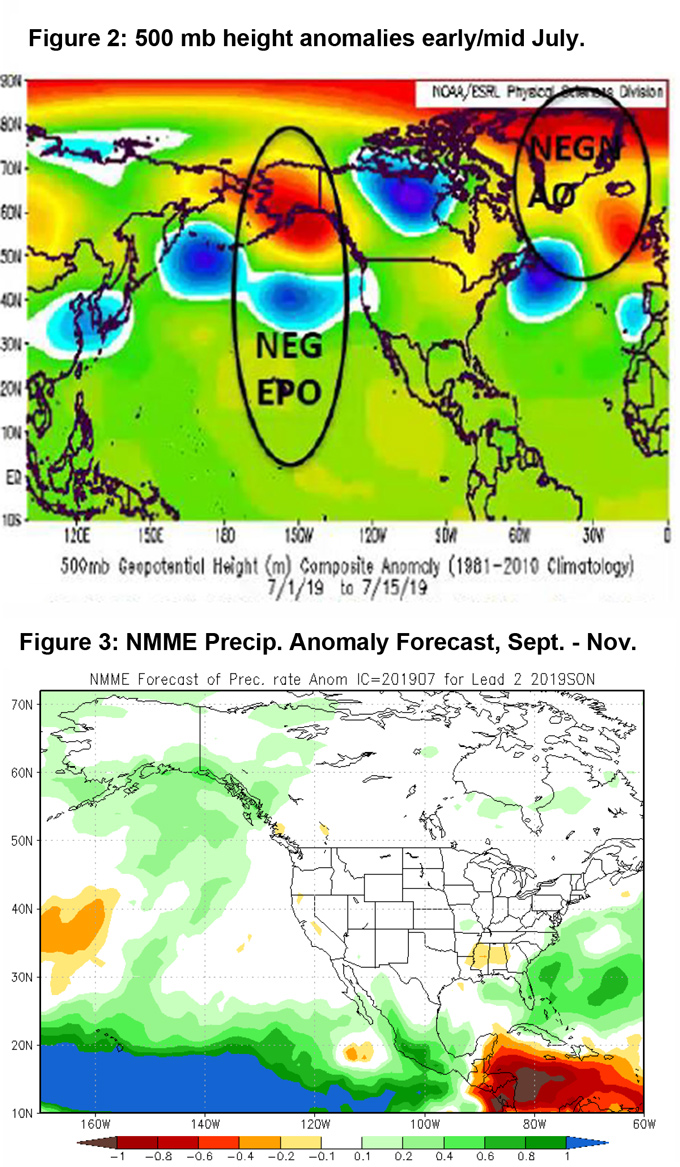
More notable was the near complete absence of monsoon related thunderstorms. Ordinarily, July is one of the stormiest months of the year – particularly for the Sierras and deserts both of which receive sizable portions of their annual precipitation from summer convection. The lack of storms was largely the result of sustained southwesterly flow aloft which was generated by persistent troughs over the Pacific Northwest. In addition, the moisture supply over the normal source region (northern Mexico) was often lacking. Therefore, even when upper level patterns were favorable for the import of subtropical moisture, there was little available moisture to transport northward into California.
During the past month, sea surface temperatures (SSTs) seemed to evolve to one which may be familiar to many followers of long range weather forecasting. Record high temperatures over Alaska (including all-time record high readings in Anchorage) may have helped spur on the rapid warming of SSTs in the Gulf of Alaska. Strong ridging over this area along with frequent troughing further south near the Pacific Northwest allowed long wave weather patterns to resemble those most often seen during negative Eastern Pacific Oscillation (-EPO) episodes.
When the EPO is in a negative phase, the central part of the country is often cooler and wetter than average while western sections of Canada into Alaska are much warmer than normal. The average height anomaly chart of early July (Figure 2, below) lines up with SST anomalies over the Pacific extremely well. The rapid evolution of this warm water in roughly the same position as during the extreme drought years of 2013-2018 is worrisome. Should this warm body of water remain in place in coming months, it may lead to a return of warmer and drier weather for the coming rainy season. But as Dr. Daniel Swain points out in his weather blog, it is far from certain whether this “blob” is transitory or whether portends a grim rainy season.
For what it’s worth, the NMME precipitation outlook for September – November shows drier than normal conditions continuing into the fall. Ordinarily the monsoon is over with by the middle of September, so this lack of forecast precipitation is representing perhaps a late start to the winter time storm pattern. Most other evidence is indicating the same thing at the time of this writing and there is increasing confidence of a late start to the “winter rainy season”
If this negative EPO pattern were to continue into the fall, there is a chance that it may lead to an increasing likelihood of offshore wind events. It is too early to predict whether long wave patterns would be amplified enough to generate cold air advection far enough west into the Great Basin to drive these events, but should conditions remain the same as they are now, a higher number of offshore wind events than normal may be possible.
FUELS AND DROUGHT OUTLOOK
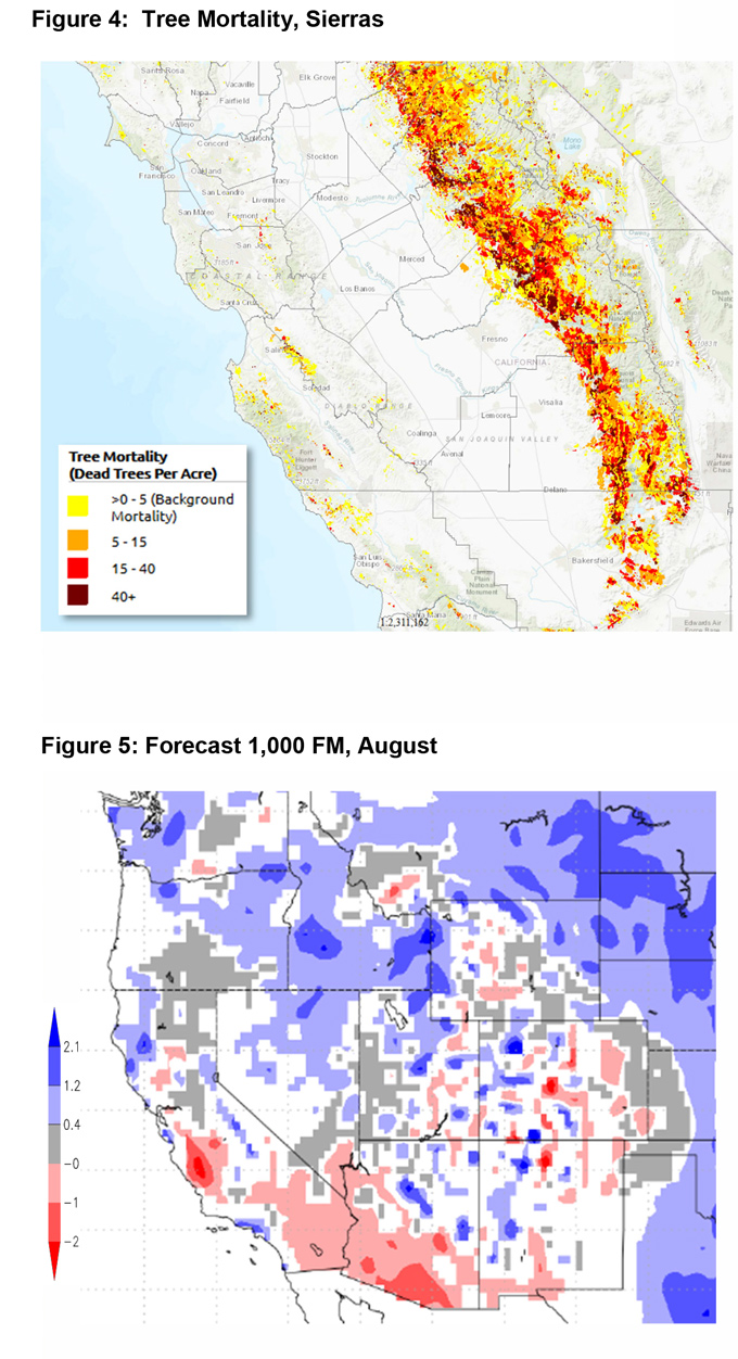
After weeks of very limited fire activity, initial attack sudden surged at the end of July. This is likely in response to dead fuel moisture crossing the threshold to below average moisture conditions. Strong drying conditions were experienced in July, not only due to warmer than normal conditions, but also due to the lack of afternoon convection. Long daylight hours with little cloud cover caused dead fuel moisture to trend sharply downward. The expansive dead fuel beds found along the central coast and the Sierras were the first areas to see large fire activity this season, which is not surprising in a year without thunderstorms to spark ignitions elsewhere.
The poor condition of many plant species will continue to be the driver of fire activity for a few more weeks until live fuel moisture readings drop to near or below normal readings. This should happen by the start of September, at which point most of the Geographic Area away from marine layer influences should be experiencing above normal large fire potential. Expect these fires to grow rapidly, even during weather conditions which are not normally associated with large fire growth. The Holy Fire in the Cleveland National Forest is an example of an incident which grew rapidly despite moderate levels of humidity, wind and temperature. Heavy fuel loading of dead fuels will continue to lead to well above normal large fire potential into the fall across the Geographic Area and the expectation of warmer and drier than normal conditions may only exacerbate this issue.
A slow start to the summer fire season may have led to the assumption that this would be a quiet year with few large fires to contend with. A slow fire season may have resulted from rainy winters in the distant past, but the damage produced by the drought and the bark beetle will continue to exact a toll for years to come.
Source: Predictive Services

