


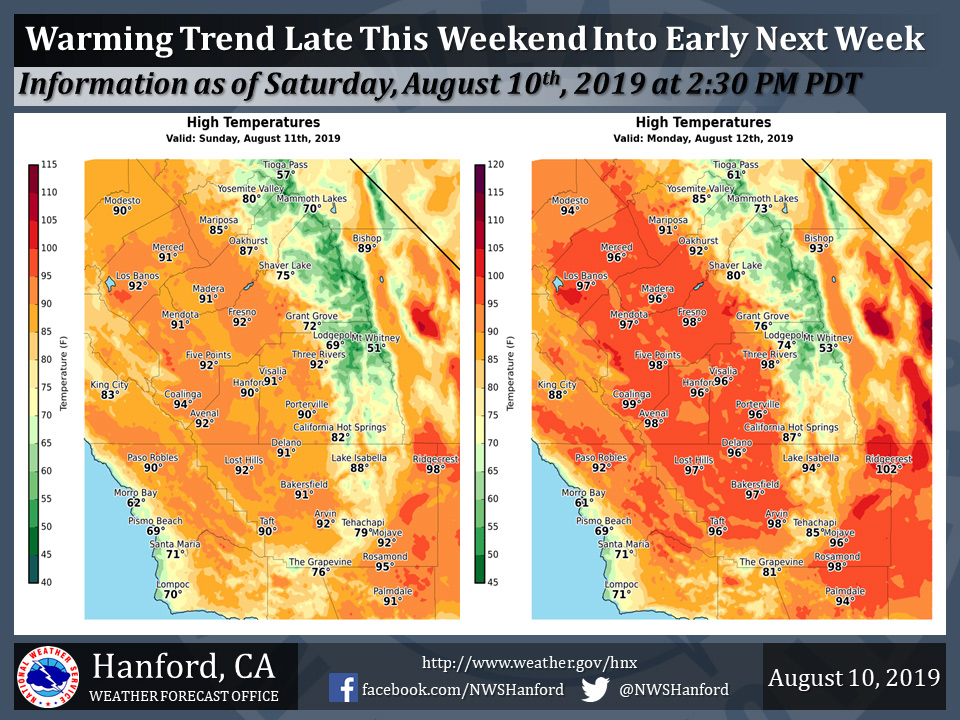
Mariposa projected high temperature for Sunday: 85 degrees and Monday: 91 degrees
Oakhurst projected high temperature for Sunday: 87 degrees and Monday: 92 degrees
Yosemite Valley projected high temperature for Sunday: 80 degrees and Monday: 85 degrees
August 11, 2019 - The National Weather Service Hanford Office reports a warming trend will begin late this weekend and persist through at least early next week.
High temperatures Monday afternoon in Central California will be near normal for this time of year.
Widespread triple digit heat is expected throughout the San Joaquin Valley Tuesday and Wednesday.
  Area Forecast Discussion
  National Weather Service Hanford CA
  103 AM PDT Sun Aug 11 2019

  .SYNOPSIS...
  Temperatures will remain below normal for this time of year today.
  Significant warming will take place Monday. Widespread triple
  digit heat is expected in the San Joaquin Valley Tuesday and
  Wednesday, prior to a cool down late next week into next weekend.
  Dry weather will persist.

  &&

  .DISCUSSION...
  Omega blocking pattern locked in place across the lower 48 at the
  moment. This will break down today as the upper trough over the
  PACNW will open up and move east which will allow the ridge to
  settle south. We will see two more days of below normal
  temperatures before a gradual warm up will take place across the
  CENCAL interior.

  Guidance is advertising temperatures to reach near normal by
  tuesday and slightly above on Wednesday. We are expecting another
  trough of low pressure to move into the PACNW by Thursday night.
  Synoptic scale cooling is expected by Friday and continue into
  Saturday with a decent marine push on Thursday for the SJV. Best
  dynamics will remain well to the north and we are not anticipating
  any precipitation across the Sierra with this trough. So another
  decent late summer cooldown across the region is in store after a
  brief warmup.
Source: NWS

