


Mariposa projected high temperature for Thursday: 99 degrees
Oakhurst projected high temperature for Thursday: 99 degrees
Yosemite Valley projected high temperature for Thursday: 91 degrees
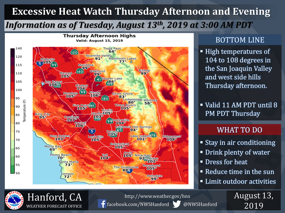
August 13, 2019 - The National Weather Service Hanford Office reports an Excessive Heat Watch is in effect for the San Joaquin Valley and west side hills from 11:00 A.M. until 8:00 P.M. Thursday.
High temperatures will be 104 to 108 degrees in the San Joaquin Valley and west side hills Thursday afternoon.
An Excessive Heat Watch means that a prolonged period of dangerously hot temperatures is expected. Heat related illnesses, such as heat exhaustion and heat stroke will be possible.
Drink plenty of fluids, stay out of the sun, and remain in an air-conditioned room.
  Area Forecast Discussion
  National Weather Service Hanford CA
  147 AM PDT Tue Aug 13 2019


  .SYNOPSIS...
  Widespread triple digit heat is expected in the San Joaquin Valley
  Today through Friday with the warmest day being Thursday.
  Temperatures will trend downward this weekend. Dry weather will
  persist across Central California through at least the next seven
  days.

  &&

  .DISCUSSION...
  An area of high pressure aloft over the South Central United
  States will retrograde westward tonight through Tuesday night.
  This upper-level area of high pressure will become anchored over
  the Desert Southwest Wednesday and will remain in place over the
  Desert Southwest Wednesday night through Friday. Widespread triple
  digit heat is expected in the San Joaquin Valley today through
  Friday.

  Thursday looks like it will be the hottest day of the week with
  high temperatures Thursday afternoon throughout Central
  California around ten degrees above normal for this time of year.
  In addition, high temperatures Thursday afternoon in Fresno and
  Bakersfield should be within a few degrees of the daily records
  for maximum temperatures in Fresno and Bakersfield. The current
  record for maximum temperature ever observed in Fresno on August
  15th is 109 degrees, set in 1920. The current record for maximum
  temperature ever observed in Bakersfield on August 15th is 110
  degrees, set in 1906. An Excessive Heat Watch has been issued for
  Thursday afternoon and early evening.

  An upper-level trough of low pressure near the coast of the
  Pacific Northwest will move southward Friday afternoon and night.
  This trough of low pressure aloft should remain in the general
  vicinity of the northern coast of California this weekend. This
  will allow temperatures to return to seasonal values this weekend.
  Maximum temperatures Saturday afternoon throughout Central California
  should be around ten degrees lower than Friday afternoon. Dry weather
  will persist through at least the next seven days.
Source: NWS

