


Wednesday Weather for Mariposa:
Sunny and hot, with a high near 100. Calm wind becoming west around 5 mph in the afternoon.
Tonight: Clear, with a low around 71. Northwest wind around 5 mph becoming northeast after midnight.
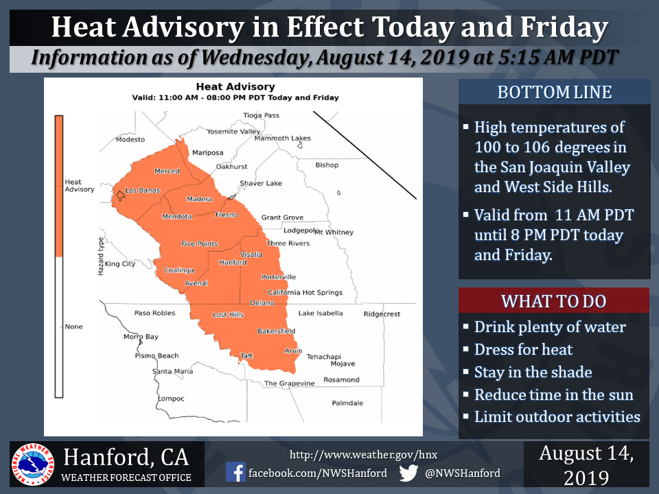
August 14, 2019 - The National Weather Service Hanford Office reports a Heat Advisory is in effect for the San Joaquin Valley and West Side Hills from 11:00 A.M. until 8:00 P.M. Wednesday and again on Friday.
High temperatures of 100 to 106 degrees are expected in the San Joaquin Valley and West Side Hills on these days.
Heat sensitive people and those who are new to the area will be most prone to heat illness.
Dehydration and prolonged exposure or strenuous physical activity outdoors during the hottest time of the day could lead to heat exhaustion and/or heat stroke.
If you have to be outside during this time, wear sunscreen, drink plenty of water, and wear light colored, loose fitting clothing.
Heat Advisory
URGENT - WEATHER MESSAGE
National Weather Service Hanford CA
441 AM PDT Wed Aug 14 2019


West Side Hills-San Joaquin Confluence-Merced and Madera-
Western San Joaquin Valley-Foggy Bottom-Fresno-Tulare County-
Southern Kings County-Western Kern County-Eastern Kern County-
Bakersfield-
Including the cities of Avenal, Coalinga, Los Banos, Mendota,
Merced, Five Points, Hanford, Lemoore, Corcoran, Fresno, Goshen,
Visalia, Alpaugh, Delano, and Bakersfield
441 AM PDT Wed Aug 14 2019

...HEAT ADVISORY REMAINS IN EFFECT FROM 11 AM THIS MORNING TO
8 PM PDT THIS EVENING...
...EXCESSIVE HEAT WARNING REMAINS IN EFFECT FROM 11 AM TO 8 PM
PDT THURSDAY...
...HEAT ADVISORY REMAINS IN EFFECT FROM 11 AM TO 8 PM PDT
FRIDAY...

* TEMPERATURES...100 to 106 Wednesday and Friday. 103 to 109
  Thursday.

* TIMING...Hottest temperatures occurring between 11 AM and 8 PM
  each day.

* IMPACTS...The hot temperatures can cause heat stress during
  outdoor exertion or extended exposure. Power infrastructure
  and systems may be stressed due to the increase in electrical
  consumption.

PRECAUTIONARY/PREPAREDNESS ACTIONS...

Take extra precautions, if you work or spend time outside. When
possible, reschedule strenuous activities to early morning or
evening. Know the signs and symptoms of heat exhaustion and heat
stroke. Wear light weight and loose fitting clothing when
possible and drink plenty of water.

Young children and pets should never be left unattended in
vehicles under any circumstances. This is especially true during
warm or hot weather when car interiors can reach lethal
temperatures in a matter of minutes.
Area Forecast Discussion
  National Weather Service Hanford CA
  216 AM PDT Wed Aug 14 2019


  .SYNOPSIS...
  Widespread triple digit heat will continue in the San Joaquin
  Valley through Friday with the hottest day being Thursday.
  Temperatures will drop to near normal this weekend before
  trending back upward early next week. Dry weather will persist
  across Central California through at least the next seven days.

  &&

  .DISCUSSION...
  A ridge of high pressure will continue to strengthen over the
  region today and Thursday bringing clear skies and warming
  temperatures. Temperatures rose into the triple digits many areas
  of the San Joaquin Valley Tuesday, and expect all areas of the
  Valley to be in the triple digits today. As the ridge continues to
  strengthen, temperatures will warm even a few more degrees
  Thursday, which is expected to be the hottest day of the week.
  Temperatures will be 5-10 degrees above normal across the entire
  central California interior on Thursday. The excessive heat
  warning remains in effect for the San Joaquin Valley and Westside
  Hills Thursday with a heat advisory for the Sierra Foothills. With
  Wednesday and Friday being almost as warm, will continue with the
  heat advisories for the San Joaquin Valley and Westside Hills for
  those days.

  Friday night and Saturday, a trough of low pressure deepening
  along the west coast will weaken the ridge slightly and allow some
  marine cooled air to spill into the San Joaquin Valley. Thus,
  temperatures will cool back to normal for Saturday and cool a few
  more degrees Sunday.

  The cooler temperatures will not last long as the ridge of high
  pressure begins to build right back into California early next
  week, warming temperatures back toward 100 by next Wednesday.
  With no influx of moisture into the region, the forecast remains
  free of precipitation for at least the next seven days.
Source: NWS

