


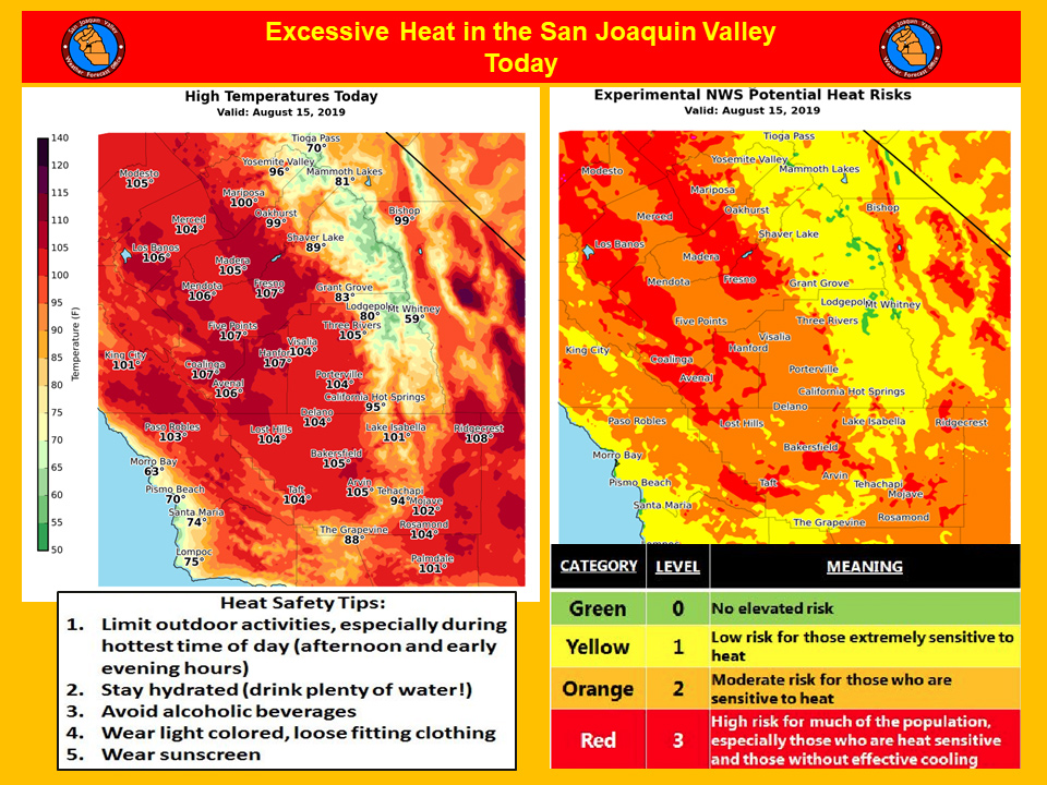
Under Potential Heat Risks, Mariposa County and Madera County have locations that are high risk for much of the population, especially those who are heat sensitive and those without effective cooling today.
August 15, 2019 - The National Weather Service Hanford Office reports today will be the hottest day this week with high temperatures of 104 to 109 degrees in the San Joaquin Valley.
Temperatures this hot pose a high heat risk, especially for those with respiratory ailments, the elderly and those individuals that are not acclimated to hot weather.
If you’re going to be outdoors during the hottest time of the day (between 1 pm and 6 pm), avoid strenuous exercise, stay hydrated and wear light colored, loose fitting clothing.
Never leave pets or young children unattended in a car.
  Area Forecast Discussion
  National Weather Service Hanford CA
  207 AM PDT Thu Aug 15 2019


  .SYNOPSIS...
  Widespread triple digit heat will continue in the San Joaquin
  Valley through Friday with the hottest day being today.
  Temperatures will drop to near normal this weekend before trending
  upward again on Tuesday. Dry weather will persist across Central
  California through at least the next seven days.

  &&

  .DISCUSSION...
  Very little change in the forecast this morning. High pressure
  continues to dominate the weather pattern with plenty of sunshine
  and above normal temperatures. Today is expected to be the hottest
  day of this week with highs 103-110 in the San Joaquin Valley and
  Westside Hills as well as in the Kern county desert areas. Even
  much of the Sierra Foothills will be in the triple digits this
  afternoon. Heat warnings and advisories remain in effect. People
  are reminded to limit outdoor activities, especially during the
  afternoon and early evening hours. If you must be outside, wear
  light colored, loose fitting clothing and bring plenty of water to
  remain hydrated. Temperatures will nudge downward slightly Friday,
  but will still be hot. So another Heat Advisory is in effect for
  the San Joaquin Valley and Westside Hills on Friday.

  A weak upper trough will drop down into the Pacific Northwest and
  along the California coast this weekend. This will temporarily
  push the high out of the way and allow for a cooling trend through
  the weekend. Temperatures will return to near normal on Saturday,
  then cool just a few more degrees Sunday with little change on
  Monday. By Tuesday, the ridge of high pressure builds back into
  California and temperatures begin to warm again. We should see
  high temperatures near 100 degrees again by Wednesday.

  A dry forecast continues with no moisture in site for central
  California for at least the next seven days.
Source: NWS

