


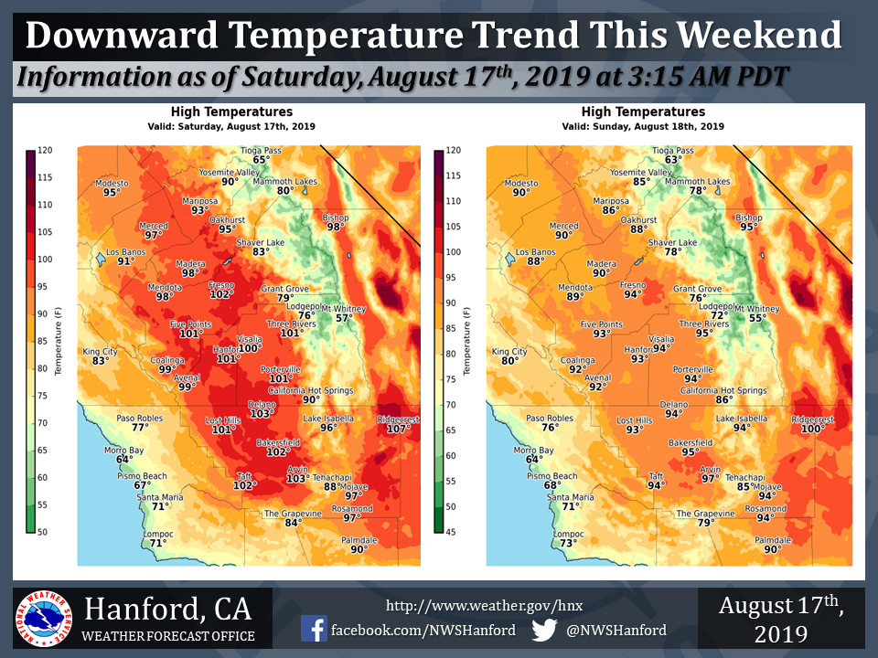
Mariposa projected high temperature for Saturday: 93 degrees and Sunday: 86 degrees
Oakhurst projected high temperature for Saturday: 95 degrees and Sunday: 88 degrees
Yosemite Valley projected high temperature for Saturday: 90 degrees and Sunday: 85 degrees
August 17, 2019 - The National Weather Service Hanford Office reports maximum temperatures this afternoon will be around five degrees lower than yesterday afternoon.
Be that as it may, high temperatures this afternoon will be about five degrees above normal for this time of year.
Maximum temperatures Sunday afternoon will be six to eight degrees lower than this afternoon.
High temperatures Sunday afternoon will be slightly below their typical values for the latter half of August.
  Area Forecast Discussion
  National Weather Service Hanford CA
  330 AM PDT Sat Aug 17 2019

  .SYNOPSIS...Dry weather can be expected over the central
  California interior for the next several days. Temperatures
  will cool to near normal by Sunday and Monday. Hot weather
  will return during the mid to later part of next week with
  highs above 100 degrees in the San Joaquin Valley, lower
  foothills and the Kern county desert.

  &&

  .DISCUSSION...The stage is set for a significant cooling trend
  over the central California interior during the next few days.
  As of this writing, temperatures are already trending 3 to as
  much as 15 degrees lower than 24 hours ago over the northern half
  of the state. Brisk winds are blowing through the Sacramento
  Delta this morning and gusting as high as 30 mph at Travis AFB.
  The marine layer along the central California coast is deepening
  as of this writing and time lapse satellite imagery shows the
  inland invasion of low stratus into the coastal valleys. These
  are excellent indicators of a definitively cool change in the
  weather across the entire CWA during the next 24 to 48 hours.
  We can credit this cooling to an upper level trough over the
  Pacific Northwest. The trough will settle southward into the
  Golden State this weekend and finally shove the high pressure
  ridge that`s been baking us into Texas.

  Although cooler air will be infiltrating our CWA today, high
  temperatures will still top the century mark over the southern
  half of the San Joaquin Valley, the lower foothills of Tulare
  County and the Kern county desert but it will be the last day of
  triple digit heat in any part of our CWA until the middle of next
  week. Sorry about that spoiler. Yes, 100-degree heat will indeed
  make its return by Wednesday or Thursday in the San Joaquin
  Valley, lower foothills and the Kern county desert, so enjoy the
  short-lived cool down. Sunday and Monday will be the coolest days
  in this pattern with highs in the upper 80s to lower 90s in the
  San Joaquin Valley. Minimum temperatures in the valley will be
  very comfortable during this period with lows ranging from the
  mid 50s to mid 60s. In the Kern county desert, afternoon high
  temperatures will stay below the century mark Sunday and Monday
  with lows generally in the 60s. Additionally, the cool change
  will be accompanied by gusty west to northwest winds this weekend.
  Gusts of up to 35 mph are likely through and below the passes on
  the west side of the San Joaquin Valley this afternoon and evening
  with a possible recurrence late Sunday into Sunday night. The
  winds could also kick up some dust in a few locations west of
  Interstate 5. In the Kern County mountains and desert, westerly
  winds could gust to 40 mph or higher through and below the passes
  this weekend.

  The onshore flow will dwindle Monday and become offshore again
  by Monday night or Tuesday as the high pressure ridge over
  Texas begins to builds westward. As the ridge retrogrades next
  week, it will inevitably put us back in the frying pan. As we`ve
  already indicated, widespread triple digit heat will return to
  elevations at and below 2500 feet by Thursday. The pattern will
  likely stagnate across central California in the 5 to 7 day period
  as the high pressure ridge remains in control. During that time,
  the models forecast an increase in activity over the tropical
  regions of the eastern Pacific with the possibility of a named
  cyclone near the Baja peninsula. Whether or not tropical moisture
  from this system moves northward into California by next weekend
  is questionable, but it`s worth watching. Otherwise, it appears
  that the high pressure ridge over the southwestern U.S. will keep
  central California dry in the extended forecast period.
Source: NWS

