


Mariposa projected high temperature for Sunday: 85 degrees and Monday: 85 degrees
Oakhurst projected high temperature for Sunday: 88 degrees and Monday: 88 degrees
Yosemite Valley projected high temperature for Sunday: 83 degrees and Monday: 83 degrees
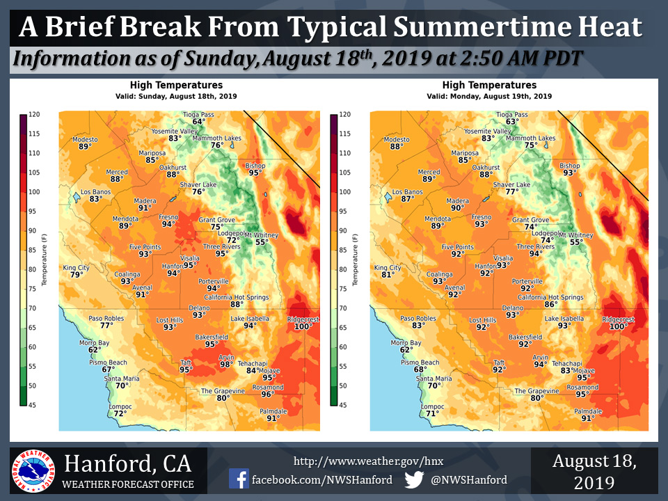
August 18, 2019 - The National Weather Service Hanford Office reports high temperatures this afternoon and Monday afternoon throughout Central California will be a few degrees below normal for this time of year.
Gradual warming is expected Tuesday and Wednesday. Widespread triple digit heat will likely return to the San Joaquin Valley Thursday.
  Area Forecast Discussion
  National Weather Service Hanford CA
  323 AM PDT Sun Aug 18 2019

  .SYNOPSIS...Dry weather can be expected over the central
  California interior for the next several days. Temperatures
  will average slightly cooler than normal through Monday.
  A warming trend can be expected for the remainder of the
  week with temperatures ending up several degrees above normal
  by Thursday.

  &&

  .DISCUSSION...A cooler and refreshing change in the weather is
  in store for us during the next couple of days thanks to an
  onshore flow. A deep marine layer exists along the central
  California coast this morning. Time lapse satellite imagery shows
  ocean stratus moving into coastal valleys and extending as far
  inland as the foot of Pacheco Pass. Brisk winds are still blowing
  through the Sacramento delta as of this writing and will likely
  continue through at least this evening while we remain under a dry
  southwesterly flow aloft. The best part of our current weather
  pattern is that the onshore flow will bring ocean cooled air into
  the entire San Joaquin Valley and lower foothills for at least
  another 36 hours. Some of this modified marine air will even spill
  below the Kern county mountain passes into the Mojave desert where
  high temperatures will remain below the century mark. San Joaquin
  Valley residents will benefit most from this onshore flow today
  and Monday with highs ranging from the mid 80s in Merced County to
  the lower 90s elsewhere and overnight lows in the mid 50s to mid
  60s. Winds will be locally gusty through and below the passes on
  the west side of the San Joaquin Valley and in Kern county through
  this evening but will generally remain below advisory levels.

  Our respite from hot weather won`t last very long, however. The
  upper level ridge of high pressure that baked us last week will
  gradually build back over the Golden State during the mid to later
  part of the week. The ridge will be centered over Texas during
  the next 2-3 days but its retrogression will bring widespread triple
  digit heat back into the Kern county desert Wednesday and in the
  San Joaquin Valley and lower foothills beginning Thursday. Friday
  through next Sunday could be equally as hot as last week as the
  ridge strengthens over central California. Otherwise, our weather
  will remain dry for at least the next 7 days.

  In the meantime, the tropical Eastern Pacific will likely become
  more active next week after a relatively dormant period. The
  models forecast the development of a rather strong tropical
  cyclone off the central Mexican coast which could threaten the
  southern Baja peninsula by the end of the week. High pressure
  ridges generally strengthen to the north of these systems, so that
  boosts our confidence of strong upper level ridging over central
  and southern California in the 5 to 7 day period.
Source: NWS

