


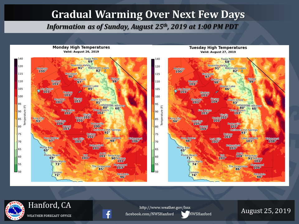
Mariposa projected high temperature for Monday: 96 degrees, Tuesday: 97 degrees
Oakhurst projected high temperature for Monday: 97 degrees, Tuesday: 98 degrees
Yosemite Valley projected high temperature for Monday: 91 degrees, Tuesday: 91 degrees
August 25, 2019 - The National Weather Service Hanford Office reports temperatures will gradually warm over the next several days.
At this time Tuesday afternoon is expected to be the peak of the heat for this week.
Maximum temperatures the next several days will be several degrees above normal levels for this time of year.
Be sure to take proper precautions in the heat, such as staying hydrated and taking periodic breaks from the heat.
Never leave people or animals in an enclosed vehicle for even short periods as the temperatures inside of the vehicle can reach deadly levels very quickly.
  Area Forecast Discussion
  National Weather Service Hanford CA
  154 PM PDT Sun Aug 25 2019


  .SYNOPSIS...
  Ridge of high pressure remains over Central California today,
  meaning another day of above normal heat. This warming trend will
  continue early this week, with Tuesday being the hottest day of
  the week. Modest cooling trend starting Wednesday due to an upper
  level trough weakening the ridge over California. Additionally,
  there is a slight chance of afternoon convection over the Sierra
  Nevada Tuesday and Wednesday afternoon.

  &&

  .DISCUSSION...
  With the northern stream remaining fairly active across the
  northern CONUS. Here in our neck of the woods we are quite the
  opposite. Ridging has continued to build into the region and
  temperatures are gradually rising in response along with clear to
  mostly clear conditions. This warming will continue through at
  least Tuesday when we expect the peak to the warming to take
  place. The remains of the tropical system Ivo will bring a
  weakness along the western periphery of the ridging as it moves
  northward and is pushed inland over northern California. This
  weakness will allow temperatures to synoptically cool and even
  bring in some high clouds that will also help to keep temperatures
  lower for mid to later part of the week. A few showers and even a
  thunderstorm or two will be possible over the highest parts of the
  Sierra as the tropical remnants get pushed inland late Tuesday
  afternoon and into Wednesday afternoon. High pressure then
  reasserts its dominance back into the region into the weekend once
  again slightly warming temperatures back up.

  Looking further into the future, there are the makings of a more
  blocky pattern across the western third of the CONUS. This could
  considerably slow things down in the atmosphere and push the
  timing further back on guidance. That also could keep high
  pressure over the region a bit longer and keep things warm around
  here well into next week. However, a fairly strong trough progged
  to move into the Pacific Northwest could break things up. So a
  little bit of uncertainty in longer term.
Source: NWS

