


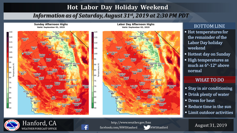
Mariposa projected high temperature for Sunday: 96 degrees, Monday: 95 degrees
Oakhurst projected high temperature for Sunday: 96 degrees, Monday: 95 degrees
Yosemite Valley projected high temperature for Sunday: 89 degrees, Monday: 88 degrees
September 1, 2019 - The National Weather Service Hanford Office reports a warming trend will persist into Sunday, with hot temperatures continuing on Labor Day.
High temperatures will reach as much as 6 to 12 degrees above normal for this time of year.
During this hot period, remember to drink plenty of fluids and limit outdoor exertion. Try to spend time in an air-conditioned room and avoid prolonged exposure to the sun.
  Area Forecast Discussion
  National Weather Service Hanford CA
  155 AM PDT Sun Sep 1 2019


  .SYNOPSIS...
  High pressure over Central California will keep the forecast area
  warm through Labor Day. A trough of low pressure approaching the
  Pacific Coast will bring slightly cooler weather across the San
  Joaquin Valley by Tuesday, along with a chance of afternoon
  showers and thunderstorms across the Sierra Nevada Tuesday through
  Thursday.

  &&

  .DISCUSSION...
  Yesterday was another hot day across Central California, and a few
  spots in the San Joaquin Valley reached into the triple digits
  (such as Fresno and Hanford). Hot and dry weather continues today
  and again on Labor Day. Expect little change in temperatures;
  however, highs are expected to warm slightly today as high
  pressure remains in control.

  Expect gradually lowering temperatures on Tuesday through the end
  of the week. The ridge of high pressure will be slow to weaken
  initially, while the upper-level trough approaches the West Coast.
  Thus, high temperatures on Tuesday will likely lower only by a
  couple of degrees. Mid-level monsoonal moisture with a south-
  southeasterly flow aloft is progged to occur by Tuesday and will
  be sufficient for at least scattered showers and thunderstorms
  over the Sierra Nevada with isolated storms possible over parts of
  the adjacent foothills during the afternoon and evening. Also, the
  Storm Prediction Center`s Day 3 (Tuesday`s) outlook depicts at
  least a mention of thunder in this area, as well as the desert
  portions of southeastern California. Expect little change in the
  weather pattern on Wednesday with another chance for Sierra
  thunderstorms during the afternoon and evening. Otherwise, some
  increase in mid- level cloudiness is possible at times on Tuesday
  and Wednesday.

  The upper level trough will pass over the region and northern
  California late Wednesday into Thursday. Models are consistent in
  keeping the monsoonal moisture flowing into our region, so the
  threat of showers and thunderstorms will continue over the Sierra
  Nevada during Thursday afternoon and evening. The approaching
  trough could push some of the moisture towards the east, so a
  threat for isolated thunderstorms is anticipated mainly for
  southern portions of the Sierra Nevada and into Kern County.
  Models are in a bit of disagreement in terms of placement and
  trajectory of the trough and its associated low pressure center,
  so monsoonal moisture could linger over parts of the Sierra into
  Friday.

  Highs will lower towards seasonal averages by next weekend as
  another trough of low pressure approaches Northern California and
  the Pacific Northwest. This trough is forecast to dig southward by
  next Sunday, so temperatures may lower even more. This appears to
  be a mainly dry pattern for us at this time, except for perhaps
  showers around Yosemite and some increased winds.

  Regarding Hurricane Dorian, please visit hurricanes.gov for the
  latest details.
Source: NWS

