


Temperatures slightly above normal, mainly across inland areas.
Chance of a delayed start to the winter “rainy season”
Near normal number of offshore wind events expected through December
Weather DIscussion
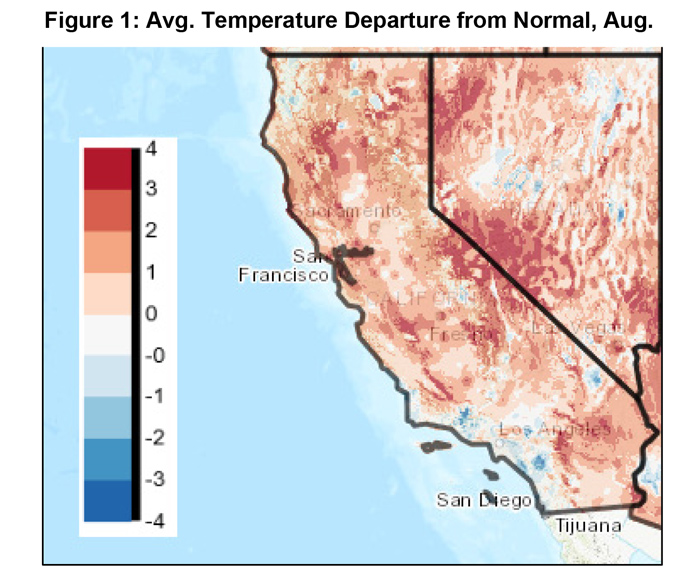
September 3, 2019 - Temperatures ran far above normal during this past August (Figure 1, below). This deviation from normal was most keenly felt during the daylight hours as
 opposed to temperatures being “contaminated” by spuriously warm overnight lows in the pervasively dry atmosphere of summer 2019. Mostly sunny skies were observed most days away from the marine layer and long summer days allowed maximum temperatures to soar to well above normal readings more often than not in August. Fortunately, the Geographic Area was spared the scorching temperatures more typical of August due to a persistent onshore flow.
The summer monsoon continued to be missing in action as southwesterly flow proved stubborn the past 30 days. A series of troughs continued to move past the Pacific Northwest quite frequently in August. While these systems were too far north to produce any rainfall, the steering winds aloft kept subtropical moisture stifled east of the district. On the rare occurrence when the upper level pattern became more conducive for monsoonal flow, the source region over Mexico was strangely deprived of significant moisture. Thus, both the steering wind and moisture inputs were hostile to the formation of thunderstorms. At this late date in the “monsoon season” only a fleeting bought or two of moisture is expected the rest of the summer and meaningful rainfall from convection is not expected going into the fall.
This last summer continued the trend we’ve been seeing since 2010 where much fewer than normal summer storms occurred after wet winters (and vice versa). But one may be asking - does a dry summer signify a possibility of a wet winter?
The short answer to this supposition is no. In fact, sea surface temperatures (SST) are aligning in a non-favorable pattern for the production of rainfall this winter. The weakly positive ENSO signal which persisted through the summer has since dissipated as SST’s have rapidly cooled off the coast of South America. For now, the ENSO is in neither an El Niño nor La Niña state (although if trends continue, we may be looking at a Modoki El Niño or a La Niña in a few months) and it is unlikely equatorial SST’s will have much bearing on this winter’s weather.
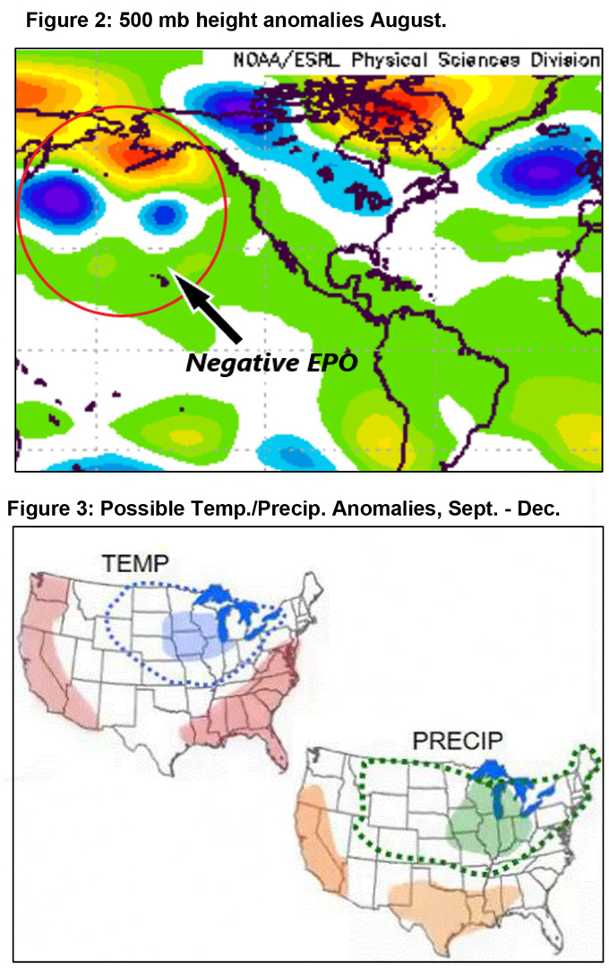
Instead, the presence of a negative Eastern Pacific Oscillation (- EPO) may be a stronger driver of upper level patterns this winter (Figure 2, below). In these instances, much of the West Coast ends up drier than normal in the winter as high pressure over the Gulf of Alaska ends up blocking the storm track or shifting it away from the area. Should this occur, a later start to the “winter rainy season” may be in the cards this year. Models have been picking up on this trend as several NMME members point toward drier than normal weather in December at the current time. Long range outlooks produced in collaboration with SWCC and SACC indicate nearly the same thing (Figure 3, below).
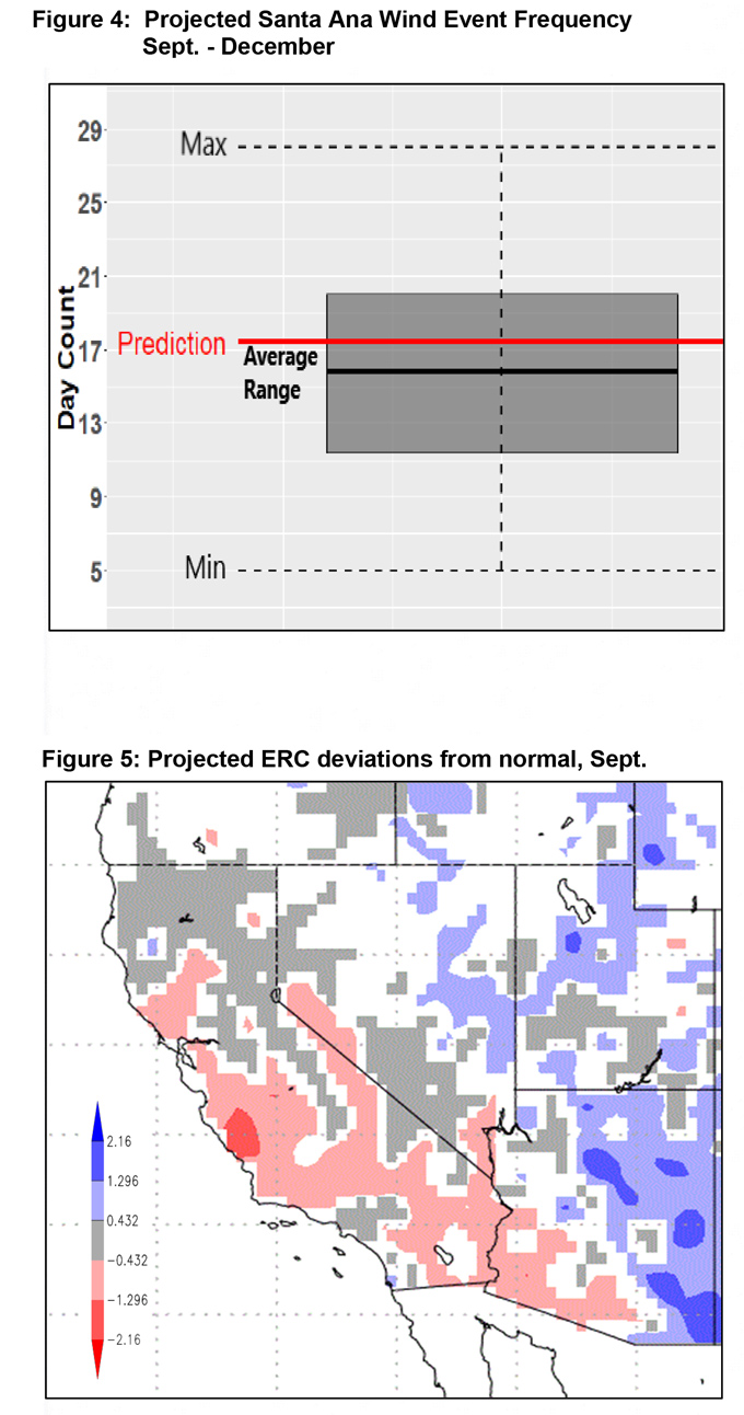
Offshore wind events are expected to occur at a near to slightly above normal rate through the end of the year (Figure 4, below). Ordinarily, there are 1 offshore wind days in September on average and 16 encompassing the time period September through the end of December.
This year’s prediction calls for around 2 days and around 16 days in September and for Sept.–Dec. timeframe, respectively. A prediction of a near normal rate of occurrence stands in contrast to the previous two seasons which have been at both ends of the spectrum. This same forecasting tool was quite accurate in its outlook of a well above normal number of days in 2017 and a well below normal number in 2018. Whatever the count ends up being this year, barring the influence of a dissipating tropical storm, offshore winds will almost certainly arrive well before the onset of meaningful rainfall this fall.
FUELS AND DROUGHT OUTLOOK
Buoyed by a wet winter and a cool, damp spring, live fuel moisture has been slow to dry compared to most years. Most reports from the field indicate live fuel moisture is running 2-4 weeks behind average with moisture values aligning closer with values more typically seen in mid-July. Dead fuel moisture has taken a steep tumble over the summer, largely due to the absence of summer convection and its associated cloudy and more humid days. Strong drying conditions, instead of raindrops, was more commonplace this summer.
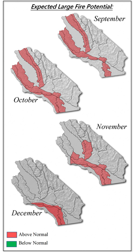
Warm, dry weather along with periodic outbreaks of offshore winds should bring live fuel moisture in closer alignment to values typical of September. Thus, there is a high likelihood of live fuels becoming critically dry around the end of September. So far this season, live fuel moisture has been an inhibitor to fire growth. But by early October, live fuel moisture may cross a threshold which is no longer sufficient to arrest fire growth. Forecast ERC charts (Figure 5, below) bear this out as both long range weather models and fuel moisture curves show higher than normal fire activity potential during peak heating hours.
Thus, after a long stretch of relatively quiescent fire weather conditions and moderate levels of fuel ignition receptivity and carrying potential, fire behavior may make a quick turn toward being more aggressive. Expect rapid rates of spread (in contrast with the moderate ROS this summer) during hot, dry or windy periods. Long range models also indicate hotter than average weather is expected this fall, so the short periods of hot weather we’ve been graced with this summer may transform into extended periods of above normal temperatures. Given these weather and fuel assumptions, we have high confidence of an above normal large fire potential this fall into early winter. Large fire potential should decrease from north to south, as it usually does, albeit a few weeks later than usual. It might be well into December before Southern California sees potential fall to normal levels.
Source: Predictive Services

