


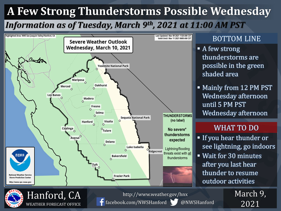
Includes Mariposa, Oakhurst and Yosemite National Park
March 9, 2021 - The National Weather Service Hanford Office reports a few strong thunderstorms are possible in most of Central California Wednesday.
In addition to dangerous lightning strikes, small hail, and wind gusts near 45 mph, any thunderstorm can produce intense rainfall rates, leading to localized flooding.
  Area Forecast Discussion
  National Weather Service Hanford CA
  1025 AM PST Tue Mar 9 2021

  .Updated to add Wind Advisory for the Kern County mountains and
  desert...

  &&

  .SYNOPSIS...A slow moving storm system will bring cooler
  conditions and precipitation this afternoon through Thursday.
  There is a slight chance of thunderstorms Wednesday afternoon and
  evening, mainly across the San Joaquin Valley. Dry weather along
  with a warming trend are likely Friday into the weekend.

  &&

  .DISCUSSION...Strong upper level jet to the south of a cold core
  low currently situated off the Pacific Northwest coast will
  support strong southwest to west winds through and below the Kern
  County mountain passes through 10 pm this evening. As the cold
  core low and the associated upper level jet migrate southward,
  winds will diminish in the advisory area tonight. Otherwise, we
  expect an increase in convection over much of our CWA, especially
  the mountains, as the cold core low drifts southeastward during
  the next 24 to 36 hours.

  &&


  .PREV DISCUSSION... /issued 435 AM PST Tue Mar 9 2021/

  Satellite images show a southwest flow bringing mid and upper
  moisture into central CA this morning. Radar picking up on a few
  showers off the Monterrey coast as a short wave approaches the
  coast. This feature is well south of the main core low which is
  still off the CA/OR coast. The initial disturbance will bring an
  increasing threat of precipitation this afternoon. Models indicate
  some instability for possible thunder towards the Merced area.
  The cold core low moves south along the CA coast through Thursday.
  The heavier precipitation may occur early Wednesday morning with
  the low situated off the North CA coast placing central CA in a
  favorable dynamic area of the upper trough along with a SSW flow
  providing additional forcing due to orographic lift over the
  sierra mountains. Models show more widespread instability across
  central CA Wednesday afternoon with pretty unstable conditions
  with lapse rates of 8.5C/KM at mid level. Isolated thunder will be
  more probable Wednesday afternoon across the San Joaquin Valley
  and towards the coast. Winds finally turn North as the low
  approaches Point Conception Thursday morning and over S CA
  Thursday afternoon. Latest guidance for precipitation amountgs is
  slightly less but still prog up to one inch and half over the
  parts of the sierra high country. Snow levels will be relatively
  low around 4kft this afternoon and lower to road pass level around
  3-3.5kft tonight. Thus Kern county mountain road passes could see
  impacts Wednesday morning. A stronger offshore flow develop over
  the sierra Thursday night as the trough moves onshore over SCal.
  Weak to moderate Mono wind may be possible into Friday morning.
  Models are in poor agreement for the latter part of the forecast.
  But general consensus is for an upper ridge along the EPac
  shifting inland over the area during the weekend bringing a drier
  and warming trend.
Source: NWS
