


California and National Drought Summary for May 25, 2021
Summary
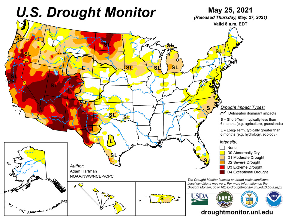
May 27, 2021 - Much of the western CONUS experienced below-normal average temperatures this week, with many areas across the Great Basin and Northern Rockies observing greater than 6°F negative departures. Above-normal precipitation in the West was limited to the high elevations of the Cascades, the Central Great Basin, Montana, and northern New Mexico. However, improvements were only warranted in western Montana and northern parts of New Mexico, where the heaviest precipitation fell. Elsewhere in the West, degradations were warranted due to declining snowpack, stream flows, and soil moisture. The Southern Plains and Gulf Coast also experienced negative 7-day average temperature departures. However, negative departures along the eastern Gulf Coast were driven by easterly to northeasterly flow early in the week whereas below-normal temperatures along the western Gulf Coast and Southern Plains were driven by above-normal precipitation (1 to 2 inches across the Southern Plains and well in excess of 3 inches through the Ark-La-Tex and along the western Gulf Coast). Heavy rains in the Southern Plains resulted in continued improvements across Texas this week, while high pressure across the Southeast exacerbated 30 to 60-day dryness in Virginia, the Carolinas, and Florida, leading to degradation of abnormally dry (D0) and moderate drought (D1) conditions. From the Central and Northern Plains eastward to the Atlantic Coast, most areas experienced temperatures 6°F to 9°F above-normal. Heavy rains fell across western portions of the High Plains Region, warranting minor improvements across the western Dakotas, while the larger improvements were observed from western Nebraska and Kansas westward to the Front Range. From the eastern High Plains Region to the Great Lakes, improvement and degradations were observed based on where the heaviest precipitation fell. In the Mid-Atlantic and Northeast, below-normal precipitation over the past couple of weeks and above-normal average temperatures this week resulted in D0 expansion from the Great Lakes to New England and into the Mid-Atlantic, with some D1 expansion in Upstate New York. Stream flows and soil moisture continue to rapidly decline across the Northeast, Mid-Atlantic, and portions of the Southeast.
Northeast
This week, above-normal temperatures (6°F to 12°F positive departures) and below-normal precipitation (0.5 to 2 inch negative departures) were widespread across the Northeast. USGS 7-day average stream flows have fallen below the 10th percentile across much of western and Upstate New York, New England, and the Mid-Atlantic. CPC soil moisture has also continued to fall to below the 10th percentile across Upstate New York, northern Vermont and New Hampshire, and southern Maine, corroborated by NASA SPoRT 0-200 cm soil moisture percentiles. Therefore, portions of western and Upstate New York and New England were downgraded to abnormally dry (D0) conditions this week, with some D1 (moderate drought) expansion in Upstate New York. Farther southward from Connecticut southwestward into the Mid-Atlantic, 30 to 60-day precipitation deficits (3 to 5 inches over the last 60 days) continue to accumulate, resulting in D1-D4 equivalent 30 to 60 day SPIs, and 7-day average stream flows falling below the 10th percentile in many of these areas. Soil moisture has also begun to rapidly decline, due to the above-normal temperatures this week. As such D0 was expanded across western Connecticut, portions of the Mid-Atlantic coast and Delmarva Peninsula, southeastern Pennsylvania, and central and western Maryland.
Southeast
Average temperature anomalies ranged from 4°F to 6°F above-normal in northern Virginia to 2°F to 4°F below-normal southward from South Carolina to Florida. Despite cooler than normal conditions for many southern areas of the Southeast, there were a few very warm days along the eastern seaboard, with highs reaching into the low-to-mid 90s, further exacerbating the increasing dryness over the past 60 to 90 days, particularly across Virginia and the Carolinas. Additionally, little to no precipitation was observed across most of the Southeast this week. With D3-D4 equivalent 30-day SPIs, 60-day SPIs continuing to fall, USGS 7-day average stream flows falling below-normal (10th to 24th percentile) and much below-normal (below the 10th percentile), and with having received 25 to 50 percent of normal precipitation (per AHPS), D1 (moderate drought) was expanded to cover much of eastern North Carolina and southeastern Virginia. D0 (abnormal dryness) was also expanded farther westward from Virginia toward the Ohio and Tennessee Valleys, as short-term dryness has begun to diminish stream flows (falling below the 24th percentile) in those areas. In South Carolina, some minor expansion of D0 and D1 has continued as soil moisture continues to dry out, exacerbated by this week’s warm spell, and based on 7-day rainfall totals and 30 to 60-day rainfall deficits. D0 and D1 areas were also modified in a similar manner across the southern Florida Peninsula for similar reasoning. Furthermore, fire risk is elevated across southern Florida, with a burn ban now in place for Collier County, along the southern Florida Gulf Coast. The Tennessee Valley has also continued to dry out in the last 30 days causing browning of vegetation in areas of extreme northwestern Alabama, extending northward into Tennessee, warranting D0 introduction. Elsewhere in the Southeast, sufficient 30 to 90-day rainfall totals and weak average temperature anomalies (+ or – 4°F) warranted a status quo depiction this week.
South
Heavy rainfall and flooding was the main concern for many locations in the Southern Region this week. Across eastern and southern Texas, the Ark-La-Tex, and southwestern Louisiana, many areas received in excess of 3 inches of rainfall this week, in addition to the heavy rainfall observed in recent weeks. Southeastern Texas and southwestern Louisiana were again some of the hardest hit areas, with several areas receiving 8 to 10 inches of rainfall, and more in some locations. The eastern half of Texas, although having become drought free this week, has switched to become excessively wet, with flooding ongoing in several areas. Farther west in Texas, further reductions in D0 (abnormally dry) and drought (D1-D4) coverage were warranted in areas receiving more than 2 inches of rainfall, and some green-up has been indicated across parts of western Texas in recent weeks. From northern Mississippi to central Tennessee, 30-day rainfall deficits are beginning to increase. D0 was introduced in south-central Tennessee, extending across into northwestern Alabama, as 30-day SPIs have fallen into the D0 to D1 range, despite near normal stream flows. This area also shows up well (D0 to D1 equivalent depictions) in the NASA SPoRT 0-100 cm soil moisture.
Midwest
Most rain fell across the western half of the Midwest Region this week, with some areas receiving in excess of 2 inches of rainfall. Most of the larger rainfall totals occurred in drought-free areas, but some D0 (abnormally dry) and D1 (moderate drought) reductions were warranted in southeast Minnesota and western Wisconsin, where some locations received more than 2.5 inches of rain. Unfortunately, for several abnormally dry and drought-stricken areas, precipitation remained below-normal this week, adding to short-term deficits. Coupled with above-normal average temperatures this week (9°F to 12°F positive anomalies) across the Great Lakes and Upper Midwest, increases in D0 coverage were warranted across western and central Minnesota and parts of the Arrowhead. Moderate drought (D1) was expanded from southeastern Michigan into northwestern Ohio also, as stream flows have fallen below the 10th percentile and soil moisture has continued to dry out in recent weeks (CPC soil moisture falling below the 20th percentile and NASA SPoRT 0-100cm depicting D4 conditions). D0 to D1 equivalent short-term (30 to 60-day) SPIs and below-normal (10th to 24th percentile) USGS 7-day average stream flows warranted expansion of D0 across central Indiana and the introduction of D0 across eastern Kentucky and southern Ohio.
High Plains
In the High Plains Region, a swath of 1.5 to 3 inches (locally more) of rain fell from western North Dakota southward to eastern Colorado and northwestern Kansas. This resulted in reductions in D0 (abnormally dry) and D1 (moderate drought) coverage in western Nebraska and eastern Colorado, with additional 1-category improvements in the drought depiction across southeastern Colorado. In the Dakotas, where long-term moderate (D1) to exceptional (D4 – South Dakota) drought is entrenched, the heavy rainfall, although beneficial, was only enough for minor reductions in D1 (moderate drought) to D3 (extreme drought) coverage in the western areas. Reports indicate much of this week’s heavy rains was immediately absorbed by the severely dry soils, with no runoff into empty dugouts or ponds. However, in some locations, the rain fell so quickly that it did not allow time for infiltration into the topsoils, resulting in erosion of topsoils. Furthermore, high wind events have increased the potential for evaporative loss of this moisture from the topsoils. Currently, very little vegetative matter is available for grazing, despite some isolated areas of green-up from recent rainfall. In eastern North Dakota, some D3 reduction was warranted in areas receiving more than 1.5 inches of rainfall, diminishing long-term deficits. However, in South Dakota, where above-normal temperatures (9°F to 12°F positive anomalies) and below-normal precipitation (less than 50 percent of normal precipitation), expansion of D0 (abnormally dry), D1 (moderate drought), and D2 (severe drought) coverage were warranted as 30-day SPIs have fallen to D3 to D4 equivalence and 30-day deficits (1 to 3 inches) continue to accumulate.
West
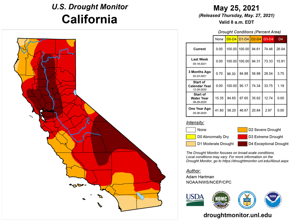
Most basin snow water equivalent (SWE) percentiles across the Western Region are well below-normal for the period of record (near and below the 65th percentile), especially in the Four Corners region (below the 5th percentile in Arizona and New Mexico). Only parts of the Pacific Northwest and areas of central Montana experienced near and above-normal seasonal snowfall. However, above-normal temperatures over much of the West in recent weeks to months has resulted in rapid snowmelt and, due to dry topsoils, much of the melt water has not made it into the rivers, lakes, and reservoirs. In California, USGS 7-day average stream flows across the coastal ranges around and north of the Bay Area, and extending eastward into the Sacramento River Basin, are rapidly declining having dropped below the 2nd percentile at many locations in the coastal ranges, and below the 10th percentile eastward into the northern Central Valley. CPC soil moisture ranks below the 1st percentile (corroborated by NASA SPoRT 0-200 cm soil moisture percentiles), NASA GRACE indicates severely depleted groundwater, and vegetation indices (VegDRI and VHI) indicate severe vegetation stress. Reports of reduced pasture forage, livestock requiring supplemental feed and/or being sold off are increasing. Additionally, stock ponds are running dry and farmers have been forced to haul water in several locations. There are also reports of increased well drilling in the Sacramento River Valley and groundwater levels have fallen so low near the Sacramento and San Joaquin River deltas that there is an increased risk of salt water intrusion. Given the worsening conditions, D4 (exceptional drought) was expanded eastward into the Sacramento River Basin from the coastal ranges in and around the Bay Area. Farther east, D3 (extreme drought) was expanded into the Lake Tahoe area, as rapid snowmelt has nearly eliminated remaining snowpack, resulting in declining stream flows in that region, which have fallen to below the 10th percentile at several stations. In northeastern California, D2 (severe drought) was expanded into the lower Klamath Watershed, as USGS 7-day average stream flows have fallen below the 10th percentile and groundwater remains severely depleted (D3 to D4 equivalent, per NASA GRACE). Furthermore, the Yurok Tribe Fisheries Department reported diseased juvenile fish during an annual assessment and project a catastrophic fish kill along the Klamath River.
Elsewhere across the Western Region, targeted degradations to D2 (severe) and D3 (extreme) drought in eastern Washington and D1 (moderate) and D2 drought in northeastern Oregon were made. CPC soil moisture indicates widespread soil moisture conditions below the 5th percentile and groundwater is depleted for many areas. These degradations also correspond well with VegDRI, which indicates increased stress on vegetation. Despite the poor soil moisture conditions, 7-day average stream flows remain near and below-normal across many areas east of the Cascades due to the near to above-normal seasonal snowpack leading into the summer months. Conversely, in Montana, above-normal precipitation (7-day accumulations in excess of 2 inches liquid water equivalent) fell across the western half of the state, with locally more than 5 inches falling near Flathead National Forest (per AHPS). The heavy rainfall resulted in targeted improvements in areas experiencing abnormally dry (D0), moderate drought (D1), and severe drought (D2) conditions. However, long-term deficits remain (10 inch liquid water equivalent deficits in some of the higher elevations of western Montana).
Caribbean
Heavy rains in excess of 2 inches fell across northern and eastern Puerto Rico, with locally higher (more than 8 inches) falling in eastern parts of the island. Heavier rains in the east eliminated deficits in and around northern Rio Grande, eastern Humacao, southeastern Naguabo, and southwestern Ceiba Counties. Despite many locations in north-central and northwestern Puerto Rico receiving 2 to 5 inches of rainfall, it was not enough to eliminate 6-month deficits (5 to 10 inches, per AHPS). Additionally, D0 was expanded southward from Hatillo and Arecibo Counties into the northern tip of Utuado County, as below-normal precipitation last week pushed 6-month deficits to 8 to 12 inches.
Severe drought continued to affect the US Virgin Islands this week. On May 14, 2021, a USDA Secretarial natural disaster declaration was issued for St. Thomas and St. John due to the recent drought.
This week St. Thomas had only 0.48 inch of rain at the Cyril E. King airport. It’s month-to-date (MTD) rainfall total was 2.31 inches or 94.7% of normal. However, its year-to-date (YTD) rainfall total of 7.69 inches was 69.4% of normal. The CoCoRaHS station at the Anna's Retreat 2.5 ESE had a weekly value of 0.82 inch of rain and a MTD value of 0.94 inch. SPI values at the 1, 3, and 9 months indicate drought free conditions, while the SPI at the 9 months is indicative of moderate drought for St. Thomas.
St. Croix reported a weekly total of 1.01 inches at the Henry Rohlsen airport, which fell all on May 23. This was a new daily record, surpassing the previous record of 0.96 inch in 1984. The MTD rainfall total was 1.26 inches or 41.9% of normal. The YTD rainfall total was 5.90 inches or 58.2% of normal rainfall. The CoCoRaHS stations across St. Croix had a weekly total of 0.48 inch (Christiansted 1.8 ESE) and 0.91 inch (Christiansted 1.6 E) and a MTD total of 0.62 inch and 1.23 inches, respectively. SPI values for 3, 6, 9, and 12 months were indicative of moderate to severe drought.
Similarly, St. John had a weekly rainfall total of 0.93 - 1.26 inches, depending on the CoCoRaHS station. MTD rainfall total was 1.76-2.43 inches and YTD values were over 8 inches for the different CoCoRaHS stations. SPI values for all levels were indicative of abnormally dry to extreme drought.
Pacific
Abnormal dryness (D0) continues for northern and eastern Mainland Alaska. Temperatures were near to below-normal and precipitation near-normal state-wide this week, with the exception of the North Slope, which saw 4°F to 6°F positive 7-day average temperature anomalies. Near and above-normal snowpack across most basins and near to above-normal stream flows warrant no changes to the depiction this week.
Moderate drought (D1) was introduced to southwestern Kauai and southern Oahu in Hawaii. Easterly trade winds persisted for much of the week and 7-day average temperatures were a few degrees above-normal for both islands. Lower pastures on the west-facing slopes on Kauai and Oahu have reported deteriorating conditions (corroborated by NDVI). Furthermore, USGS 7-day average stream flows have fallen below-normal (10th to 24th percentile) to much below-normal (below the 10th percentile) on southern Oahu.
The weather features across the U.S.-Affiliated Pacific Islands (USAPI) during this USDM week (05/19/21-05/25/21) included a monsoon trough which extended from the west across Palau and most of the Federated States of Micronesia (FSM); an Inter-Tropical Convergence Zone (ITCZ) with associated trade-wind convergence extending from the east across the southern Marshall Islands (RMI) and well into the FSM; and an upper-level trough with upper-level lows over northern portions of the Micronesian region. Added to this mix were smaller surface troughs and weak circulations, mostly over western Micronesia. The upper-level trough generated divergence aloft across the length of Micronesia which enhanced showers triggered by the surface convergence. South of the equator, a dry ridge of high pressure dominated the weather over American Samoa, with mainly diurnal island convection producing limited showers.
Satellite-based estimates of 7-day precipitation (QPE) showed a band of rain extending across Micronesia associated with the monsoon trough and ITCZ, and another broken band extending southeastward, from Indonesia to south of the Samoan Islands, associated with the South Pacific Convergence Zone (SPCZ). Areas of 1+ inches of rain extended the length of Micronesia, from the equator to 10 degrees North latitude, with patches of 2+ inches over western Micronesia and a large area of 4+ inches associated with the ITCZ over eastern FSM and southern RMI. A band of 2-4 inches extended north of 10 N over parts of eastern FSM. The QPE depicted wisps of precipitation extending across the Marianas, although this QPE product does not detect the warm-topped showers of the Marianas very well. The QPE showed an area of 1+ inches of rain south and west of the Samoan Islands, associated with the SPCZ, with wisps of precipitation extending northeast across American Samoa.
With rainfall totals at 5.80 inches for the week and over 18 inches for the month, Palau continues to be drought free.
Across the Marianas, Guam, Saipan, and Rota each had less than an inch of rain this week. Guam was the only location to have a month-to-date (MTD) rainfall total above the monthly threshold of 4 inches to meet most water needs. However, local reports have stated that there are some areas that are dry and for this reason abnormally dry conditions persisted this week. Saipan and Rota's MTD rainfall was less than 3 inches, securing another week of abnormally dry conditions.
This was a wet week for most of the Federated States of Micronesia. Chuuk, Pohnpei, and Kosrae each had over 8 inches of rain for the week. Lukunor, Kapingamarangi, Pingelap, Nukuoro, Ulithi, and Woleai had over 2 inches of rain. While Kapingamarangi has received beneficial rains the past few weeks, Kapingamarangi continues to recover from the long-term drought. For this reason, long-term abnormally dry conditions were unchanged this week. Ulithi's drought classification was improved to D-Nothing since local reports stated that water catchment levels were in good shape. The other locations continued to be drought free.
Fananu and Yap had the least rain at 1.36 and 1.19 inches, respectively. However, they were left as D-Nothing this week.
Most stations across the Marshall Islands had a wet week, with rainfall totals surpassing the weekly threshold of 2 inches to meet most water needs. Mili had the most rain this week at 10.33 inches. Kwajalein had 3.62 inches of rain this week and a MTD total of 8.07 inches. Local reports stated that the vegetation in Kwajalein was mostly recovered, resulting in an improvement to its drought classification to abnormally dry. Majuro, Mili, and Jaluit had no drought concerns at the moment.
Ailinglaplap and Wotje had the least rain at 0.63 inch and 0.71 inch, respectively. Ailinglapalap’s drought classification of D-Nothing was left unchanged this week. Wotje was left as D2-SL since it was reported that some crops were dying and water rationing was in effect.
Although Pago Pago had only 0.39 inch of rain this week, D-Nothing continued as its MTD rainfall was over 7 inches of rain.
Looking Ahead
During the next 5 days (May 27 to 31), parts of the Pacific Northwest, much of the Great Plains and Corn Belt, and Mid-Atlantic are favored to remain wet. Some locations in the Central Plains could receive up to 2 to 4 inches of rainfall. Temperatures are forecast to remain below-normal for much of the period across the Central and Southern Plains, with temperatures starting out below-normal across the eastern CONUS before moderating to near-normal during the period. In the West, temperatures are expected to be much above-average, with forecast positive anomalies in excess of 20°F near the end of the 5-day period.
The CPC 6-10 day extended range outlook (valid June 1 to 5) favors enhanced odds for above-normal temperatures and below-normal precipitation across much of the West and Northern Tier to the Great Lakes, with above-normal temperature probabilities extending into the Northeast. Enhanced odds for below-normal temperatures and above-normal precipitation are favored across the Southern Plains and Lower Mississippi Valley, with odds tilting toward above-normal precipitation across the Southeast. In Alaska, above-normal temperatures are predicted across the Southwest Mainland and parts of the Alaska Peninsula, while enhanced odds for below-normal temperatures are predicted over the eastern half of the state. Above-normal precipitation is favored across much of Mainland Alaska, extending to the Panhandle.
Author(s):
Adam Hartman, NOAA/NWS/NCEP/CPC
Ahira Sanchez-Lugo, NOAA/NCEI
Dryness Categories
D0 Abnormally Dry—used for areas showing dryness but not yet in drought, or for areas recovering from drought.
Drought Intensity Categories
D1 Moderate Drought
D2 Severe Drought
D3 Extreme Drought
D4 Exceptional Drought
Drought or Dryness Types
S Short-term, typically less than 6 months (agriculture, grasslands)
L Long-term, typically more than 6 months (hydrology, ecology)
SL Area contains both short- and long-term impacts
Source: National Drought Mitigation Center

