


California and National Drought Summary for August 17, 2021
Summary
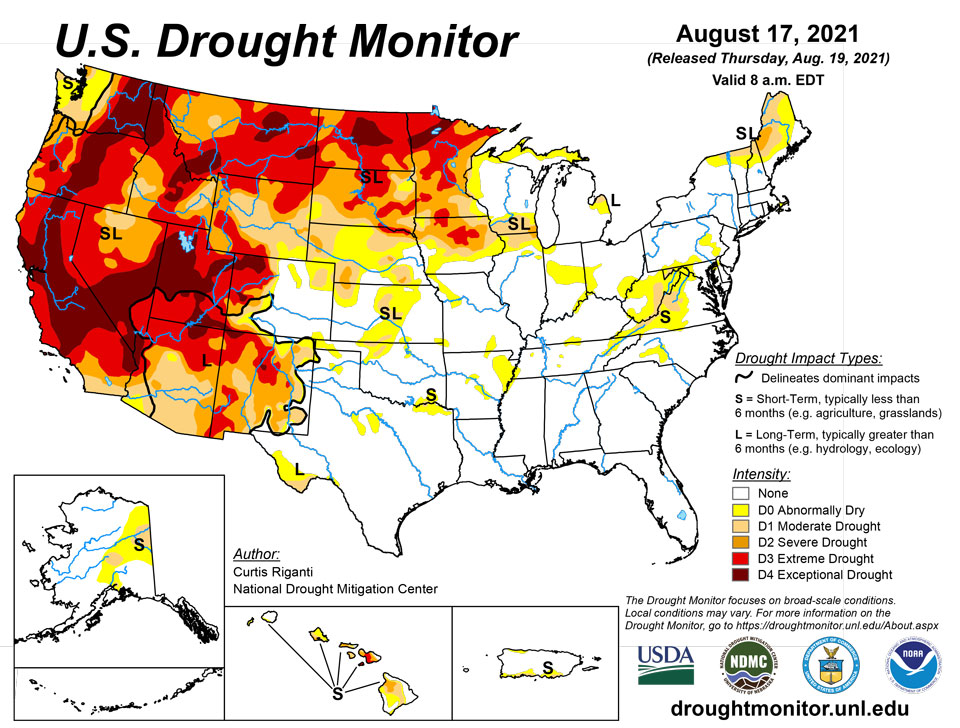
August 19, 2021 - Monsoonal moisture, and associated heavy rainfall, returned to Arizona and New Mexico after a brief hiatus last week, leading to widespread improvements in drought conditions, as well as some flash flooding. In most of Arizona and New Mexico, long-term drought remains, but recent conditions have been wet enough for a green-up in vegetation. Meanwhile, warm and dry weather continued from the West Coast to the northern Great Plains. Tropical Storm Fred, and its remnants, progressed across the Southeast U.S., dropping heavy rain along the storm’s track, and to its east as well. Much of the rain in the drier areas of North Carolina, Virginia, and West Virginia fell after 8 a.m. EDT on Tuesday, so the effects from this heavy rain on dryness will be incorporated into next week’s analysis. However, some limited improvements to conditions did occur with rainfall before the Tuesday morning cutoff. Water shortages and wildfires continued to plague drought-stricken regions of the western and northwestern U.S., while very poor soil moisture conditions and severe agricultural impacts were felt in the northern Great Plains. In Minnesota, hydroelectric power generation along the Mississippi River halted near St. Cloud. River levels in the state lowered towards 1988 drought levels, creating a danger for boats to scrape along the bottoms of rivers. Rainfall from tropical cyclones in Puerto Rico led to improvement in moderate drought in southeast sections of the island. Maui and Hawaii also saw localized improvements of drought conditions from recent rainfall.
Northeast
Moderate and severe drought continued this week in northern sections of New England. Some rain did fall in this area (generally from a half inch to 2 inches), but not enough to improve the ongoing drought conditions. Heavier rain, with widespread amounts exceeding 2 inches, fell in western Pennsylvania and in West Virginia. Temperatures across the region were warmer than normal, with most places checking in between 3 to 6 degrees above average for the week.
Southeast
The big weather story in the region this week was Tropical Storm Fred, which made landfall near Cape San Blas, Florida. Heavy rain fell in a corridor extending from the middle of the Florida Panhandle to Virginia and West Virginia over the past week, much of it being related to Fred or its remnants. This rain led to some improvements in abnormally dry conditions in South Carolina, North Carolina, and Virginia, but the bulk of the heavy rain occurred after 8 a.m. EDT. The effects of this rain will be incorporated into next week’s analysis. Temperatures across the region were a mixed bag; near or slightly cooler than normal temperatures were common in Florida, Alabama, and Georgia, while much of North Carolina and Virginia saw temperatures range from 3 to 6 degrees above normal for the week.
South
Rain amounts from 2 to 6 inches occurred in far southwest Texas, in association with heavy monsoonal rainfall this week. Elsewhere, scattered moderate-to-heavy rainfall amounts occurred, with a few pockets, notably south Texas and northwest Oklahoma, staying mostly dry. Long-term drought continued in a small area around Big Bend National Park in southern Texas, while a few areas of shorter-term drought were occurring along the Red River and in northwest Oklahoma. Cooler than normal weather was common in southern parts of Texas this week, in particular where heavy monsoonal rains fell, where temperatures were 3 to 9 degrees below normal for the week.
Midwest
Spotty moderate-to-heavy rain fell in parts of Missouri, Illinois, northern Indiana, Ohio, central and eastern Kentucky, central and eastern Wisconsin, and Michigan. Meanwhile, western Wisconsin, Iowa, and Minnesota remained quite dry this week. Drought conditions worsened in eastern and central Iowa as a result, with large patches of severe and extreme drought covering the central and northern sections of the state. Some minor improvements to drought conditions occurred to the west of the Chicago area, but moderate and severe drought remained in the area. Widespread degradation in drought conditions occurred in Minnesota, where severe, extreme, and exceptional drought have increased their foothold across much of the state. Dropping water levels on rivers, statewide water restrictions, lack of grazing or hay available for livestock, and termination of hydroelectric power generation in St. Cloud have all been reported as impacts in Minnesota. Near normal to above normal temperatures occurred in northern Minnesota, Kentucky, southern Indiana, and southern Ohio, while near normal temperatures were common elsewhere across the region.
High Plains
Aside from a few pockets of heavier rain in parts of Kansas and in eastern and central Colorado, most of the region was dry this week. Warm temperatures held sway in Colorado, Wyoming, South Dakota, and North Dakota, where temperatures generally ranged from 3 to 6 degrees above normal. Moderate drought developed in northeast Colorado in areas which did not receive significant rainfall this week. Severe and extreme drought grew in coverage along the Missouri River in northeast Nebraska and adjacent South Dakota. Drought coverage also increased in northeast South Dakota and across parts of North Dakota. In North Dakota, some farmers have harvested corn to use as livestock feed as drought continues to adversely affect agriculture. A few parts of south-central Wyoming saw localized improvement in drought conditions due to recent rainfall, while others in the southeast and northwest corners of the state experienced worsening conditions.
West
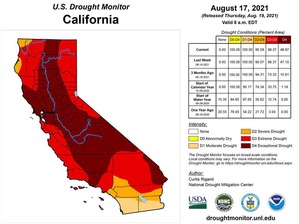
Amid water shortages and restrictions in the Colorado River Basin and widespread wildfires and extreme fire behavior in northern California and the Northwest, widespread severe, extreme, and exceptional drought continued across much of the region. Conditions worsened in northern California, western Oregon (and adjacent southwest Washington), southeast Oregon (and adjacent Nevada), and in northern and eastern portions of Montana, where soil moisture continued to degrade as hot and dry weather continued. In stark contrast, widespread improvements in drought conditions occurred in Arizona and New Mexico this week, as heavy monsoonal rains made their return after a one-week hiatus. Two-inch rainfall totals were commonplace, particularly in the southern halves of both states, and localized higher amounts also occurred. Most of the remaining drought in these states, while still extreme or exceptional in some locales, is confined to long-term impacts, as conditions are wet in many places on the short-term. While heavy monsoonal rain occurred in Arizona and New Mexico, moderate to heavy amounts were mostly confined to these two states. In central and southern Arizona and New Mexico, temperatures were cooler than normal, in some areas by 3 to 9 degrees. Otherwise, the rest of the region was warmer than normal, in particular northern California, Oregon, and Washington, where temperatures from 9 to 12 degrees above normal were widespread.
Caribbean
Heavy rains, with amounts ranging from 2 to 6 inches locally, fell on Puerto Rico, particularly in the southeastern portion of the island. This led to some improvements of ongoing moderate drought and abnormal dryness.
Tropical Cyclones Fred and Grace passed south of the U.S. Virgin Islands on August 10 and 15, respectively, delivering locally heavy showers and providing some relief from long-term dryness and drought. Each of the three major U.S. Virgin Islands experienced a one-category improvement, with lingering long-term impacts on St. John and St. Croix mostly related to groundwater shortages. On St. Thomas, where groundwater has recovered more efficiently, abnormal dryness (D0) was eliminated.
At Rohlsen Airport on St. Croix, rainfall totaled more than an inch during the approach and passage both tropical systems. The airport received 1.99 and 1.04 inches on August 8-10 and 14-15, respectively. Through August 16, month-to-date rainfall at Rohlsen Airport totaled 3.03 inches (194% of normal). Elsewhere on St. Croix, volunteer (CoCoRaHS) observers noted month-to-date totals (through the morning of August 17) ranging from 3.33 to 7.59 inches. At the USGS Adventure 28 well on St. Croix, depth to water peaked at 26.57 feet on August 6, followed by slight recovery. Noting recent heavy rain, but recognizing ongoing drought impacts on pond levels, subsoil moisture, and groundwater reserves, the drought status on St. Croix was changed from severe (D2) to moderate (D1).
On St. Thomas, groundwater levels at the USGS Grade School 3 well began to respond to rainfall several weeks ago. Depth to water peaked at 15.27 feet on June 3-4; in recent days, the depth has decreased to less than 8 feet. Volunteer (CoCoRaHS) observers on St. Thomas have received month-to-date rainfall (through the morning of August 17) ranging from 2.73 to 5.63 inches. King Airport on St. Thomas netted a daily-record rainfall total of 2.86 inches on August 15.
On St. John, variable rainfall and a modest groundwater response resulted in an improvement from moderate drought (D1) to lingering, long-term dryness (D0). The volunteer (CoCoRaHS) observer at Windswept Beach received a weekly rainfall of 3.47 inches, aided by tropical downpours associated with Fred and Grace. At the other active CoCoRaHS sites on St. John, month-to-date rainfall (through the morning of August 17) totaled 2.02 and 3.24 inches, respectively. Meanwhile, depth to water at the USGS Susannaberg DPW 3 well on St. John was as great as 18.26 feet as recently as August 11, but in recent days has rebounded to less than 17.5 feet.
Pacific
Recent rainfall led to improvements in drought conditions on eastern portions of Maui and Hawaii.
Inter-Tropical Convergence Zone (ITCZ) activity continued across southern Micronesia during this USDM week (3/27/19-4/2/19), while a dry trade-wind regime blew drier subsiding air from the North Pacific subtropical ridge (the North Pacific High) across northern portions of Micronesia. The ITCZ was manifested as a near-equatorial trough across western and central portions, and trade-wind convergence in the east where faster trade winds overtook slower trade winds. Weak disturbances developed and dissipated within the trough. The convection extended south of the equator as the South Pacific Convergence Zone (SPCZ), which was manifested as a surface trough extending just south of the Samoan Islands.
The ITCZ and SPCZ activity was reflected on satellite-based estimates of 7-day precipitation (QPE) as a band of 2+ inches of rainfall across much of Micronesia, then southeast across the equator to just south of the Samoan Islands. The rain band in Micronesia (ITCZ) mostly straddled 5 degrees North latitude across Yap State in the Federated States of Micronesia (FSM), extended toward the equator over Pohnpei and Kosrae States in the FSM, and lay mostly between 5 degrees N and the equator over the southern Marshall Islands (RMI). There were areas of 4+ inches of rain within the broader rain band, with some 10+ inch areas near where the disturbances developed. Little to no rain was indicated on the QPE in northern Micronesia north of the main rain band. The QPE rainfall estimates for the SPCZ appeared as a broken band of 2+ inches of rain to the west and south of the Samoan Islands.
Tropical Depression 16W crossed the Mariana Islands on August 17, passing over Guam. Despite lack of organization, the depression produced some gusty winds and heavy showers on several islands. On August 17, Saipan International Airport received 1.95 inches of rain and clocked a peak wind gust to 39 mph. Due to the tropical depression and earlier rainfall, the Marianas remain free of dryness and drought.
In the Federated States of Micronesia, short-term dryness has developed across a few eastern and southern islands. Namely, dryness (D0) that was recently introduced on Kapingamarangi and Lukunor remains intact. For the third consecutive week, rainfall totaled less than an inch on Kapingamarangi. Similarly, Lukunor reported a fourth consecutive week with less two-thirds of an inch. Reports from Lukunor indicate some yellowing of vegetation and below-average water supplies. Meanwhile, rainfall remains plentiful across most western FSM islands.
Portions of the Marshall Islands continued to experience a short-term drying trend, although some atolls received substantial rain. For example, Majuro received more than 2 inches of rain on August 4 and 9. In addition, reservoir storage on Majuro rose above 30 million gallons on August 5 and has subsequently remained there, peaking at 31.615 million gallons on August 12. Meanwhile, Wotje netted at least 1.50 inches of rain for the fifth time in the last 6 weeks. Only light showers fell on Mili, though a wet pattern from March into July precluded the development of abnormal dryness. Short-term dryness (D0) was introduced on Kwajalein, where rainfall during the 3-week period from July 28 – August 17 totaled just 2.24 inches. Elsewhere, the depiction of abnormal dryness (D0) was retained for Jaluit, while moderate drought (D1) was introduced on Ailinglapalap. Rainfall on Jaluit has totaled less than 2 inches during 9 of the last 10 weeks, while Ailinglapalap has reported below-average rainfall each month starting in May—including a 2.69-inch total in July.
The Republic of Palau has received sufficient rainfall in recent weeks to remain free of dryness and drought. Palau International Airport collected a weekly rainfall total of 1.73 inches. The cooperative observation site at Koror, Palau, netted 5.03 inches of rain during the first 17 days of August.
Relatively tranquil weather prevailed in American Samoa, with weekly rainfall totals ranging from 0.42 inch at Pago Pago International Airport to 2.53 inches at Siufaga Ridge, a National Park Service site. The airport location reported 4.47 inches of rain from August 1-17. Due to earlier wetness and ongoing shower activity, American Samoa remains free of dryness and drought.
Looking Ahead
As of Aug. 18, the National Weather Service (NWS) Weather Prediction Center is forecasting several areas of significant precipitation from Aug. 18-23. As a storm system advances eastward out of the West, moderate to heavy rain is possible from central and eastern Utah northeast into the northern Great Plains and western Minnesota. Significant precipitation is also possible in western Wyoming and in parts of Montana. Any rainfall in these areas would be welcome, as much of the region forecast to receive rain is in drought. Additionally, moderate to heavy rain may occur in Tennessee and northern sections of Alabama and Mississippi. Finally, heavier rain may also fall in the Mid-Atlantic and in the Northeast. In the Northeast, the eventual track of Tropical Cyclone Henri may play a large role in rainfall amounts. To monitor the track and possible local impacts of Henri, please refer to the NWS National Hurricane Center’s latest forecasts, or those from your local NWS office. For the period from Aug. 24-28, the NWS Climate Prediction Center forecast leans towards warmer than normal temperatures in most of the contiguous United States, with the exception of the northern Great Plains and the Upper Midwest. Forecast probabilities strongly lean towards below normal precipitation in much of the West and northern Great Plains, while the Northeast, Southeast, and portions of the South are skewed towards likely wetter conditions.
Author(s):
Curtis Riganti, National Drought Mitigation Center
Brad Rippey, U.S. Department of Agriculture
Dryness Categories
D0 Abnormally Dry—used for areas showing dryness but not yet in drought, or for areas recovering from drought.
Drought Intensity Categories
D1 Moderate Drought
D2 Severe Drought
D3 Extreme Drought
D4 Exceptional Drought
Drought or Dryness Types
S Short-term, typically less than 6 months (agriculture, grasslands)
L Long-term, typically more than 6 months (hydrology, ecology)
SL Area contains both short- and long-term impacts
Source: National Drought Mitigation Center
