


California and National Drought Summary for August 24, 2021
Summary
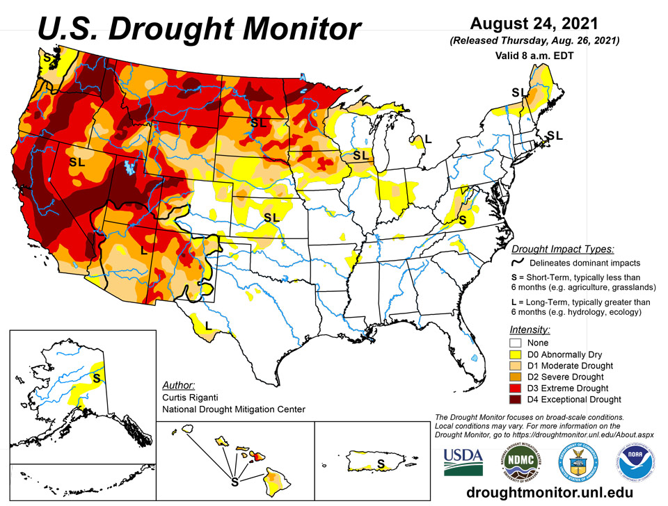
August 26, 2021 - Temperatures this week were generally cooler than normal west of the Continental Divide, while warmer than normal temperatures were common in the Upper Midwest and Northeast. Heavy rain fell across widespread sections of the eastern United States, in many locations due to the influences of tropical cyclones Fred and Henri and their remnants. The widespread rainfall led to condition improvements in areas suffering from abnormal dryness or moderate drought. Tragically, this led to a flash flood event with numerous fatalities in Tennessee. Parts of the Midwest, High Plains, and West regions received beneficial rainfall this week, which led to improvement in drought conditions in some locales. Many locations across the central United States that missed out on heavier rains this week saw drought conditions degrade.
Northeast
In the Northeast this week, widespread heavy rain fell in most areas, excluding northern Maine and far northern New Hampshire, in association with Fred and Henri. The heaviest amounts, with some areas exceeding 5 inches, fell in southern New Jersey and eastern Pennsylvania. Most of the region also experienced warmer than normal temperatures, with many spots ending up 4 to 8 degrees above normal for the week. Conditions continued to dry in Cape Cod, where a small area of severe drought developed this week. Moderate and severe drought continued in northern New England, and a bit of moderate drought remained in West Virginia, amid widespread improving conditions after rainfall there.
Southeast
Moderate drought conditions improved in parts of Virginia after rainfall associated with Fred this week. Elsewhere, drought conditions were pretty quiet, with a few areas of short-term abnormal dryness in North Carolina and Virginia. Wet weather was widespread this week as Fred progressed from the Florida Panhandle northward into the Appalachians, depositing heavy rain amounts of 2 inches or more along and to the east of its track. Temperatures were near normal from northern Alabama and Georgia to western North Carolina, and were generally 2 to 6 degrees above normal elsewhere.
South
Heavy rains fell this week across parts of central and northeast Texas (and adjacent southeast Oklahoma), in much of central and eastern Tennessee, and in northern Mississippi and Louisiana. A small area of short-term moderate drought straddling the Red River in southeast Oklahoma/northeast Texas received sufficient rainfall to see conditions improve out of drought. Heavy rainfall led to the removal of moderate drought in parts of eastern Tennessee. Northwest Oklahoma was left drier this week, and small areas of short- and long-term moderate drought expanded there and in adjacent southern Kansas. Temperature departures varied across the region and generally were not extreme in either the warm or cool direction.
Midwest
Weather conditions varied widely across the Midwest this week. As a common denominator, the entire region saw warmer than normal temperatures, with the warmest temperature departures (from 6 to 10 degrees above normal) taking place in Michigan and Minnesota. Rain fell across roughly the southwestern half of Missouri, Iowa (north of Interstate 80), the western two-thirds of Minnesota), far southeast Ohio, and Kentucky, as well as a few other isolated spots in southern Illinois. Elsewhere, the weather was largely dry. Very dry weather over the last month, and associated impacts to soil moisture, led to the formation of short-term moderate drought in central Indiana. Recent dry conditions also led to expansion of moderate drought in northern Wisconsin and the Michigan Upper Peninsula. Recent heavy rain allowed for some improvements in drought areas in Iowa and Minnesota (where the heaviest amounts occurred to alleviate very short-term dryness), but longer-term deficits and impacts to the hydrologic system remain across the greater part of the two states. The Boundary Waters Canoe Area Wilderness in northern Minnesota closed recently due to a nearby wildfire. The ongoing drought has also adversely affected bee populations and honey production. Low streamflow in rivers in Minnesota remained a problem this week. In some areas of northeast and southwest Minnesota that didn’t see much or any rain this week, extreme drought widened its footprint.
High Plains
In the High Plains region this week, temperatures were mostly below normal west of the Continental Divide in Colorado, in Wyoming, and in far western parts of South Dakota and North Dakota. Elsewhere, temperatures were generally above normal. Rain fell over wide areas of Nebraska, South Dakota, North Dakota, Wyoming, and western Colorado, leading to some improvements in drought conditions. Parts of the Missouri River Valley in northeast Nebraska, northwest Iowa, and southeast South Dakota did not see much rain, however, and moderate, severe, and extreme drought expanded there. Heavy rain, with some areas seeing 5 or more inches, struck northeast Colorado and southwest Nebraska, though as is typical of warm season thunderstorm complexes, rainfall gradients were rather tight in some areas. Drought conditions improved in areas that saw heavy rain, while some expansion of severe drought occurred in areas of southwest Nebraska that missed out on the rain, where agricultural drought impacts and precipitation deficits have been mounting. Heavy rainfall in North Dakota led to some localized improvements to ongoing drought, though some short-term and especially long-term precipitation deficits remain in areas which received heavy rain. Ongoing drought also impacted the bee population in North Dakota.
West
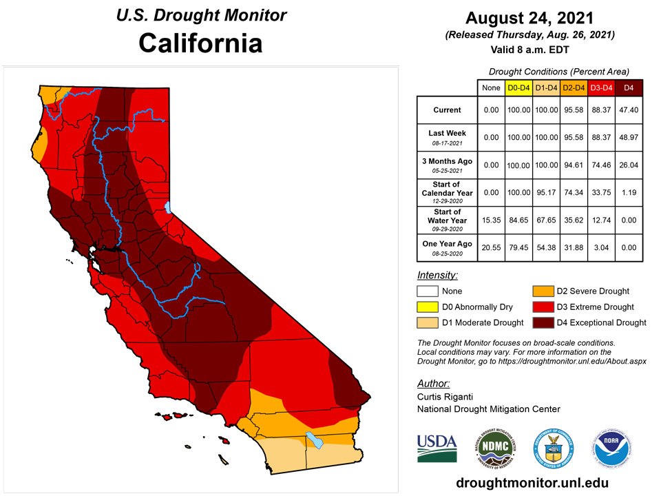
Drought continued to plague much of the West region of the United States this week. Heavy rains in parts of Arizona, Idaho, Montana, and Utah combined with well below normal temperatures (ranging from 4 to 8 degrees below normal) to stave off any expansion or worsening of drought areas this week. Due to recent monsoonal rainfall, drought conditions improved in northern Arizona and southern Utah, and adjacent parts of southern Nevada and southeast California, and in New Mexico. Heavy rain in the far northern Idaho Panhandle led to a small reduction in exceptional drought coverage. It is possible that conditions may continue to improve in some locations after this week’s rainfall, though it is currently unknown how beneficial this week's rains were in locations that were quite dry previously.
Pacific
On Maui, rainfall fell on the northeast-facing slopes of the West Maui Mountains, lessening rainfall deficits and returning streamflow to normal, so conditions improved there. Some improvements to drought conditions occurred on Oahu as well, where increasing rainfall on the northeast-facing slopes of the Koolau Range improved streamflow.
Recent precipitation in Alaska led to the removal of short-term moderate drought in eastern parts of the state.
Following the recent passage of Tropical Depression 16W across the Mariana Islands, seasonably wet weather—featuring locally heavy showers—continued. For the month to date through August 24, rainfall at Guam International Airport totaled 11.93 inches. Portions of several islands, including Guam and Saipan, received weekly rainfall totals exceeding 3 inches, leaving the Marianas still free of dryness and drought.
In the Federated States of Micronesia, short-term dryness has developed across a few islands. Despite a few showers, dryness (D0) that was recently introduced on Kapingamarangi and Lukunor remains intact. Kapingamarangi received more than an inch of rain during a drought-monitoring period for the first time since late July. Lukunor received a weekly rainfall total exceeding 2 inches for the first time since June 30 – July 6. Meanwhile, a short-term drying trend on Chuuk Lagoon resulted in the introduction of D0. From August 1-24, rainfall on Chuuk Lagoon totaled just 4.32 inches, less than half of normal. In contrast, rainfall remains plentiful across most western FSM islands, with Yap reporting 11.20 inches during the first 22 days of August.
In the Republic of the Marshall Islands, a few southern and western atolls are experiencing short-term dryness (D0) or moderate drought (D1). Kwajalein, which received just 2.49 inches of rain in the 4-week period from July 28 – August 24, remained in D0. Jaluit also remained abnormally dry, having noted rainfall totaling 2 inches or less during 10 of the last 11 weeks. D1 persisted on Ailinglapalap, where consistently drier-than-normal weather has prevailed for nearly 4 months.
Heavy rain fell across the Republic of Palau, with a weekly total of 6.03 inches reported at the international airport and more than 4 inches observed at the cooperative site in Koror. For the month to date through August 24, rainfall at the airport reached 11.06 inches.
Showery weather prevailed in American Samoa, maintaining dryness- and drought-free conditions. Weekly rainfall ranged from 1.79 inches at Pago Pago International Airport to 2.92 inches at Siufaga Ridge, a National Park Service site. The airport location noted 6.26 inches of rain from August 1-24.
Caribbean
Following the mid-August departure of Tropical Cyclone Grace, hot, dry weather settled across the U.S. Virgin Islands. Despite the return to dry weather, there were no changes in the depiction for the territory, with abnormal dryness (D0-L) continuing across St. John and moderate drought (D1-L) persisting on St. Croix, mainly due to long-term impacts such as groundwater and subsoil moisture shortages.
At Rohlsen Airport on St. Croix, August 17-23 rainfall totaled just 0.03 inch, although the month-to-date total of 3.06 inches remained above normal. Volunteer (CoCoRaHS) observers on St. Croix noted similar weekly amounts, ranging from 0.02 to 0.19 inch. Depth to water at the USGS Adventure 28 well on St. Croix rebounded to 26.25 feet on August 24, a slight improvement from the recent (August 6) depth of 26.57 feet.
At King Airport on St. Thomas, August 17-23 rainfall totaled 0.03 inch, following a 2.86-inch deluge on the 15th. King Airport also experienced hot weather, with high temperatures reaching 90°F or higher each day starting August 17. In addition, the airport’s low temperatures fell only to 83°F on 4 consecutive days from August 20-23. Volunteer (CoCoRaHS) observers on St. Thomas received rainfall ranging from 0.02 and 0.13 inch during the drought-monitoring period. Depth to water at the USGS Grade School 3 well on St. Thomas began to increase, rising from 7.53 to 9.69 feet between August 17 and 24.
St. John also experienced mostly dry weather, with volunteer (CoCoRaHS) observers reporting weekly amounts ranging from 0.03 to 0.16 inch. Depth to water at the USGS Susannaberg DPW 3 well on St. John was as great as 18.26 feet as recently as August 11 and improved to 17.25 feet by August 17—but increased to 17.68 feet by August 24.
Looking Ahead
As of Aug. 25, the National Weather Service (NWS) Weather Prediction Center is forecasting two areas of heavy rainfall between Aug. 26-31. The first is expected to span from southern North Dakota south to northeast Nebraska, then northeast to Lake Superior. The second, which is expected near the end of that period, is expected near coastal parts of Texas and Louisiana. From Aug. 31-Sept. 4, the NWS Climate Prediction Center’s forecast leans towards near normal or warmer than normal temperatures for much of the contiguous United States. However, the forecast for the Pacific Northwest leans towards cooler than normal conditions being more likely. Warmer than normal temperatures are also likelier in Alaska during this period. Below normal precipitation is favored in the Pacific Northwest, western Texas and eastern New Mexico, the Florida Peninsula, and parts of the Northeast. Wetter than normal conditions are favored to extend from Arizona and Utah through the northern Great Plains and Upper Midwest, and from Texas and Louisiana northward through the Lower Mississippi River Valley.
Author(s):
Curtis Riganti, National Drought Mitigation Center
Brad Rippey, U.S. Department of Agriculture
Dryness Categories
D0 Abnormally Dry—used for areas showing dryness but not yet in drought, or for areas recovering from drought.
Drought Intensity Categories
D1 Moderate Drought
D2 Severe Drought
D3 Extreme Drought
D4 Exceptional Drought
Drought or Dryness Types
S Short-term, typically less than 6 months (agriculture, grasslands)
L Long-term, typically more than 6 months (hydrology, ecology)
SL Area contains both short- and long-term impacts
Source: National Drought Mitigation Center
